Page 13
Searches the whole library — filter by sim & category on the results page
NL2000 version 4 libraries provide a core foundation for Dutch airports, including object models, effect files, and AI traffic definitions that shape realistic operations across the country. The NL…
 Netherlands
Development spans nine months as Laughlin area improvements center on Bullhead City's KIFP and nearby Laughlin, NV, introducing a redesigned terminal and new models by Josephs Jasper. Scott Peterso…
 United States of America
Ray Smith leads a Venice-area airport upgrade designed with ADE v1.46, featuring a rebuilt terminal and corrected gate and parking numbering. Two BGL files exist, LIPZ_ADE_RS.BGL and LIPZ_ADE_OBJ.b…
 Italy
Italy
Barbuda enhancement updates coastlines and notes Codrington (TAPH) and Coco Point Lodge, with roads adjusting to land class. Valladier Jean Louis notes BARBUDA-1.ZIP as free to use for any sim but …
 Antigua and Barbuda
By Robert Catherall, the CYQQ ADE upgrade modernizes Comox with ADE v1.40, relocates runways and adds a civil terminal to reflect the base layout 2.5 NM north-northeast of Comox, BC. It includes CY…
 Canada
Charleston-area airfield (KCHS) in South Carolina, by Ryan Cobb, receives a complete rework featuring new hangars, a fire department facility, a Boeing plant, runway distance remaining signs, and a…
United States of AmericaIan Thatcher provides a revised landclass for New Zealand, based on his earlier work, and ships a single BGL file. Spring through fall guide the results, while winter appearances remain mismatched …
 New Zealand
General Jose Francisco Bermudez Airport SVCP in Carupano, Venezuela, has a terminal building, a control tower, a fire station and heliports. The work is by Jaime Ortega and is freeware, focusing on…
 Venezuela (Bolivarian Republic of)
Moody AFB (KVAD) receives a clarified update by Jim Cook, adding Military_Cargo and Military_Combat parking, relocating the control tower, and outfitting a new helipad with fire trucks. It ships wi…
United States of AmericaThe eight airports span Brussels EBBR, Frankfurt EDDF, Schönefeld EDDB, Tegel EDDT, Barajas LEMD, Charles-de-Gaulle LFPG, Fiumicino LIRF, and Lisbon LPPT. ADE v1.37 underpins all BGLs, with two EDD…
 Global (World)
Two airports in Itanhaem, SDIM and SDCR, receive v2.0 work by Ren Scen, providing runways, taxiways, parking positions, and buildings for the town in Brazil. A single .BGL file is used and it impro…
 Brazil
Araraquara Airport (SBAQ) lies in São Paulo, Brazil, with expanded details for the facility. Cesar Marinho Costa, from Rio de Janeiro, Brazil, contributes added details in June 2007, documenting th…
Brazil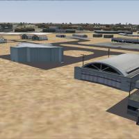
Registration FVHA in Zimbabwe anchors a complete rework of the airport, with a layout file included that adds buildings and objects beyond stock simulator models. Cargo adds to the ramp and parking…
 Zimbabwe
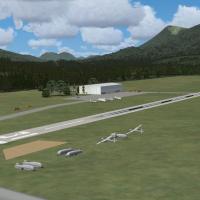
In Austria, the Sankt Johann in Tirol airfield receives a complete new layout created with ADE by Christopher Schenk, with beta tester Florian Berger contributing to validation; the project highlig…
 Austria
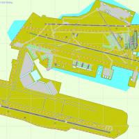
Indira Gandhi International Airport (VIDP) in India has a taxiway network laid over a satellite image. AIP data guides 11-29 navaids, and T2 plus the cargo terminal move south to their actual posit…
 India
IndiaDusty Bizub marks his sixteenth airport modification for Charlotte Douglas International Airport in North Carolina, using the KCLT designation. It refines gate assignments and corrects runway numbe…
United States of America
At Scott Air Force Base, the Midamerica II air show presents a static Blue Angels display and an F-22 demonstration, linking it to the base’s public event. A file named scott.bgl accompanies the pr…
United States of America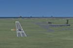
By Severin Afari, the project expands Accra's DGAA with additional structures visible beyond runway 21 and introduces extra grass around the field. A static MD-90/80 rests near the military tarmacs…
 Ghana
Ghana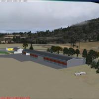
The LSZI facility sits in the eastern Jura hills near Basel, Switzerland, and is documented by Michael Bruttel, using Google Maps imagery alongside Skyguide charts. ADE by Jon Masterson facilitates…
 Switzerland
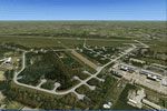
The NL2000 v4.03 edition covering Volkel airfield, designed by The Netherlands 2000 Design Team, depicts accurate runways and taxiways aligned to real coordinates, plus hardened shelters and suppor…
Netherlands