
By Ray Smith, this Dubai International Airport enhancement uses a BGL file generated with ADE Home Edition, adding support vehicle roads, an extra fuel truck fleet, a helipad, and assigned parking …
 United Arab Emirates
Renovation of MMMMX unfolds with a south side Terminal 2, assigned parking, and revised taxiways, implemented by Ray Smith using ADE v1.37 for the MMMMX project. A single BGL MMMMX.BGL controls the…
 Mexico
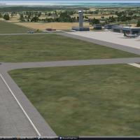
By Matthew Brooks and Alpha India Group, RPMD v2 updates aprons and taxiways to align with imagery dated February 2010 and rewrites approaches per Jeppesen plates. It adds GA parking, a fire statio…
 Philippines
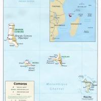
By Hely Heck Junior and Jose Lobo TerraBrasilis, Madagascar’s terrain data uses 90m SRTM2 data reprocessed with 3DEM to remove voids and spikes, yielding 76.4m horizontal resolution (LOD9). It cove…
 Madagascar
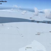
An Antarctic outpost near the South Pole comprises three airports NZPG, NZIR and NZWD, with ice and snow runways about 10,000 feet long. Additional objects include an observatory, two tourist ships…
 Antarctica
Valladier Jean Louis presents a Grande Case project that models the Grande Case (TFFG) airport and provides a more accurate Tintamare redesign, while remaining compatible with Caribbean mesh in LOD…
 Saint Martin (French part)
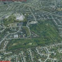
Jim Jones crafts ten sections of one-meter-per-pixel photoreal terrain data for Lexington, KY, totaling about 600 MB and spanning roughly 245 square miles, LexXP1Ma through LexXP1Mj. Daylight use a…
 United States of America
Seventeen Dutch airports, including EHAL and EHBD, gain parking facilities and taxiways, while Traffic Tools generates a flight plan and AI aircraft for these airports. Most are forgotten by Micros…
 Netherlands
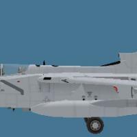
Located at LEAB, Spain, the project is v1.0 featuring AI traffic, photo-real imagery, buildings, and navigation charts, and supports two B-737s plus four light aircraft. The field serves the Air Fo…
 Spain
Spain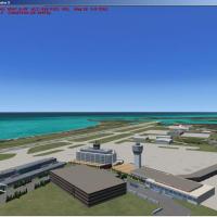
The Puerto Rico file covers the islands of Puerto Rico, Vieques, and Culebra, and includes 24 airports, with Luis Munoz Marin International Airport (TJSJ) and Morro Castle reconstructed from photog…
 Puerto Rico
VOBL in Bengaluru, India, opens to commercial traffic on 23/05/2008, replacing the closed HAL Bangalore Airport (VOBG). NAVAID data list ILS for Runway 9 IBAN 109.3 and Runway 27 IDEV 108.3, plus V…
 India
India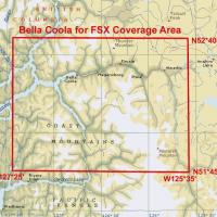
Multi-LOD 38-m mesh and the local landclass, water class, and seasons files cover the Bella Coola area (N51*45'-52*40' W125*35'-127*25'), with accurate placements of lakes, rivers, roads, and strea…
 Canada
A Griffiss AFB installation in New York from the late 1980s features native objects by Jim Dhaenens, using GMAX and the SP-2/Acceleration SDK, including lighting elements such as roundspot, 4litesq…
United States of America
By Cicero Costa, this Iguassu Falls project presents a five-meter mesh for the falls region on a landclass layer across the region. It relies on MeSA_E08.bgl and uses 3DMax for bridge modeling acro…
 Global (World)
Dublin's 2010 layout places Pier A through D with the West Apron and notes F-INN without a T2 area. Overspill parking expands and the cargo area extends, while Gate 36 enlarges to accommodate Aer L…
 Ireland
Operators at Corpus Christi, Texas, host two primary-flight squadrons, VT-27 and VT-28, flying the T-34 Mentor, alongside VT-31 and VT-35 for intermediate training with the T-44 Pegasus or UC-12 Hu…
United States of America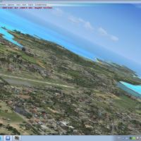
By Valladier Jean Louis, Anguilla V2 refines coastlines and land class while modeling Wallblake (TQPF) airport and The Valley. Roads and traffic adjust with land class, and it remains compatible wi…
 Anguilla
Version 2 introduces an ILS-enabled layout for runway 27, offering a refined approach context for a high-elevation setting and precise alignment cues. Elevation sits calmly at 11,710 ft, underscori…
 China
China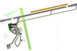
NZQN, Queenstown, New Zealand, gains a precise improved ILS, and parking areas are altered significantly to accommodate larger aircraft, while four NZQN-named files are included, credited to John B…
 New Zealand
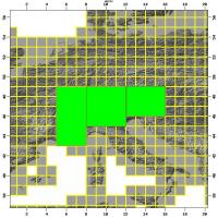
Alps terrain data presents a 38-meter resolution mesh covering the region, offering precise elevation across the range. It is designed with an SDK and includes multi-LOD, remains frame-rate friendl…
Global (World)