Page 3
Searches the whole library — filter by sim & category on the results page
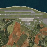
A freeware enhancement of the Sao Luis airfield SBSL in northern Brazil updates the ground layout and taxiway signage. Gustavo Luna creates it, using SBRF_patioLuz.bmp in the TEXTURE subfolder and …

Named for KLAX, the v3 rebuild reconstructs the airport layout with resized terminals and photoreal ground textures, and it relies on ADE, Google SketchUp 8, and SBuilderX to align runways and apro…

BlueSkyScenery delivers a statewide photoreal imagery package that spans California, from the Mojave Desert to Los Angeles and San Francisco, with over 70GB of data at 1m per pixel detail. Airfield…

Photoreal redesign of KJFK uses ADE v01.50.11 and SBuilderX to add the American Airlines and JetBlue terminals, parking structures, warehouses, and extra gates, with runways and aprons aligned to s…

An AFX file introduces the OMDB layout, adding a passenger terminal, cargo area, flower center, fuel tanks, private terminal, and parking for A380s. ATC directs AI and user aircraft to numbered pos…

Version 2 of the SRTM 3 mesh covers Europe, forming part of a freeware worldwide coverage effort. The pair consists of two files, SRT2EUR.ZIP and SRT2EUR2.ZIP, with credit to Raimondo Taburet and J…

Sierra.Foxtrot-Design identifies LEIB_Ibiza_X as the SFD_LEIB_Ibiza_X directory, designed for integration within an Addon Scenery structure and containing the necessary components. Users place the …

Rhett Browning delivers a fully gmaxed Terminal D addition for Dallas-Fort Worth International, replacing the 2004–2005-era model with a complete airport layout and jetways. It places KDFW_ADE_RB.b…

Taxiway and apron positions update to align with AIP data, and the ILS with DME is refreshed to support routes, by Gernot Zander. The update removes EDDT and EDDI; it rebuilds area, towers and SMR …

LSZH in Switzerland appears in the V2 edition with a frame rate friendly layout. Terminals A, B and E gain gate-number signs and ground-painted taxiway markers for clearer orientation, while the up…

An add-on focuses on the southern Caribbean with mesh terrain crafted from Yohann Baptiste data and credits Toni Agramont. It covers 27 airports and aerodromes, plus 245 populations are spread acro…
Orlandy Perez profiles the first version, adding a new runway at MDPC and a tower area with more gates. The iteration emphasizes expanded infrastructure at MDPC, enhancing route capacity and termin…
Ten named variants cover Greek island airfields, including LGHI Chios, LGKO Kos, LGMK Mikonos, LGML Milos, LGMT Lesvos, LGNX Naxos, LGPA Paros, LGSM Samos, LGSO Syros, and LGSR Thira, with Greece a…

LGAV-based representation focuses on the Greek capital's airport, authored by Moraitis Vangelis, with a single variant stored in the LGIO_SAOxt folder. Daytime and nighttime aerial views accompany …

The Berlin Brandenburg project near Schönefeld, Germany, places a midfield terminal between two runways and targets an initial capacity of up to 30 million passengers, with expansion via satellite …
Ten Greek airfields are included, including LGKR Kerkyra, LGKF Kefallonia, LGZA Zakynthos, LGKC Kythira, LGIR Heraklion, LGST Sitia, LGIK Ikaria, LGLM Lemnos, LGPL Astypalaia, and LGKJ Kastelorizo.…

This depiction of RAF Mount Pleasant (EGYP) in the Falklands includes hangars, shelters, workshops, accommodation, and a night-lit magazine area. Layout based on Google Earth data from 2006; the ai…

A redesigned layout focuses on more accurate coasts and updated landclass around V.C. Bird International Airport (TAPA) and the city of St. John's, with roads adjusting accordingly. By Valladier Je…

Anthony Dyer creates version 2 landclass data for Scotland, spanning the Highland and Grampian regions and the Hebrides, Orkneys and Shetland Islands, derived by hand from background satellite phot…

By Shanard Letang, this upgrade of Rafael Nunez International Airport (SKCG) in Cartagena, Colombia uses mapping software to ensure correct parking and adds GA parking. It focuses on the Cartagena …