Page 121
Searches the whole library — filter by sim & category on the results page
The work maps all Costa Rican airfields, placing them outside urban centers in beach, forest, and small towns surrounding the Metropolitan area, not located in major cities, across the country, exp…
 Costa Rica
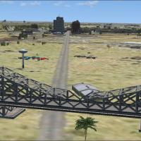
An add-on for Taji, Iraq by Steven Dean, adds military objects, buildings, and an emergency scene, and remains clearly fictional. It includes taji.bgl and taji2.bgl files to be placed in the addon …
 Iraq
Iraq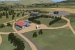
Alexandra Airport (NZLX) in Otago, New Zealand, gains a functionality-enhancing improvement and a revised airport layout file by Kade Bellaney, using ADE 1.45. A blg file is included in the archive…
 New Zealand
Eight sailboats race near Chester, Nova Scotia, with Ralph Eisenegger and Simaddons responsible for the setup. TrafficSimaddonsSailboatrace.bgl and the VEH_simaddons_sailboat folder are included, w…
 Canada
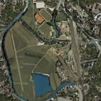
Located in southern Germany, Uwe Schweitzer presents Lichtenfels Airport (EDQL) as a photo depiction, a site about 15 nm WNW of Kulmbach serving a small aero club airfield in Franconia. It supports…
 Germany
The work centers on Ficksburg Airport in the Free State, South Africa, at the foot of Mpharane Mountain on the Caledon River, featuring completely custom-designed objects and effects and a base tha…
 South Africa
Two BGL files, KCON_AFX_JC.bgl and KCON_JC.bgl, govern Concord Municipal Airport in New Hampshire, upgrading taxiways, aprons, and roads, replacing default buildings with new structures, and adding…
 United States of America
A refined Lehigh Valley International (KABE) adds cargo and GA parking, a helipad, and a relocated control tower while adjusting aprons and taxiways and replacing several buildings with more accura…
United States of America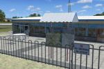
An add-on for the YGFN airport in Australia, created by John Ross, includes a small traffic file for touch-and-go operations and windsocks that rotate to wind direction. All resources stay within t…
 Australia
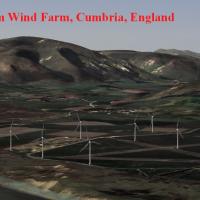
The wind installation sits just north of Barrow Airfield, near Millom in Cumbria, a site that clearly features turbines. Readers require all four volumes to view the turbines, by Neil Birch for Nei…
 United Kingdom
By John Ball, London Redhill, UK, serves LGW as a feeder concept with a 6500-foot jet runway, a light aircraft runway, and 26 remote gates sized for 24 narrowbodies plus two widebodies, linked to t…
United Kingdom
By John B. Loney, Jr., Plymouth Muni in Massachusetts (KPYM) gains a compatibility update designated kpym_fsx_update.zip for use with the original KPYM_V1.ZIP; the release preserves human figures w…
United States of America
At VNJP in Nepal, Antoine Calleja uses ADE9X with satellite imagery to shape a project for the area, integrating animated birds and refining aerodrome elements. The project adds airport frequencies…
 Nepal
NepalThe modification replaces the default C08 airport in WestCliffe, Colorado, with a larger Journey hub, created in Airport Design Editor. The C08_ADEX_ADE.BGL file brings night lighting, ILS approach…
United States of America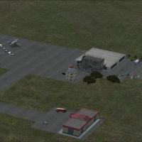
Antoine Calleja crafts an airport layout add-on for Simara Airport (VNSI) in southern Nepal, with ADE9X integration allowing precise runway, taxiway, and apron positioning. Google satellite referen…
Nepal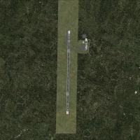
Gmax renders Havre-St-Pierre, CYGV, in Quebec, by recreating the terminal, hangars, fuel tank, gates, fences, and signs. This release remains freeware with redistribution restrictions and notes hel…
Canada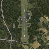
Jim Cook renders an enhanced Davison Army Air Field (KDAA) at Fort Belvoir, Virginia, replacing default structures with authentic buildings and adding hangars, administrative facilities, and static…
United States of America
The Netherlands 2000 Design Team crafts Enschede area aerodrome in Twente as part of NL2000 version 4, a freeware add-on that requires the NL2000 v4.0.32 installer for proper functionality. It refi…
 Netherlands
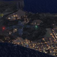
By Gera Godoy Canova, development focuses on Adams Island within New Zealand’s Auckland Islands archipelago, adding a lighted dirt strip and a new land class. Enclosed .BGL files appear, while Sout…
New Zealand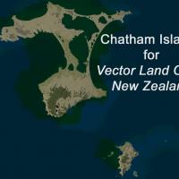
A modified version integrates Chatham Islands Tuuta NZCI, Napier NZNR, and Pitt Island Airstrip NZPI with Vector Land Class New Zealand, enabling seamless switching between environment configuratio…
New Zealand