Page 126
Searches the whole library — filter by sim & category on the results page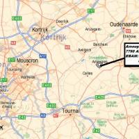
Near the town of Amougies in Belgium lies the EBAM airstrip, about 610 meters long and 22 meters wide, with two elevation options delivered as bgl files, depending on standard layouts or a custom B…
 Belgium
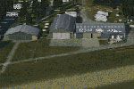
By The Netherlands 2000 Design, the glider strip in Axel integrates with the NL2000 v4 framework and delivers accurate field features plus high-fidelity terrain in the southwestern Netherlands. The…
 Netherlands
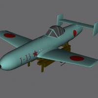
The OHKA MXY7 offers MDL form and a library, and object placement tools position it in any environment. By Guy Diotte using Gmax, the asset reflects original geometry and remains compatible with co…
 Japan
Japan
North Eleuthera Airport (MYEH) receives a thoroughly updated upgrade that positions two provided folders into the addon library, aligns runway and taxi areas with imagery references, and mirrors ne…
 Bahamas
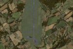
Padraic Ó hEithir creates a Northern Ireland airfield record, ICAO EGAB, detailing taxiways A and B, C1-C2, D1-D4 and F. The work uses ADEX v01.47.07 and preserves the layout clearly for reference …
 United Kingdom
By John Ball, the Waterford EIWF in Ireland enhancement adds a terminal building and a control tower, and includes ILS at both runway ends along with a 4700-foot runway that accommodates light jets…
 Ireland
Monroe's Custer Airport carries ICAO code KTTF and FAA LID TTF, and marks George Armstrong Custer as its namesake. Its origins trace to November 1946, and it accommodates single- and twin-engine ai…
 United States of America
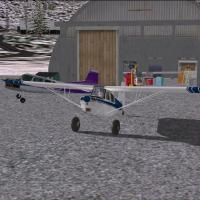
Chitina Airport (CXC) in Alaska operates as a bush strip featuring a hangar, FBO, loading area, a helicopter pad, and a float plane dock at the northern end of the runway. The scene includes a down…
United States of America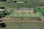
By Chris Brown, this Harewood House patch targets the UK location and replaces harwud.bgl when used with HARWUD.ZIP. The harwdfix folder houses the correction, addressing flower pots that migrate t…
United Kingdom
An amateur project by Bob Caparoula renders Angel Fire's GA airport at KAXX in New Mexico, using a single BGL file named Angel_Fire_KAXX.bgl. It is freeware for personal use and represents the faci…
United States of America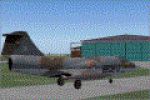
An accurate representation of EHDL near Arnhem presents true-to-life runway and taxiway layouts reflecting the airfield blueprint, while aerial imagery provides authentic ground visuals and surroun…
Netherlands
The KRID field in Indiana has multiple runways, with a paved main strip extending 5200 feet. Its elevation reaches 1140 feet, it sits about five miles from the town of Richmond, and Richmond Boac o…
United States of America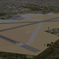
Located in Illinois, this portrayal centers on Glenview Naval Air Station, which originates as a Curtis-Wright airfield that the Navy renames in 1937. By 1993 the base closes and is dozed, leaving …
United States of America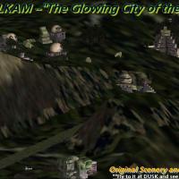
By Gera, Tikam-Ulkam presents a jungle-carved airfield for small aircraft where rocks glow at dusk and throughout the night. The setup uses .bgl files and .BMP images to realize the effect, and the…
 Guatemala
Airfields include Totana, Los Garranchos (my own field), Los Martinez, Catral, Los Maldonados with a 1100 metre tarmac strip, and Vera Airfield featuring a 400 metre runway. By John Reynolds, Los G…
 Spain
Spain612 pylons mark the Birmingham International approach at EGBB, laid out along the approach path and aligned with image-based terrain visuals. Neil Cooke crafts a single bgl file that aligns with ar…
United Kingdom
Phillip Coyle creates an add-on that reworks KCIC to match real-world dimensions, using aerial imagery to align taxiways, runways, and parking with documented specifications. The add-on uses Airpor…
United States of America
Tonopah Airport (KTPH), Nevada, gains multiple BGLs that add ramp parking for small GA aircraft, plus roads and assorted objects to better reflect the site, while removing the default boundary fenc…
United States of America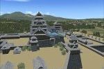
Seven castles, including Himeji, Kumamoto, Osaka, Edo, E Yatsushiro, Hikone, and Goryoukaku, stand at the foot of Mt. Youteizann in Hokkaido. Harutoshi Nakagawa is the creator, and the arrangement …
Japan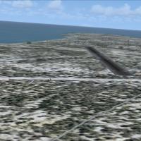
By Martin Rothenmund, an abandoned airstrip sits on the northern part of Urup in the Kuril Islands, a remote, uninhabited island roughly 60 sm long and 20 sm wide, accompanied by rusty military equ…
 Russian Federation