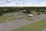
An enhanced variant of Sullivan County International Airport (KMSV) in Monticello, New York reconfigures aprons, relocates roads, and replaces every building, adding static airplanes and a parking …
 United States of America
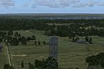
Geneva NY, by Dick Kittredge, sits at the northern tip of Lake Seneca in the Finger Lakes region. GenevaNY.bgl resides in the addon folder, and placing objects relies on an auxiliary utility, with …
United States of America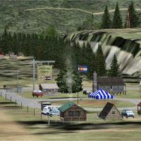
Bernie Martin issues a small correction for Nutmeg Cabins, for use with NUTCABS.ZIP. The enclosed .bgl file fixes an omission where Colorado did not appear in the go to airport search, ensuring the…
United States of America
The add-on centers on the airfield in Utah, identified as 42U, by Jimmy R. Martin, and depicts vehicles, aircraft people, and lighting. Its concise scope anchors the scene around a small Utah airst…
United States of America
Across Marysville, California, the airfield at KMYV receives an updated layout with an added apron around runway 5/23 and revised parking, taxiways, and runways mapped using real satellite images. …
United States of America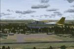
Januaria Airport (SNJN) in the city of Januaria, Minas Gerais, Brazil, receives added details that enhance the airfield's presentation. The work is free and available to anyone or any site, but can…
 Brazil
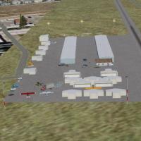
In Arizona, a private airfield identified by the code 57AZ undergoes an upgrade using default and add-on objects, with credit given to Jimmy R. Martin. Two EZ/RWY12 library files, Airport_Buildings…
United States of America
Haverstraw Heliport, designated H43, in New York serves air freight and charter operations for the town of Haverstraw along the Hudson River valley. The layout is designed from aerial photos and th…
United States of America
By Jim Cook, Marlboro Airport at 9B1 in Marlborough, MA gains an enhanced layout with adjusted aprons, roads and taxiways, plus replaced default buildings and added area structures such as barns, h…
United States of AmericaLKSTX 1.0 centers on the Strakonice area in the Czech Republic, including Strakonice LKST, backup LKSR, and parts of Volyne and Pisek, by Pavel Krejci. It uses 3D objects with minimal detail and re…
 Czechia
The EHSB 1980 variant centers on Soesterberg Air Base as it appeared in the eighties. The NL2000 v4.0.20 installer enables this edition, and the lineup maps the Netherlands with an eighties-era foc…
 Netherlands
At the airfield identified by code E95 in Arizona, the offering emphasizes lighting, people, objects, and the placement of buildings to create a straightforward environment. It credits Jimmy R. Mar…
United States of America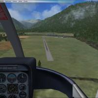
Gloriavale NZHP sits near Lake Haupiri on New Zealand's west coast, inland from Greymouth, and serves Air Westcoast and the Gloriavale Christian Community. By Nick Hobart, ADE 1.37 guides the proje…
 New Zealand
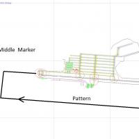
Charallave International del Centro (SVCS) in Venezuela near Caracas implements a real ILS approach with an audible middle marker and cockpit-light indications. Runway 10 adopts a right-hand patter…
 Venezuela (Bolivarian Republic of)
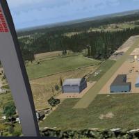
GA2 airfield near Williamson, Georgia, USA, features objects and lighting, with a hangar sign made by John B Loney. GAPLANE1.ZIP is required for some aircraft, and GA Planes 1 is repackaged by Stev…
United States of America
Jimmy R. Martin serves as designer and mapper for Galeton, Colorado (CO59). The work requires a free RWY12 EZ object library and leverages Ultimate Terrain USA for landclass, with FS Genesis terrai…
United States of America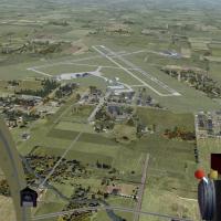
In Ohio, KMNN gains a reopened runway and improved building placement using library assets, by Jimmy R. Martin, with flashing end strobes on all runways. The note KMNN_MISSINGFILES.ZIP is mentioned…
United States of America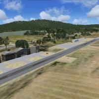
Located in the north of Israel, Dalton Airstrip (LLDL) anchors regional aviation activity and serves as a reference point for its rural air operations. Version 2 uses a Gmax model built from real p…
 Israel
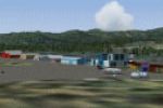
CYXC at Cranbrook receives a CYXC_FSX.ZIP update that incorporates runway extensions, credited to P. Nigel Grant and Vern Opperman, with location noted as Vancouver. The changes rely on CYXC_ADE_VO…
 Canada
The field spans 120 acres in central New Jersey, located five miles south of Old Bridge and identified by code 3N6. 100LL fuel is available, and the layout requires layering above the underlying im…
United States of America