Page 27
Searches the whole library — filter by sim & category on the results page
At KOMA Eppley Field in Omaha, Nebraska, the project updates gates and parking, with jetways visible and operable and gate assignments aligned to current airlines and cargo ramps. Rob Touchtone cre…
 United States of America
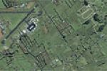
Ardmore Aerodrome (NZAR) in New Zealand uses satellite data to position buildings and implements a precise layout for runways and taxiways, with the surrounding area extending beyond the aerodrome.…
 New Zealand
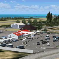
RJKI identifies Kikai Airport in Kagoshima, Japan, and anchors the entry with a geographic reference to the island city, along with an aerial view that accompanies it. Shigeru Tomino of Lets Fly As…
 Japan
Japan
Three locations update to Pensacola Carrier V2.0, including Oceana, Miramar, and Pensacola. NDB KNPC on deck serves both carriers at 245.0 kHz; LOC/DME KNPC 108.15 MHz; VOR PCGA 110.20 MHz, with 80…
United States of America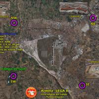
Armilla, Granada, Spain, hosts a base recreation for Ala 78 pilots with a low-detail layout including hangars, a control tower, and a fuel station; a higher-detail variant exists for Ala 78 Virtual…
 Spain
Spain
Two-part patch converts Shehryar Ansari’s FS2004 KLGA layout for New York’s La Guardia into FSX, packaged as klga_FSX with lga2004.zip and lga2004fix.zip. It removes two 2bgl files and adds three b…
United States of America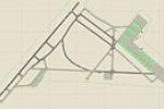
At MacDill AFB (KMCF) near Tampa, a revised layout adds parking spaces, a fire station with trucks, helipads, and static fork trucks, replacing the five main hangars with more realistic ones. It us…
United States of America
By Chris Carel, this freeware project marks the Southern Crossing, designating AP and SP locations across the southern United States, including KYUM Yuma International, KGEU Glendale, KLCH Lake Cha…
United States of America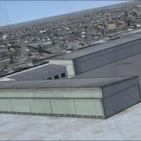
Near Buffalo, New York, the main terminal gains expanded gates, jetways become visible, and a cargo-area section with trucks appears along the apron. A general aviation terminal includes many stati…
United States of America
Ellington Field (KEFD) in Houston, Texas, serves civil operations and hosts the Texas Air National Guard, the Texas Army National Guard, the US Coast Guard, NASA, and UPS. Two files, AFX_KEFD_JC.bg…
United States of America
Vandenberg AFB KVBG near Lompoc, California, receives a refined layout by Jim Cook, featuring reworked taxiways and re-aligned aprons based on AirNav diagrams and Google Earth imagery. Two files, A…
United States of America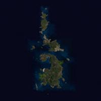
Three water runways lie at Chi-Chi Jima, Torishima, and Ha-Ha Shima, while a naval port on Chi-Chi Jima, a naval facility on Ha-Ha Shima, and a support base on Torishima anchor the area. The presen…
Japan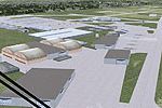
Jim Cook delivers a reworked Hill AFB layout that designates Military_Cargo and Military_Combat parking and adds a fire station. It uses two files, AFX_KHIF_JC.bgl and KHIF_JC.bgl, to implement the…
United States of America
Ian Thatcher provides a modified landclass for the Australian mainland, with Norfolk Island included, and two BGL files designed to align with regional conditions. It revises earlier landclass file…
 Australia
Lambert–St. Louis International Airport (KSTL) receives ADE-based enhancements by Ray Smith that introduce two runway setups and four-runway crosswind operation, with KSTL_ADE_RS.BGL and KSTL_ADE_C…
United States of America
SBCN - Caldas Novas (Zaza v1.0) is an add-on by Rafael Carelli (Zaza), using default objects and real data sources such as Jeppesen, DECEA, and personal photos. It records a 3.42-degree GNSS approa…
 Brazil
An upgrade to WMKJ at Senai, Malaysia uses Airport Design Editor 9x to replace the default layout, adding a terminal with jetways, a cargo terminal, hotels, a hospital, parking areas, a waterfall, …
 Malaysia
Shanard Letang presents a corrected ADEX and BGL for SKCG, noting changes to the fire station. The note confirms SKCG as the location and mentions Cartagena as the setting, while detailing the corr…
 Colombia
A freeware KSGJ asset by Art Poole replaces generic buildings with a custom library and adds a seaplane base with a functional ramp, based on aerial imagery from major map sources. It includes .mdl…
United States of America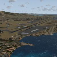
By Kyprianos Biris, this modification of Angelo Tassoglou’s LGAT2B.ZIP documents the closed Athens Hellinikon airport in 2002 after LGAV’s March 2001 opening, with the northwest area used for Olymp…
 Greece