Terminal Procedures

PASY — Eareckson As

SHEMYA, AK · 6 FAA charts · cycle 6 Aug 2026

FAA SYAElevation 97 ft1 runwayLongest 10,004 ftNon-toweredVolume AK-1Not for navigation
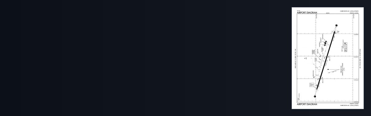
PASY airport diagram — runways, taxiways and ramp layout
PASY airport diagram The official FAA airport diagram — runways, taxiways, ramp layout and hold-short positions. Download PDF

5 published instrument approaches: 1 ILS approach, 2 RNAV (GPS), 2 VOR, serving 2 runway ends.

All 6 PASY charts in one download Every approach, departure, arrival and minimums page for this airport, sorted into folders, as a single ZIP. Taken one at a time on the free tier, 6 charts is roughly 38 sec of downloading — they queue one behind another.
PRO members only

Instrument approach procedures

ChartAmendment
ILS OR LOC/DME RWY 28 chart previewILS OR LOC/DME RWY 28PDF
RNAV (GPS) RWY 10 chart previewRNAV (GPS) RWY 10PDF
RNAV (GPS) RWY 28 chart previewRNAV (GPS) RWY 28PDF
VOR/DME OR TACAN RWY 10 chart previewVOR/DME OR TACAN RWY 10PDF
VOR/DME OR TACAN RWY 28 chart previewVOR/DME OR TACAN RWY 28PDF

PASY airport information

Control tower
No
Attendance
All mon-fri 1800-0300z++ clsd wkend & hol
ARTCC
Anchorage Oceanic Center
Flight service
Cold Bay
NOTAM facility
SYA (NOTAM-D available)
Magnetic variation
1E
Beacon
White-green (lighted land airport), sunset to sunrise
Wind indicator
Yes
Customs
Landing rights airport
Activated
May 1949
Ownership
Privately owned
Sectional
W Aleutian Isls

From the FAA NASR 28-day subscription, cycle 6 Aug 2026.

PASY radio frequencies

ServiceFrequencyCall sign
CTAF127.2

Civil VHF frequencies from the FAA NASR 28-day subscription. Discrete sector and military frequencies are not listed.

Runways

10,004 × 150 ft1028N3,000 ft
Runway layout at PASY, drawn to scale from FAA published runway-end coordinates and true alignments. Runways served by an ILS are highlighted.
RunwayLengthWidth SurfaceLighting
10/2810,004 ft150 ftAsphaltHigh intensity
  10PAPI (4-box) 2.5° · ALSF-1 approach lighting · right-hand circuit
  28LOC/GS · PAPI (4-box) 2.5° · SALSF

Runway and approach-aid data from the FAA NASR 28-day subscription.

Where PASY is

Latitude, longitude52.7122580, 174.1135890
Elevation97 ft

Paste the coordinates into a simulator’s world map to drop straight onto the field.

FAA remarks for PASY

  • THIS AIRPORT HAS BEEN SURVEYED BY THE NATIONAL GEODETIC SURVEY.
  • 352.050 UHF.
  • CUSTOMS UNAVBL.
  • ARFF INDEX 7C
  • HILLS 8 NM W 662 FT MSL.
  • ACTVT ALSF1 RWY 10; SALSF RWY 28; HIRL RWY 10/28 - CTAF. PAPI RWY 10 & 28 OPR CONSLY.
  • 0800-1700.
  • CHRISTINA BOLLE
  • D317-392-3362/C907-392-3362.
  • CTN: 200 FT TURN RADIUS MAX; TOW BAR & PSNL FOR LRG COML ACFT RQRG GTR THAN 200 FT TURNAROUND NA. NO OVERRUN; SHEER DROP OFFS.
  • WITH 25 FT SHOULDERS.
  • CTN: ILLUSION OF HGT & USBL RWY WID PSBL LNDG DURG LOW VSBY & AT NIGHT. NON STD VFR PAT RWY 10.
  • CTN: SEE GENOT/RADIATION AREAS: 52 44-N/174 05-E BEARING 250- 028T.
  • EXTERNAL MOUNTED ELECTRO EXPLOS DEVICE RADIATION HAZ AREA SFC-16000 FT MSL TO 3 NM. PSBL INTFC WITH ELECTRONIC EQUIP ABV 200 FT MSL TO 3 NM MIL/62 NM CIV FM PHASED ARRAY ANT NW CORNER OF SHEMYA IS. PSBL 30 MIN ARRL DELAY FOR ELECTRO EXPLOS DEVICE ACFT. ELECTRO EXPLOS DEVICE ACFT MUST ADVISE AIRFIELD OPS PRIOR TO DEP.
  • FLTS ORIGINATING OUTSIDE THE UNITED STATES REFER TO AK SECTION OF USAF-FOREIGN CLNC GUIDE. 30 MIN PN FOR BARRIER SVC.
  • HVY GOOSE ACTVT APR-JUN & AUG-OCT; GULLS & RAVENS INVOF ARPT. RPT BIRD/WILDLIFE STRIKES ON OR INVOF EARECKSON - EAS AFLD OPS/TWR D317-392-3505/C907-392-3505 & 3WG/SEF & USDA-WS D317-552-4798/4128 OR C907-552-4798/4128.
  • SHEMYA 52 44-N 174 05-E BEARING 250-028T; INFO ONLY.
  • PMSV METRO REMOTE WX BRIEFINGS AVBL H24 - 15 OWS D312-576-9755/C618-256-9755; 2 HR PN.
  • TWY A, D, & PRI HCP CLSD. ALT HCP 72 HR PPR.
  • ARPT HAS RGLR & LED OBSTN LGT; LED LGT MAY NOT BE VSB TO NGT VISION DEVICES.
  • 7 DAY SITE ARR OR 45 DAY FOREIGN NATNL REQ - D317-552-5020/5107/C907-552-5020/5107 & PPR - D317-392-3505/3606/4005/C907-392-3505/3606/4005.
  • SVC FEE RQRD. TSNT SVC MON-FRI 1800Z-0300Z++; CLSD WKEND & HOL. AFT HR MAY INCUR O/T & SVC FEE.
  • CTAF ADVSY 352.05 UNAVBL 0300-1100Z++ MON-SAT, SUN & HOL. AFT SKED ARR CTAF ADVSY 352.05 AVBL ONE HR PRIOR.
  • AIRBORNE ACFT DECLARING EMERG INTO EARECKSON AIR STN - EARECKSON METRO 127.2 OR 352.05 DURG OPS HR; IF NO ANSWER - EARECKSON RADIO ON CTAF & CALL 907-392-3505/3606; ENSURE ANCHORAGE ATC IS AWARE OF EMERG. AS BACKUP ANCHORAGE ATC DURG NON OPS HR SHALL NOTIFY EARECKSON RADIO ON 907-392-3505/3606 OF ALL ACFT EMERG. DURG NON OPS HR EARECKSON AIR STN RQR 30 MIN PN WHEN PSBL.
  • USAF INSTALLATION; CLSD TO CIV OPS. MIL/CIV DECLARED EMERG & IN DISTRESS WILL BE HONORED.
  • WX/AFLD OPS - D317-392-4005/C907-392-4005.
  • COORD ETOP OR AFLD CRITERIA - D317-392-3362/C907-392-3362.
  • UNCTLD ARPT; PRAC APCH, FLEET SVC, CUSTOMS & ACFT MAINT NA. DEICER SAE AMS 1424P TYPE 1 AVBL WITH 1 HR PN.
  • CIVIL ACFT LNDG PERMIT REQ 30 DAYS BFR LDG - D317-552-5282/C907-552-5282.
  • MANNED OBS SUPPLEMENTED BY ASOS 1000-0200Z, MON-SAT, NO SUN OR HOL.
  • RCR/RSC SAME AS ATNDD HR. FICON & RWY COND CODE NOT RPRTD.
  • MANDATORY & INFO SIGNS NOT INSTALLED.
  • C-130/L-100 WT RSTRD MAX 137 KIPS ARR OR DEP VIA TWY B; GTR THAN 137 KIPS USE TWY C & M.

Published verbatim from the FAA NASR subscription. Abbreviations are the FAA's own.

Instrument coverage

Eareckson’s five approach plates serve both ends of its single runway rather than concentrating instrument coverage in one direction. Two RNAV and two VOR procedures, together with ILS and localiser capability, provide several forms of guidance instead of relying on one procedure type. The ILS also gives the chart set a precision approach.

Runway layout

Runway 10/28 provides 10,004 ft for take-off and landing, accommodating aircraft that require substantial runway distance. As it is the only runway, every departure and arrival uses the same strip. The airport diagram adds the ground-layout detail not contained in the approach plates.

Common questions about PASY

What charts are available for PASY?

6 current FAA charts for Eareckson As, including 5 instrument approachs, 1 airport diagram. All are free to download as PDFs from this page, from the 6 August 2026 cycle.

What are the radio frequencies for PASY?

CTAF 127.2. Full civil VHF list, with sector notes, is in the frequencies table on this page — from the FAA NASR subscription.

How long is the runway at PASY?

Eareckson As has 1 runway. The longest is 10/28 at 10,004 ft by 150 ft, asphalt. Full runway dimensions, lighting and approach aids are listed on this page.

Does PASY have an ILS approach?

Yes — 1 ILS procedure is published. In total PASY has 5 published instrument approaches, of which 2 are RNAV (GPS).

Where can I download the PASY airport diagram?

The official FAA airport diagram for Eareckson As is free to download at the top of this page. It shows runways, taxiways, ramp layout and hold-short positions, and is reissued every 28 days.

Is PASY a towered airport?

No — Eareckson As has no control tower. Traffic co-ordinates on a common frequency rather than with a controller, which is listed in the frequencies table on this page.

Are these PASY charts current?

They are from the FAA cycle effective 6 August 2026, which is superseded on 3 September 2026. We publish each new cycle on its effective date. They are for flight simulation and reference only — not for real-world navigation.

Wider chart sets

Bulk archives are a PRO benefit. Individual charts are free for everyone, always.

Flying into PASY? PRO members take all 6 charts as one ZIP instead of 6 separate downloads, at full line speed with no cap — plus every chart family archive and all 24,000+ add-ons in the library.

Go PRO

Not for navigation. For flight simulation and reference use only. Procedures are superseded on a 28-day cycle — obtain current official charts from the FAA for real-world flight.

FAA public-domain products, mirrored unmodified. Fly Away Simulation is not affiliated with or endorsed by the FAA. Chart licensing and terms.
