Page 8
Searches the whole library — filter by sim & category on the results page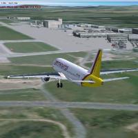
By Nichael Spengler, Dresden Aierport (EDDC) in Germany, realism rises through standard objects and freeware items, aligned with airport charts. The design relies on Airport Design Editor 9_147 and…
 Germany
Designed for a broad Central European nation, this offering spans 93,030 square kilometers and delivers 2 cm per pixel adjustments, with 1 m per pixel textures for major cities such as Budapest and…
 Hungary
Conifer, seasonal, and tropical forest imagery are included, with global coverage and a shift from 1 meter to 30 centimeters in resolution. Only summer imagery is available, and the archive include…
 Global (World)
An MPTO enhancement by Rhett Browning, Version 1.0 released in July 2007, updates Tocumen International to a 2007 appearance with double parking spots and added helipads. It expands the cargo and m…
 Panama
Four BGL files organize updates for O’Hare, including KORD_ADE_RS.BGL for default runway operations, KORD_ADE_CW_RS.BGL for crosswind use, KORD_ADE_CVX.bgl to remove autogen, and KORD_ADE_OBJ.BGL f…
 United States of America
By Ray Smith, ADE Home Edition for the LFMN default airport adds assigned parking, rebuilt support vehicle roads, and extra fuel trucks in the LFMN.BGL file. Airport views come from the roof of the…
 France
In Georgia, at Hartsfield Airport, identified as KATL, the layout adds a 9000-foot runway and activates it for landings and takeoffs, with gates assigned so Delta uses most of them and Air Train ha…
United States of America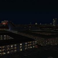
The second and final component upgrades 48 major city autogen structures worldwide, restoring light maps in Paris, Berlin, London and other capitals. Following part one, it covers continents includ…
Global (World)The VHHH facility receives a total makeover featuring assigned parking, extra buildings, a tank farm, extra fuel trucks, and rebuilt support vehicle roads. Designed with ADE utility v1.37 by Ray Sm…
 Hong Kong
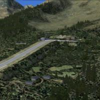
Version 2.0 presents four alpine altiports with sloped runways: LFHM Megeve, LFKX Meribel, LFHU Alpes d'Huez, and LFLJ Courchevel, all authored by Guy Nemoz. The project uses Alps LOD11 freeware me…
FranceADE v1.45 enables a makeover of the EDDM facility, adding assigned and extra parking, extra fuel trucks, a lighted helipad, and rebuilt support-vehicle roads, with central control tower views in to…
Germany
Eduardo Gomes Airport (SBEG) in Manaus, Brazil receives a photoreal depiction authored by Alexandre Vieira. It relies on SbuilderX work by Luis de Sá and uses aerial imagery, with a folder named SB…
 Brazil
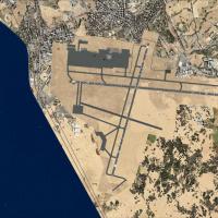
Ray Smith coordinates a DTTA enhancement featuring two main files, DTTA_ADE_RS.BGL for single-runway operation and DTTA_ADE_CW_RS.BGL for dual-runway use, plus DTTA_ADE_OBJ.BGL that supports all 3D…
 Tunisia
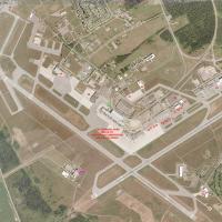
Photoreal depiction of CYOW in Ottawa, Canada, spans all seasons and features 70+ new 3dsmax models with custom lighting that yield high detail. The terminal area derives from Nav Canada documentat…
 Canada
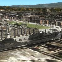
Sixteen 3D models depict the Pompeii ruins and Mount Vesuvius in a high-detail visual representation by Kevin R. Wynn. Pompeii ruin models are used with permission from Peter Olsen, tying the compo…
 Italy
ItalyTen Greek airfields are included, including LGKR Kerkyra, LGKF Kefallonia, LGZA Zakynthos, LGKC Kythira, LGIR Heraklion, LGST Sitia, LGIK Ikaria, LGLM Lemnos, LGPL Astypalaia, and LGKJ Kastelorizo.…
 Greece
Colin Dietrich delivers a rework of Saba Island, producing three .bgl files for two locations: SABA_ADE_CD.bgl, SABA_ADE_CD_CVX.bgl, and saba_newheight.bgl, which raise the airport height to 18m/60…
 Bonaire, Sint Eustatius and Saba
By Lotar Tomczyk and Jakub Mista, this Krakow and Balice (EPKK) area enhancement presents the Old Town square and Wawel Cathedral among its landmarks, while including animated vessels on the Wisla …
 Poland
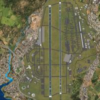
By Ian W, this freeware depiction covers Kadena AB (RODN) and five Okinawa airstrips, naming Yoron Island (RORY), Iejima (RORE), Aguni (RORA), Kumejima (ROKJ), and Kerama (ROKR). A flight plan runs…
 Japan
JapanTwo RS variants exist for Arlanda's upgraded layout near Stockholm, Sweden, with ESSA_ADE_CW_RS.BGL enabling crosswind operations on runway 8/26 and ESSA_ADE_RS.BGL preserving default usage; both r…
 Sweden