Page 28
Searches the whole library — filter by sim & category on the results page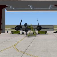
Walker Grant provides a Beale AFB enhancement that adds more objects drawn from the default libraries, including parking lots, emergency vehicles, personnel, and civilian tech reps in hangars. The …
 United States of America
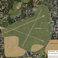
Named by Alf Denham, the enhancement covers Priory Farm X3PF, Walney Island EGNL, and White Waltham EGLM with custom objects and refined layouts reflecting rural and coastal settings. It uses Googl…
 United Kingdom
Dallas/Fort Worth International Airport extends four runways to 13,401 feet, covering 18L-36R, 18R-36L, 17C-35C, and 17R-35L, while other runways remain at their correct lengths; two BGL files acco…
United States of America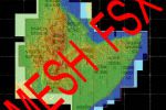
A four-country mesh spans Ethiopia, Erythrea, Djibouti and Somalia, assembled as a Horn region project with LOD 0 to 9. Creator credit goes to Marcel Wislet, and the assembly covers the four nation…
 Global (World)
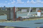
Aimed at enriching Dutch airspace visuals, this update adds three-dimensional urban architecture, bridges and overpasses, wind turbines, and ships and vessels across the Netherlands. The v4.0.32 in…
 Netherlands
Freeware offering enhances visual references across Switzerland for visual flight, drawing on OpenStreetMap data to depict land use, leisure areas, waterways, and rail lines. Created by Markus Frey…
 Switzerland
KLAX.BGL modifies the default layout at the airport serving the city of Los Angeles in California, adding a center taxiway between 25L and 25R and correcting taxiways E17, AA and V along with updat…
United States of America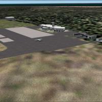
Macapá 2005, identified as SBMQ, presents a freeware variant that faithfully mirrors the airport layout with updated taxiway signage and improved runway markings. By Gustavo Luna, it adds enhanced …
 Brazil
By Antoine Calleja, a second fix for VNKT, Nepal, addresses missing aprons and a strip of asphalt in front of hangars at Khatmandu Tribhuvan Airport, and also corrects light poles at the field to i…
 Nepal
NepalThe airport lies in Aswidnik, 15 kilometers from Lublin's main town, a location within Poland that places it near Lublin; the first commercial landing and takeoff occur on 17 December 2012, credite…
 Poland
An add-on by Jacek Zaczek of ZAQ Technologies covers the Ursynow area of the capital, featuring 3D buildings and photographic imagery across the locale. It ships as the Ursynow3d-v3 folder containi…
Poland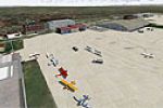
Blackpool Squiresgate in the United Kingdom blends with Horizon GenX Photo content and GenX Mesh, aligning its layout with the surrounding visuals. It includes Blackpool EGNH.bgl for airfield data …
United Kingdom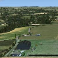
Alf Denham updates three lesser-known UK airfields, including Eggesford (X2EG), Eshott (EG18), and Swansea (EGFH), adding new structures and landclass alignment to reflect local footprints. He reli…
United Kingdom
The set includes four areas—Key West, Key West Docks, Mooney Harbor, and Fort Jefferson—with animated flags scattered throughout. The Key West Docks area adds hardened surfaces for seaplane docking…
United States of AmericaAimed at Kuala Lumpur International WMKK, this upgrade adds gate assignments, cargo parking, and a redesigned road network with extra fuel trucks and enhanced apron lighting. It includes WMKK.bgl a…
 Malaysia
Rick Lackey presents a CYBA variant, relocating the runway and shaping its slope to match the terrain, with objects added. Two BGL files, CYBA_ADEX_RL.BGL and CYBA_ADEX_RL_CVX.BGL, define the layou…
 Canada
Marcos Grinstein features a terrain setup around Curacavi Valley in central Chile, with 1.2 meter satellite imagery, autogen objects, and mesh terrain surrounding SCCV. Two accompanying image asset…
 Chile
Chile
Zakopane Airport (EPZN) in southern Poland remains a fictional facility outside Zakopane, featuring three runaways and an ILS. Two BGL files carry the addition, EPZN_ADEX_AW_CVX.BGL and EPZN_ADEX_A…
Poland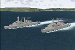
Two destroyer configurations and three frigates are included, each available in both static and AI variants. Destroyer options include Original Fit with Sea Slug and Sea Cat alongside 20 mm mounts,…
United Kingdom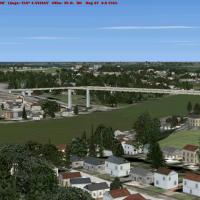
Bridges at the Kiel-Canal in Germany are excluded and replaced by 42 m high spans, matching real-world height. Flatten-polys fill gaps along the canal as well as the Elbe from the sea to Hamburg an…
 Germany