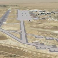
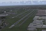
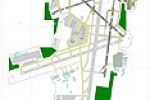
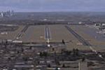
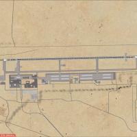
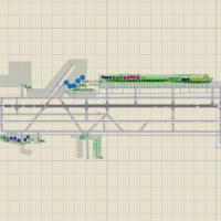
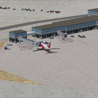
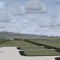
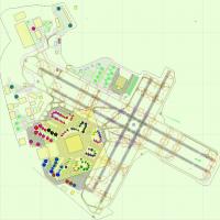
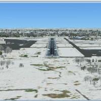
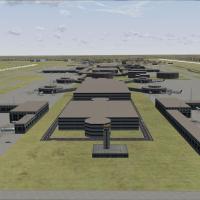
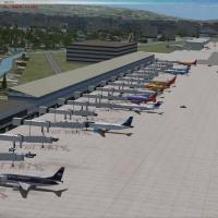
United States of America

Page 15

Sort
Reset
Preview screenshot

Oxnard Airport

KOXR Oxnard Airport for Microsoft Flight Simulator X introduces animated ground support vehicles, variable-intensity ramp lighting, scattered personnel and a few static GA aircraft, all compiled with Airport Design Editor and Instant Scenery; the layout aligns with AI traffic schedules and blends with Ground Environment X textures, Active Sky X weather and Ultimate Terrain USA coverage.

File Size
418.09 KB
Total Downloads
216
Star Rating
4/5
Screenshots
2
Preview screenshot

Casa Grande Municipal Airport

FSX rendition of Casa Grande Municipal Airport (KCGZ) introduces a detailed AFCAD, animated ground service vehicles, custom parking stands and photoreal objects across the Arizona desert apron, accompanied by tuned night lighting and seamless compatibility with MegaCity Phoenix, Ultimate Terrain X, Ground Environment X, Real Environment Extreme and MyTraffic X.

File Size
385.81 KB
Total Downloads
206
Star Rating
3/5
Screenshots
2
Preview screenshot

AFCAD Modification To The Stock KRDU

Raleigh-Durham International Airport (KRDU) for Microsoft Flight Simulator X receives a 2009-era AFCAD overhaul by Kambiz Agazi, adding precise gate allocations, realigned taxiways, updated ILS/RNAV coding, refined cargo and GA aprons, corrected landclass, and adaptive lighting calibrated for AI traffic solutions such as MyTraffic X and WOAI, remaining compatible with FSX SP2, UTX USA, and high-resolution mesh.

File Size
2.33 MB
Total Downloads
201
Screenshots
10
Preview screenshot

Austin Executive Airport

Covering Austin Executive Airport KEDC in Texas, this FSX add-on replaces the obsolete 6R4 layout with a present-day airfield diagram, revised taxiway geometry, corrected runway length, custom AFCAD and a provisional ILS, giving corporate-jet and GA flyers accurate approach fixes and realistic parking positions under the MS Flight Simulator X engine.

File Size
5.54 MB
Total Downloads
200
Screenshots
3
Preview screenshot

Pocono Mountains Municipal

FSX users flying the United States/Pennsylvania set will find Pocono Mountains Municipal Airport (KMPO) represented with an updated airport layout file, 5,001-ft asphalt runway 13/31, revised taxiway geometry, accurate field elevation, EZ-Scenery objects and default GA traffic, enabling credible pattern work and regional VFR routes across Monroe County’s plateau terrain.

File Size
738.75 KB
Total Downloads
195
Star Rating
3/5
Screenshots
2
Preview screenshot

Beverly Municipal Airport

Beverly Municipal Airport KBVY for FSX updates this Massachusetts general-aviation field with re-drawn aprons, straightened taxiways, service roads, expanded parking stands, static vehicles, realistic ramp lighting, and new terminal, hangar, and maintenance models, using only default library objects for smooth pairing with stock landclass, Ultimate Terrain, or FSGenesis meshes.

File Size
11.45 KB
Total Downloads
189
Star Rating
3/5
Preview screenshot

Cornelius-Moore

Polk County’s Cornelius-Moore Airport (4A4) receives a detailed Microsoft Flight Simulator X rendition featuring custom hangars, FBO textures, apron clutter, SAMM-generated static GA traffic and accurate runway markings, modeled from Google Earth data via ADE, Instant Object Maker and the FSX SDK; seamless with default mesh, this Georgia airstrip suits VFR circuits and short cross-country legs.

File Size
23.92 MB
Total Downloads
188
Star Rating
2/5
Screenshots
5
No image available.

Pocatello Midwest B-29 Bases

Pocatello Midwest B-29 Bases scenery for FSX refreshes Idaho’s municipal airport alongside WWII bomber training fields—Fairmont, Bruning, Walker—using revised AFCADs, custom FSDS structures, period hangars, AI-capable parking and calibrated navaids, giving Microsoft Flight Simulator X users accurate historic base layouts across these classic American airfields.

File Size
6.32 MB
Total Downloads
179
Preview screenshot

Connecticut River Bridges

Adds detailed bridge models along the Connecticut River corridor for FSX, aligning with Flight1 UT USA landclass and crafted via Instant Scenery. The single BGL injects realistic span placements near Hartford and Springfield, enhancing VFR navigation, riverbank landmarks and low-altitude sightseeing across central New England while keeping frame rates stable.

File Size
4.98 MB
Total Downloads
177
Star Rating
4/5
Screenshots
23
Preview screenshot

Scenery KISN, ND

Covering Williston’s KISN – Sloulin Field in North Dakota, this FSX scenery package refreshes apron markings, custom terminal geometry and night washes, tuned to Ultimate Terrain USA and FS Genesis mesh for accurate elevations; ideal for regional jet and GA ops among the Bakken oilfield landscape with upgraded landclass and seasonal autogen.

File Size
339.85 KB
Total Downloads
174
Star Rating
3/5
Screenshots
2
Preview screenshot

Arcata Airport

Arcata Airport (KACV) scenery for Microsoft Flight Simulator X refreshes this Northern California field with geo-accurate taxiways, re-profiled runways, and corrected ramp parking based on Google Earth data, blending default FSX library objects. Compiled via Airport Design Editor, the add-on suits regional IFR/VFR operations in the USA index.

File Size
325.01 KB
Total Downloads
174
Screenshots
1
No image available.

Brainard Airport Texture

Hartford–Brainard (KHFD) freeware scenery for FSX realigns hangars, FBO sheds, taxiway geometry and ramp textures, offering sharper ground markings and correct object placement against the Connecticut River and downtown skyline; built with Flight1 Instant Scenery yet standalone, it marries smoothly with UT USA terrain for both VFR circuits and regional IFR departures.

File Size
3.17 KB
Total Downloads
174
Preview screenshot

Terre Haute International Airport

This Microsoft Flight Simulator X scenery upgrade refreshes Terre Haute International Airport—Hulman Field (KHUF), Indiana with refined AFCAD data, corrected taxiway signage, dynamic night ramp lighting, animated ground vehicles, scattered personnel, and static GA plus ANG aircraft, supplying a practical Midwest hub for civil circuits, military training flights, and regional IFR departures.

File Size
432.86 KB
Total Downloads
172
Star Rating
2/5
Screenshots
3
Preview screenshot

Williamson County Regional Airport

Covering southern Illinois’ KMWA, this freeware FSX scenery refines Williamson County Regional Airport with upgraded asphalt textures, corrected AFCAD geometry, hand-placed apron clutter, photoreal terminal façades, region-specific farmland autogen and calibrated LED lighting, giving simmer traffic smoother ILS approaches and accurate ground operations inside Microsoft Flight Simulator X.

File Size
475.28 KB
Total Downloads
170
Star Rating
3/5
Screenshots
2
Preview screenshot

Provo Municipal Airport

This FSX scenery mod installs an air-cargo hangar and associated ground service equipment at Provo Municipal Airport (KPVU), Utah, sharpening freight-handling stands and giving Flight Simulator X pilots a practical launch point for regional cargo hops toward KHOB or KFMN; integrates cleanly with default terrain and AI traffic flow.

File Size
1.38 MB
Total Downloads
169
Screenshots
3
Preview screenshot

AFCAD Modification For Stock KPSP

This United States scenery enhancement overhauls Palm Springs International Airport (KPSP) for FSX, delivering chart-matched RNAV RNP transitions from BALDI to CUPOL on 31L, refined AFCAD gate logic, revised taxiway geometry, authentic apron surfacing, desert lighting ambience, red-strobe tower effect, and optimized parking allocations for AI schedules.

File Size
1.36 MB
Total Downloads
165
Screenshots
8
Preview screenshot

Marana Regional Airport

Covering KAVQ near Tucson, this FSX add-on for Marana Regional Airport refreshes the southwest U.S. airfield with corrected taxiway geometry, revised parking stands, ATIS frequency, dynamic ground traffic, helipad spots and realistic ramp lighting; remains compatible with Ultimate Terrain X, MyTraffic, default AI and Heli Traffic 2004.

File Size
405.81 KB
Total Downloads
165
Screenshots
1
Preview screenshot

Tonopah Airport

Under central Nevada’s basin–range backdrop, this FSX scenery rebuilds Tonopah Airport (KTPH) with GA ramp positions matching satellite charts, apron clutter, perimeter asphalt and dirt access roads, plus sloped-flatten grading that erases the stock mesa anomaly; compiled BGLs integrate cleanly with default mesh or 10 m USA terrain.

File Size
812.99 KB
Total Downloads
163
Star Rating
1/5
Preview screenshot

Richmond Municipal Airport

KRID Richmond Municipal Airport for FSX refreshes this Indiana GA field with custom Instant Scenery-2 buildings, annotated ramp lighting, animated hangar doors keyed to NAV2 112.00 / 116.00, accurate 5,200-ft asphalt 06/24 and 15/33 runways, corrected taxiway lines, F-4C static gate guardian and bundled AI traffic. Optimised for SP2, night textures and seasonal ground polys suit Midwest flying.

File Size
5.1 MB
Total Downloads
162
Star Rating
4/5
Screenshots
2
Preview screenshot

Lewis University

Covering KLOT near Joliet, this Microsoft Flight Simulator X add-on models Lewis University’s airfield and adjoining campus with custom autogen, scale-checked terminal, hangars and a tribute to Grady’s Flight Service, while augmented ILS beams on 09/27 give GA crews a reliable IFR gateway into northern Illinois airspace.

File Size
8.95 MB
Total Downloads
154
Star Rating
5/5
Screenshots
11

55 pages with 1097 downloads.

previous1234567891011121314151617181920212223...5455next