Page 19
Searches the whole library — filter by sim & category on the results page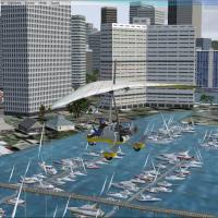
Enhancing FSX’s Honolulu Harbor, this BGL scenery supplements the default Ala Wai basin with static sailboats, moored motor craft, custom dock geometry and low-level gull animations, aligning with …
Covering Medgar Wiley Evers International (KJAN), this FSX add-on renders Jackson, Mississippi’s primary field with a scratch-built terminal, annotated AFCAD gate layout, Air National Guard C-17 ap…
Written for Microsoft Flight Simulator X with Acceleration, this United States listing layers new content onto OzX’s freeware Grand Canyon terrain: rim-edge resort complexes, parking areas, dispers…

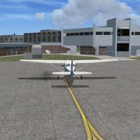
Covering KCRQ McClellan-Palomar, KOKB Oceanside Municipal, L18 Fallbrook Community Airpark, L35 Big Bear City and the private strip OCA8 Ward Ranch, this FSX add-on redraws taxiways, stand position…
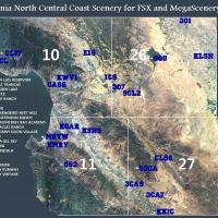
Photoreal coverage of California’s North Central Coast, from Gustine to King City, merges MegaSceneryEarth sectors 10, 11, 26 and 27 with 9.6 m FSGenesis terrain, supplying twenty additional public…
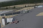
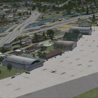
KGRB Green Bay Austin Straubel International Airport for FSX delivers a quiet overhaul of Wisconsin airspace with freshly built FSDS terminals, revised AFCAD gate coding, current Jeppesen procedure…
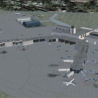
Covering Louisiana’s Louis Armstrong New Orleans International Airport (KMSY), this Alpha India Group AFCAD file refreshes FSX with a scratch-built four-concourse terminal, accurate gate coding, UP…

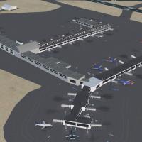
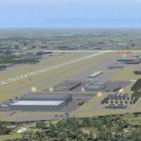
George Bush Intercontinental (KIAH) for FSX refreshes Houston’s hub with updated AFCAD via ADE v1.37, optional crosswind-enabled five-runway operations, realigned taxiway geometry, corrected signag…
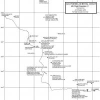
From Paso Robles down to Santa Barbara, this FSX-native enhancement adds 22 geo-referenced landmarks, updated AFCADs for PRB, SBP, SMX, VBG and SBA, reshaped coastlines via Genesis mesh compatibili…
This regional FSX scenery rebuild covers Daytona Beach, Florida—injecting revised landclass data, enhanced photoreal textures, and custom models for KDAB, KEVB, Daytona International Speedway, Main…
Covering Tallahassee Regional Airport (KTLH), this FSX-specific scenery refreshes Florida’s capital hub with revised AFCAD data, current taxiway geometry, photoreal ground polygons, and custom libr…

KPVD scenery add-on for Microsoft Flight Simulator X SP2 updates Providence–Warwick’s terminal geometry with revised gates, functional Ctrl-J jetways, resampled taxiway network, GA parking spots, a…

Covering upstate New York’s KALB, this FSX retrofit by Ray Smith introduces extended Runway 1/19, corrected taxiway geometry, segregated ground-service paths, added ramp parking, optional crosswind…
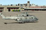
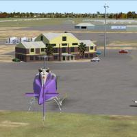
Covering NAS North Island (KNZY) on Coronado, this FSX-only enhancement reworks aprons, taxi paths, and parking charts, adds a fire station with crash tenders, re-sited ATC tower, static Seahawks p…
KGSO Greensboro/Piedmont Triad International Airport scenery for Microsoft Flight Simulator X updates the North Carolina hub with refined AFCAD geometry, current taxiway designators, realistic GA a…
KGJT Grand Junction Regional Airport scenery for Microsoft Flight Simulator X refreshes the default airfield with ADE-crafted AFCAD matching current FAA charts, realigned 11/29 runway data, re-draw…
KPBI Palm Beach International, USA, gains a functional FSX AFCAD refresh via ADE: updated runway identifiers 14/32 and 10L-28R/10R-28L, selectable crosswind logic, corrected ILS frequencies, expand…
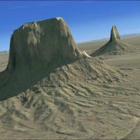
In this beta FSX (Microsoft Flight Simulator X) add-on, Monument Valley’s sandstone buttes along the Utah-Arizona border are rendered with 5 m IFSAR terrain mesh and 1 m photoreal orthophoto textur…
Delaware’s KDOV upgrade for Microsoft Flight Simulator X refines Dover Air Force Base with accurate AFCAD work, expanded Military_Combat and cargo ramps, added general-aviation stands, twin fire st…
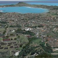
Designed for Flight Simulator X, this Part II Kaneohe Bay MCAF (PHNG) autogen package slots atop MegaSceneryX Honolulu/O‘ahu, injecting photoreal vegetation, shorefront suburbs, marina assets and g…