Page 41
Searches the whole library — filter by sim & category on the results page
This FSX scenery add-on for the United States index depicts Moriarty Sailplane Airport (0E0) in New Mexico’s high-desert plain, presenting photoreal ground textures from USGS imagery, precise runwa…

Anchored in Ohio’s Mahoning Valley, this FSX-only revamp of KYNG Youngstown–Warren Regional Airport supplies correct Allegiant Air stand allocations, functional animated jetways (Ctrl-J ready), rea…
Amarillo International Airport KAMA for FSX depicts the ongoing terminal renovation, features reserved Southwest Airlines parking at gates 31–33, integrates the two Bell Helicopter V-22 Osprey pads…
Watertown International Airport (KART) for Microsoft Flight Simulator X refreshes this upstate New York airfield with revised apron layouts, corrected taxiway geometry, extra GA and commuter gates …
Long Island’s KHTO scenery package for Microsoft Flight Simulator X revises runway headings, reshaped aprons, and corrected taxiway geometry, while custom hangars, perimeter roads, static GA traffi…
Built for Microsoft Flight Simulator X, this FSX scenery download renders Northampton, Massachusetts airfield 7B2 and its Connecticut River valley surroundings with custom library objects, matched …
Hayden–Yampa Valley Airport (KHDN) for FSX gains a practical overhaul with this AFCAD rework: additional terminal gates, widened concrete apron, revised parking designations and optimized taxi link…
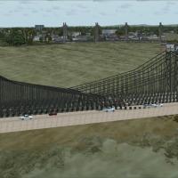
Adds detailed bridge models along the Connecticut River corridor for FSX, aligning with Flight1 UT USA landclass and crafted via Instant Scenery. The single BGL injects realistic span placements ne…
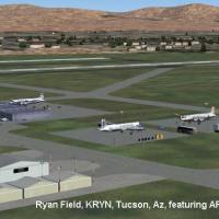
This FSX scenery add-on upgrades Ryan Field (KRYN), accurately positioning the Tucson general-aviation aerodrome with revised taxiway geometry, custom hangars, desert photoreal ground polys, local …
York Airport (KTHV) for FSX refreshes this Pennsylvania general-aviation field with revised apron geometry, realigned taxiways, detailed service roads, replacement terminal and hangar models, plus …
Built on the abandoned WWII Hawes Aux #1 strip east of Edwards AFB, this FSX flight-sim scenery revives the Mojave outpost as Nevada Systems’ UAV hub, blending photoreal desert textures, custom Acc…
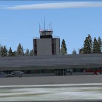
Boire Field (KASH) in Nashua, New Hampshire, United States gains a refreshed AFCAD in this FSX-specific package, replacing default autogen with geo-referenced structures created in ADE9X, adjusting…
Florida’s Goddard Seadrome Seaplane Base (FD46) brings Frostproof’s private water strip to Microsoft Flight Simulator X, adding timber docks, refined shoreline polys, and nav-aids—NDB 277 kHz and V…

Pilots routing through central Pennsylvania will find this FSX rendition of Bellefonte Airport (N96) useful; the add-on supplies a 3,600-ft paved strip at 1,080 ft MSL, updated taxiway layout, cust…
Covering Williston’s KISN – Sloulin Field in North Dakota, this FSX scenery package refreshes apron markings, custom terminal geometry and night washes, tuned to Ultimate Terrain USA and FS Genesis…

Arcata Airport (KACV) scenery for Microsoft Flight Simulator X refreshes this Northern California field with geo-accurate taxiways, re-profiled runways, and corrected ramp parking based on Google E…
Pennsylvania’s Ghost Airports Collection gains Update 2, inserting the long-forgotten Conway aerodrome (identifier PN51) into Microsoft Flight Simulator X via refreshed .BGL scenery, updated screen…
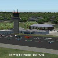
This Microsoft Flight Simulator X scenery add-on revisits Norwood Memorial Airport KOWD, Boston’s southwestern GA reliever, swapping default autogen for geo-referenced structures, corrected runway …
KEWB New Bedford Regional AFCAD refresh introduces accurate Cape Air stands, expanded GA spots, revised hangar footprints, a custom-textured water tower, mapped service roads, vehicle parking and a…

This Microsoft Flight Simulator X scenery upgrade refreshes Terre Haute International Airport—Hulman Field (KHUF), Indiana with refined AFCAD data, corrected taxiway signage, dynamic night ramp lig…