Page 56
Searches the whole library — filter by sim & category on the results page
Two offshore oilrigs near Dubai, with accompanying fuel tanks, a refinery, and an onshore HQ building, feature landable helipads on both rigs and the HQ. An archive provides a C_AddonScenery01 fold…
 United Arab Emirates
Starseed Productions LLC, distributed for Red Eye Guys Inc, provides default coverage for nine airports across the Bahamas and the southern Florida Keys, with BGL files included. The work does not …
 Global (World)
Manching AB (ETSI) sits in southern Germany near Ingolstadt and hosts WTD-61. ADE X 1.50 uses stock objects, and German shelters, the tower, and buildings by Malte Deja and Wolfgang Schroeder popul…
 Germany
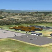
Aeroworx delivers an airfield enhancement for Kruger Mpumalanga International Airport (FAKN) near Nelspruit, combining photo-based imagery of surrounding terrain with carefully aligned elevation da…
 South Africa
Alan Mccarthy presents Charleroi Airport (EBCI) near Brussels, Belgium, as a focused add-on for detailed reference, incorporating geographic fidelity and alignment with mapping sources. The integra…
 Belgium
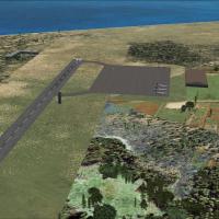
On San Andres Island in Colombia, Gustavo Rojas Pinilla International Airport stands as one of Avianca's hubs to South and Central America. Two BGL files are provided, CVX_Gustavo_Rojas_Pinilla.BGL…
 Colombia
Operating as a compatibility patch, this LLBG Fix renders the LLBG 2006 project, originally designed for an earlier platform, functional in a later environment. It fixes ground visuals and runway t…
 Israel
Five parts comprise a Quebec lakes project, organizing BGL files labeled by NW corner coordinates within the Quebec_Lacs_FSX folder, with separate subdirectories for effects and corrected elevation…
 Canada
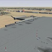
Lee Marrow delivers a freeware adjustment of HLLT, Libya's primary aviation hub, integrating with default libraries and introducing expanded apron spaces, revised ramp configurations, and new cargo…
 Libya
Libya
The listing contains MHLM, La Mesa, San Pedro Sula, and Las Limas airfields, noting four locations and remaining freeware with credit to ferangel2000. An accompanying image depicts an aircraft appr…
 Honduras
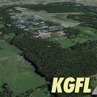
Located in upstate New York, Warren County owns KGFL and RichAir operates it. It features a 5000-foot main runway and serves small-engine aircraft up to a few private jets daily, while the V3 updat…
 United States of America
At Linton-on-Ouse, UKMIL delivers a representative setup that avoids perfect accuracy while delivering a better-than-default feel. No aircraft are included, but the AI version enables flights from …
 United Kingdom
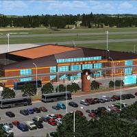
Shigeru Tomino of Lets Fly Association presents RJCB in Hokkaido, Japan, as a focused addition. An aerial view shows the airport and its surrounding area, anchoring the geographic layout and provid…
 Japan
JapanEglin AFB (KVPS) near Valparaiso, Florida receives an enhanced layout with Okaloose Regional Airport added, plus expanded parking, multiple helipads, and more combat and cargo spaces. Two BGL files…
United States of America
Updates affect KDAB, KEVB, KOMN, KDED, and 1FD1 with seaplane dock, Main Street pier, City Island ball park, and Ponce Inlet lighthouse beacon, plus landclass corrections and Embry-Riddle facilitie…
United States of America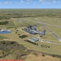
Schleswig-Jagel AB (ETNS) sits in northern Germany near Schleswig and the Baltic coast, hosting Naval Wing 1. It includes Kiel-Holtenau EDHK civil and ETMK military fields, and uses ADE X 1.50 with…
Germany
Reproduces the 2010 aerial race course over Rio de Janeiro with an authentic pylon layout that mirrors the real event. Starting points sit near SBRJ Santos Dumont Airport, and this freeware project…
 Brazil
Version 1.2 adds major roads with moving traffic, power lines, and refined Land Class around San Juan, spanning TJSJ, TJBQ, and TJPS. Two af2x_tjsj.BGL files exist, one for Americal Airlines parkin…
 Puerto Rico
Mike Eppright presents a completely new rendition of KMKC in Missouri, as freeware. The creation relies on GMAX and ScenGenX, and notes that the runway and taxiway layout follows an older template,…
United States of America
Thermals lifts enable glider flights across India, using atmospheric updrafts to sustain longer durations and broaden routing options for cross-country gliding. An image at /userimages/windia.jpg o…
 India
India