Page 11
Searches the whole library — filter by sim & category on the results page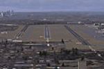
Located in Washington state near Seattle, this add-on expands SEA/TAC by introducing a third runway identified as 34C, supplementing the existing 34L and 34R. It provides published ILS approaches f…
 United States of America
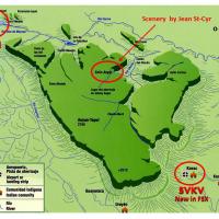
Canaima Airport-SVCN, Angel Falls (created by Jean St-Cyr), and camp Kavak-SVKV (new) comprise the offering, using photo-terrain data from satellite imagery and a terminal building depicted with im…
 Venezuela (Bolivarian Republic of)
Stefan Liebe (EDDS) presents a KJRB heliport in downtown Manhattan near Wall Street as a frame rate friendly addition. Buildings for heliport structures are sourced from a flight-simulation library…
United States of America
Hay River, CYHY in the Northwest Territories sits on the southern shore of Great Slave Lake, and the layout aligns the airport with NAV Aids. GMax-built buildings use photographic imagery, while st…
 Canada
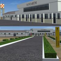
Santarem Airport in Brazil carries the SBSN designation and presents version 1.0 with taxiway signs. By Gustavo Luna, this freeware project highlights the SBSN code and the Santarem airport, preser…
 Brazil
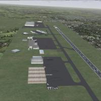
By Lee Marrow, this UK airfield project for code EGNX uses stock FSX objects and adds cargo on the ramp. Parking slots expand and ground activity increases, while compatibility with stock FSX objec…
 United Kingdom
openVFR collaborates with Markus Freyt to bring Germany POI data sourced from OpenStreetMap, enriching low-altitude navigation with forests, farmland, built-up areas, and landmark references. The p…
 Germany
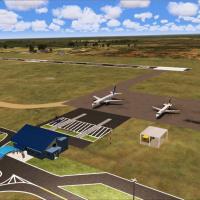
Eduardo Mello credits the SWSI 3D project version 1.3, focused on Sinop Airport (OPS, ICAO SWSI) in Mato Grosso, Brazil, with coordinates derived from mapping data. It uses DDS files with mipmaps a…
Brazil
Version 9 replaces all earlier versions and includes news, upgrades and corrections to some Chilean airports, with attention to the mainland–Robinson Crusoe route, by Juan Lucero. This revision ref…
 Chile
Chile
Version 1 presents heliport facilities for two adjacent cities in the Strait of Gibraltar, with each heliport handling a regular passenger line, by Bernardo Barroso. Two accompanying JPG images ill…
 Spain
Spain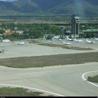
Located on Margarita Island, the SVMG aerodrome features two terminals for domestic and international flights, with most traffic between Margarita and Caracas, and is named Aeropuerto Internacional…
Venezuela (Bolivarian Republic of)
Buenos Aires 2008 by Pablo Contouris centers on the end of the Paraná delta and a coastal strip from Escobar to La Plata, balancing performance with a realistic land appearance. It references the B…
 Argentina
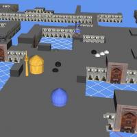
The Imam Reza shrine in Mashhad, Iran, appears in version 1, created by Usof Kalantari and based on real photographs. Two BGL files are provided, enabling the 3D shrine depiction, with the project …
 Iran (Islamic Republic of)
Two BGL variants orient at KPBI in West Palm Beach, created by Ray Smith, using ADE by Jon Masterson. KPBI_ADE_RS.BGL keeps conventional runway patterns while KPBI_ADE_CW_RS.BGL activates runway 13…
United States of AmericaBaiyun International Airport (ZGGG) is updated by Ray Smith with a terminal expansion and the E3 and W3 concourses, plus a FedEx hub served by new taxiways and signage. Three BGLs—ZGGG_ADE_RS.BGL, …
 China
China
An enhancement of McGuire AFB (KWRI) near Wrightstown, New Jersey, adds extended parking with lighting, a fire station, and realigned aprons and taxiways that mirror reference diagrams and imagery,…
United States of America
The St. Eustatius depiction centers on the FD Roosevelt airport TNCE in the Caribbean. It uses SbuilderX, Autogen Annotation, and Airport Design Editor 9x, and boat traffic may appear from source f…
 Bonaire, Sint Eustatius and Saba
Trabzon LTCG airfield and its surrounds in the eastern Black Sea region of Turkey present a VFR depiction with realistic object placement and autogen, along with photoreal elements supplied with Go…
 Turkey
World's shortest commercially serviced runway defines this airport rendition, which adds gates and a realistic terminal with animated people, and includes one static plane stationed for refueling a…
Bonaire, Sint Eustatius and Saba
Liege airport in Belgium gains cargo ramp additions and more parking slots, a layout by Lee Marrow for cargo-focused operations. The approach relies on compatibility, maintaining alignment with exi…
 Belgium