Page 101
Searches the whole library — filter by sim & category on the results page
KBKL in Cleveland, Ohio, sits beside Lake Erie as a general aviation airport. Custom 3D structures with photo-real surfaces rise around the field, while static aircraft rest on the ramp and support…
 United States of America
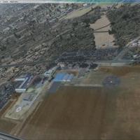
Located in central Poland, Plock Airport (ICAO EPPL) serves the Mazowiecki Flying Club, featuring grass runways 13/31 at 680 by 300 meters and 08/26 at 550 by 250 meters, plus a Mi-2 rescue helipad…
 Poland
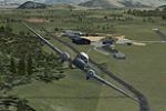
Authored by Kade Bellaney, this enhancement for Wanaka Airport NZWF in Otago, New Zealand, uses a custom airport facility data file and ADE 1.45 to refine parking spots and runway headings, while i…
 New Zealand
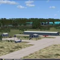
Located in Collier County, Florida, Everglades Airpark sits on a 29-acre site near Everglades National Park and Big Cypress National Preserve, with custom hangars and buildings built to integrate w…
United States of America
An enhanced variant centered on KSEA adds a third runway and expands the artificial plateau, with landclass updates around Seattle-Tacoma. It includes AFX_KSEA_AW.BGL, KSEAOBJ.BGL, and SEATACLC.BGL…
United States of America
Airfields in the Namibian north include Grootfontein, Ondangwa, Rundu and Katima Molilu, built from standard base elements and paired with four bgl files: AFX_FYGF_ALT.bgl, AFX_FYOA_ALT.bgl, AFX_FY…
 Namibia
The airfield serving the Lake Toba area is identified by the code WIDT and sits within Indonesia's Lake Toba region. By Ikhsan Ramadhan Ritonga, the description identifies the Lake Toba site and it…
 Indonesia
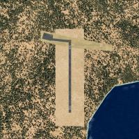
Flight plans accompany the three Aer Arann Islands BN2s, and parking changes affect four airports with tower frequencies for each. Tractors, hangars, and small terminals populate the environment, a…
 Ireland
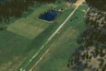
An Idaho private mountain airstrip, Pavel Korpos, offers a freeware package compatible with default mesh and landclass, including small_airstrip_objects_ss.zip and a set of bmp textures plus a .bgl…
United States of America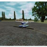
North Bay’s Jack Garland Airport (CYYB) gains maintenance parking and a new building, with the previously closed 13/31 reopened as a grass airfield and a water strip for seaplanes. A helipad, GA pa…
 Canada
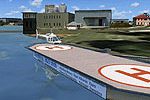
Two helipads sit on a single pontoon along the Yarra River in Melbourne's central business district, labeled YWTC World Trade Centre Helipad and YYBK Yarra Bank Helipad. By Anthony Lynch, Vol 3 in …
 Australia
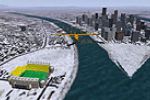
Three Pittsburgh venues—Heinz Field, PNC Park, and Mellon Arena—receive an original design by Camilo Forero for a 2004 default package, with Ray Lunning credited for repositioning the objects for u…
United States of AmericaA fictional GCJD airport on Fuerteventura maintains three runways, two measuring 2000 meters and one 3000 meters, all with ILS capability. It provides 69 spaces for heavy, medium, and cargo operati…
 Spain
Spain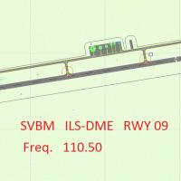
The setup centers on Jacinto Lara International in Barquisimeto (ICAO SVBM), detailing an ILS beacon object library positioned to the right of runway 09. It remains compatible with any mesh and car…
 Venezuela (Bolivarian Republic of)
Clearwater Airpark, adjacent to KCLW, receives a refined ground layout with updated taxiways, refined aprons, and newly placed hangars. The package includes Airport_Buildings_AP.bgl and integrates …
United States of America
An add-on for flight simulation locates Harrowbeer in Buckland Monachorum, Devon, inside Dartmoor National Park, about nine miles NNE of Plymouth and six miles south of Tavistock, under 10 Group. S…
 United Kingdom
A BGL file places a completely fictional aircraft carrier west of Los Angeles near KLAX, and Derek Souza credits it, with Blue Angels numbers 1 through 3 parked on the deck as a surprise for enthus…
United States of AmericaKarl Meindl authors the CV69 fix, which replaces the older CV-71 setup and includes only an updated install text for CV69.ZIP. It instructs deleting three bgl files—CarrierCV.bgl, ADE_CV71.bgl, KNP…
United States of America
Smith Graphics introduces the KLBB project for Lubbock Preston Smith International Airport in Texas, dating to 2008, with an auto-install program named Project_KLBB. By Smith Graphics, the KLBB lis…
United States of America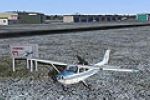
Mascouche airport, identified as CSK3, sits in Quebec, Canada, and has all real buildings plus a runway oriented to a new configuration; Sylvain Tremblay is credited. A Cessna is parked nearby on t…
Canada