Page 118
Searches the whole library — filter by sim & category on the results page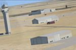
KAUS in Texas receives an ADE 9X-based update that reworks ramps, taxiways, and runways to align with current charts and imagery, adds FBOs, and updates the terminal with correctly numbered gates, …
 United States of America
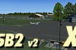
A reworked ADE fix for a New York airfield in Saratoga County corrects parking spot links and ensures AI traffic navigates to and from designated spaces. It relies on 5B2_X_V2.ZIP by Ed Cox and 5B2…
United States of America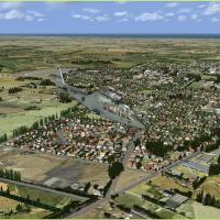
Ashburton airfield in Canterbury anchors a New Zealand photoreal environment, with full autogen detail and a setting between Christchurch and Timaru. It is designed and recommended for Vector Land …
 New Zealand
Loire-Atlantique on the Atlantic coast of western France hosts an ULM Base with the LF4451 identifier at Frossay, lying near the Loire river and serving as a travel-focused waypoint for exploration…
 France
KDBQ in Dubuque, Iowa remains FSX SP2 compatible, updates gates and parking to align with current airlines and the cargo ramp. The project uses ADE, adds a repair hangar, FBO office, a new terminal…
United States of America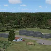
Custom objects and default libraries form a South Africa airfield representation for general aviation in the surrounding area. Credits go to Jacques Botha and Frits Beyer, and the FALO folder and t…
 South Africa
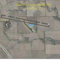
KEDC facility in the Texas capital replaces the former Birds Nest (6R4) as industrial development progresses, and an ILS is added for landing ease, by Jimmy R. Martin. The arrangement centers on a …
United States of America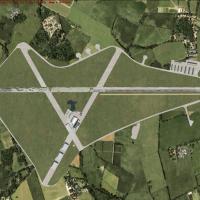
Turweston Aerodrome (EGBT) sits in the East Midlands, UK. The package includes three BGL files and three DDS files from tcd_egbtxv1.zip, uses stock EGLL data, and applies refinements with Scruffy D…
 United Kingdom
Custer County Airport KCUT sits in Custer, South Dakota, USA, with objects drawn from a flight-simulation library. Airport Design Editor by Scruffy Duck shapes its layout, and the project integrate…
United States of America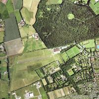
Neumuenster airfield (EDHN) sits in Schleswig-Holstein, northern Germany, a small aeroclub field near the Kiel autobahn. By Uwe Schweitzer, it stands as a modified version of the former EDHN VFR la…
 Germany
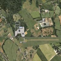
Klein Muhlingen in Germany carries ICAO code EDOM and serves as an addon that corrects aprons and adds taxiways and objects. The airfield primarily hosts sail planes and light aviation, with sparse…
Germany
Grassthorpe Grange airstrip serves Neil Birch’s Microlights users, located near Newark in Nottinghamshire, and is authored by Neil Birch for this community. It uses files from all four volumes, plu…
United Kingdom
Collingwood-area project CNY3, authored by Andrew Barter, sits near Blue Mountain Resort, Scenic Caves, and Wasaga Beach in Ontario, using default and EZ Library objects to place ground layouts and…
 Canada
KMPO, operated by Pocono Mountain Municipal Airport Authority, sits near Mount Pocono in Monroe County, Pennsylvania. It features a paved runway 13/31 extended to 5001 feet by 75 feet and sits at a…
United States of America
An aviation addon presents a fictional airfield in the French Alps near Courchlevel, France, featuring a compact runway, a single hangar with parking, and a helicopter pad, all in freeware form, by…
France
Phillip Coyle provides two BGL files, KRDD_ADE.BGL and KRDD_ADE_CVX.BGL, for Redding, California, with real-world dimensions derived from mapping data and a northeast parking ramp added beyond the …
United States of America
In Minas Gerais, Brazil, Vazante Aerodrome (SNVA) fills a missing airfield in the default layout. Jose Maia handles authorship, and the GIF vazantex.gif accompanies the listing, which confirms SNVA…
 Brazil
Mandeville, near Gore in New Zealand's Southland, sits with Croydon Aviation Heritage Trust and Croydon Aircraft Company Ltd, which specialize in De Havilland aircraft. This freeware project is for…
New Zealand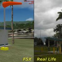
Bocono Airport (SVBK) in Venezuela sits at 5085 feet, the highest airfield in the country, and supports VFR flights with a very dangerous approach. It includes a terminal building, control tower, h…
 Venezuela (Bolivarian Republic of)
Two BGL files, KSBP_ADE.BGL and KSBP_ADE_CVX.BGL, anchor an add-on for San Luis Obispo's airport (KSBP) created by Phillip Coyle. Airport Design Editor compiles the files, and default library objec…
United States of America