Page 16
Searches the whole library — filter by sim & category on the results page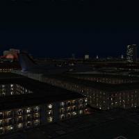
The second and final component upgrades 48 major city autogen structures worldwide, restoring light maps in Paris, Berlin, London and other capitals. Following part one, it covers continents includ…
 Global (World)
Version 1.02 targets AB, BC, and AK mountain regions, employing a batch process that copies and renames existing imagery for these areas. It reduces desert tones, adds more rock, and lowers white s…
Global (World)
Miles Hanna delivers seven Swiss airfields, including St. Stephan (LSTS), Saanen (LSGK), Locarno (LSMO), and Buochs (LSZC), with updated airport details across rural Switzerland and the Alps, along…
 Switzerland
Ray Smith presents a Budapest LHBP modification designed with ADE v1.47 that updates the default airport layout, adds assigned parking, extra fuel trucks, and rebuilt roads with updated taxiways an…
 Hungary
Two BGL files, PHNL_ADE_RS.BGL and PHNL_ADE_CW_RS.BGL, update PHNL using ADE v1.37. The CW_RS variant activates crosswind runways, enabling all runways for takeoff and landing, while the RS file us…
 United States of America
Italy-based flight environment includes 12 airports plus a Malta bonus, totaling 13 destinations. The Italian offering, by J. D. Starseed, is distributed by Red Eye Guys Inc and ships multiple BGL …
 Italy
Italy
Eduardo Gomes Airport (SBEG) in Manaus, Brazil receives a photoreal depiction authored by Alexandre Vieira. It relies on SbuilderX work by Luis de Sá and uses aerial imagery, with a folder named SB…
 Brazil
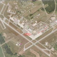
Photoreal depiction of CYOW in Ottawa, Canada, spans all seasons and features 70+ new 3dsmax models with custom lighting that yield high detail. The terminal area derives from Nav Canada documentat…
 Canada
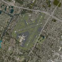
Two BGL variants exist for KFLL, KFLL_ADE_RS.BGL and KFLL_ADE_CW_RS.BGL, designed for the default airport and created with ADE v1.37. The CW_RS version activates the Xwind crosswind runway, while t…
United States of America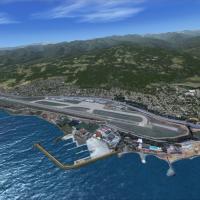
By Sunay Kilic, a LTCG airport depiction uses FSDS 3.5.1 and FSDSXTweak 2.8, featuring a new domestic terminal, an afd file, and multiple LODs. Realistic surroundings with corrected coastlines and …
 Turkey
Barra Beachport presents a beachside airstrip with three runways signaled by red poles, a small terminal, and two ramps, where DHC 6 Twin Otter operations occur mainly at low tide. It restores corr…
 United Kingdom
Poland's EPMO designation marks Modlin Airport, presented at version 1.0, as a new hub north of Warsaw. The site sits 35 kilometers from the city center and targets three million annual passengers,…
 Poland
Five-part series, by Aime Leclercq, compiles 50cm_interzone_01.zip through 50cm_interzone_05.zip, consolidating all components. It defines intermediate zones between mountains and forest from 1m to…
Global (World)
Version 3.0 fixes the DME issue and renders jetways visible and operable, with CNTRL-J enabling calls to the jet, and adds a new terminal and tower while updating gates for Southwest, US Airways, D…
United States of America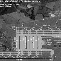
The Berlin Brandenburg project near Schönefeld, Germany, places a midfield terminal between two runways and targets an initial capacity of up to 30 million passengers, with expansion via satellite …
 Germany
Located near Oslo, Norway (ENGM) is modeled using ADE v1.47 for the baseline layout, aligning the control tower, gates, and parking in corrected order, and updating taxiways and signs. Three BGLs—E…
 Norway
Ten Greek airfields are included, including LGKR Kerkyra, LGKF Kefallonia, LGZA Zakynthos, LGKC Kythira, LGIR Heraklion, LGST Sitia, LGIK Ikaria, LGLM Lemnos, LGPL Astypalaia, and LGKJ Kastelorizo.…
 Greece
KHOU in Texas receives a detailed ground layout featuring a new Y-shaped central concourse and the original 1940 terminal, with real gate assignments and runways aligned to satellite imagery. An op…
United States of America
By John Ball, this enhancement for LEVC in Spain is built with ADE 9x and requires no extra modules. It extends runway 12/30 and closes 04/22, adds a displaced threshold and 1000 ft stopways, intro…
 Spain
Spain
Ontario, Canada-based project focuses on downtown Toronto around CYTZ, updating landclass and the airport layout with runway, taxiways, and parking changes. It relocates city buildings and replaces…
Canada