Page 31
Searches the whole library — filter by sim & category on the results page
At Dane County Regional Airport, the package refines the taxiway layout, adds terminal-area parking and gate codes, and places GA parking at several locations. It fixes boundary issues with a flatt…
 United States of America
The Garimpo do Juruena Airstrip sits in Mato Grosso, Brazil, amid the jungle near Alta Floresta. Coordinates are S09 07.72 and W058 32.64, and an unofficial VPGJ designation is provided to aid navi…
 Brazil
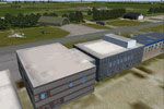
NL2000 v4.03 add-on recreates the base at Leeuwarden in Friesland with custom ground polygons and updated taxiway configurations, designed to integrate into the NL2000 v4 framework. It relies on th…
 Netherlands
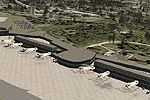
Jim Cook delivers an updated depiction of Islip’s airport, reshaping taxiways, aprons, and the terminal area to mirror real-world layouts. Animated jetways at commercial stands accompany a relocate…
United States of America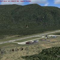
Castlegar Airport in British Columbia receives a patch by P. Nigel Grant that adapts Vern Opperman’s CYCG_V2.ZIP for use with cyxc04.zip. The accompanying archive supplies four bgl files to place i…
 Canada
Woensdrecht base appears in the NL2000 v4 lineup, detailing apron layouts and essential facilities to mirror real operations. It relies on the v4.0.32 installer and aligns runway coordinates and or…
Netherlands
Rotterdam The Hague Airport is added to the Version 4 series, with the NL2000 v4.0.20 installer for proper integration. It delivers custom terminal facades, photo-real surface imagery of runways an…
Netherlands
The airfield sits near La Llagonne at the edge of the Pyrenees in France, offering rough terrain beside a large lake and a region rich in thermals. Registration is LFNQ, and it is not compatible wi…
 France
Lake Hood's area near Alaska gains added hangars, animated floatplanes, docks, buildings, and land vehicles, by Daniel Kemmer. It uses Lakehood.bgl and Lakehoodparking1.bgl, and viewers see full de…
United States of America
Ray Smith delivers a revised KMKE representation, featuring expanded runways, added gates and a functional jetway system, plus a helipad and refined roadways. Two crosswind-capable variants exist a…
United States of America
Two configurations render Lahr (EDTL) with enhanced facilities, including a variant aligned for standard terrains and another for the VFR Germany environment. Peter der Ostfriese and Jürgen Seidel …
 Germany
OpenStreetMap-based data drives a Netherlands-focused POI project that populates roads, railways, waterways, land use, and natural elements for detailed navigation across the country. Created by Ma…
Netherlands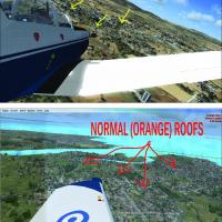
By Vassilis Kostoulas, the work corrects blue rooftop tones observed in Greek settings, replacing them with orange roofs to reflect a regional color shift. It notes the mediterranean_east area and …
 Greece
Situated in the Vendee region of western France along the Atlantic coast, the airfield features grass and asphalt runways and welcomes general aviation and parachute events. By Dominique M. L. Donz…
France
A model of Patoka AO-9 sits at anchor as a mooring mast docking platform across five geographic locations, with airports MPAO Panama Roads, KNAO Pensacola Bay, KAPO Narragansett Bay, VGAO Old Plant…
 Global (World)
Angers-Marce LFJR v4, created by Theo Madzou, centers on Angers-Marce Airport in France and its surrounding area. It includes the airfield and nearby terrain, while noting that the tanker car and p…
France
Philiadelphia International Airport (KPHL) in Pennsylvania gains numbered gates and assigned airline codes, reflecting its operational layout. The addition includes a UPS ramp along with cargo, air…
United States of America
Eyguieres/Salon Airport (LFNE) has two grass runways and a short landing strip that suits gliders, with tower control; Daniel Louvet gives visual references because radio navigation equipment is ab…
France
An addon brings Lupepau'u International Airport to life with a detailed layout for NFTV, Tonga, located 75 nm north of NFTL and 173 nm from NFTF. It is designed for SP2 without Acceleration and use…
 Tonga
Tonga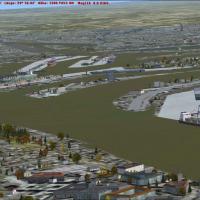
Elbtunnel in Hamburg, northern Germany, corrects the default layout by removing an erroneous bridge across the Elbe River where the tunnel sits. It measures 8 lanes and 426.5 meters in length, dati…
Germany