Page 44
Searches the whole library — filter by sim & category on the results page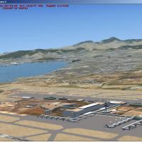
Toni Agramont renders the Balearic Islands of Spain in full detail for VFR and tourist flights. It includes 230 towns and seven monuments such as Cartuja of Valldemosa and Monastery of Lluc, and ai…
 Spain
Spain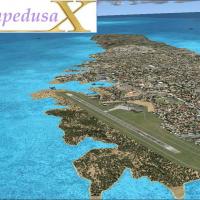
Situated in the Province of Agrigento, Sicily, Lampedusa Airport carries ICAO LICD and dates to 1968 after political intervention; Airone and Air Italy operate 737-300 flights from LICD to LICC, LI…
 Italy
Italy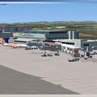
Cardiff Airport (EGFF) in the UK gains a refreshed layout with the north-side terminal added, reflecting a modernization effort led by Stewart Haworth and supported by Jon Masterson's ADE programme…
 United Kingdom
By LJLJ2012, SST - Slovenia Team presents Jozef Puchnik International Airport near Spodnji Brnik with a layout including a valley landclass under approach paths to runways 12 and 30 and three overl…
 Slovenia
Suvarnabhumi VTBS near Bangkok is modeled with taxiways, runways and terminals positioned from Google Earth imagery. The airfield features ILS on both runways and maintains 100% AI-traffic compatib…
 Thailand
Quebec City 2.0 presents more than 135 custom buildings and animations across key landmarks such as Chateau Frontenac and Parliament, with the CYQB airport by Gilles Boily and Montmorency Falls cab…
 Canada
Six Papua Indonesia airports are represented, including Bandara Sentani, Jayapura; Wamena Airport, Wamena; Mopah, Merauke; Nabire Airstrip, Nabire; Frans Kaisiepo, Biak; and Moses Kilangin, Timika.…
 Indonesia
This Galapagos-focused presentation includes SEST, SEGS, and SEII, with visuals mostly stock enhanced by a handful of library objects. Fred Guerra contributes the work, designed to depict an island…
 Ecuador
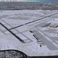
A refreshed MSP airport facility in Minnesota (KMSP) adds runway 17/35, along with expanded taxiways and signs that guide AI movement on approach paths. ILS/LOC equipment and programmed approaches …
 United States of America
By SWVA1369 (Rob Touchtone), this KBWI enhancement realigns gates to reflect current airline allocations and updates cargo ramps with airline-specific codes, while jetways remain fully operable via…
United States of AmericaNorman Manley International Airport in Jamaica is v1, with ILS added to runway 30 and ILS on runway 12 fixed. The work is compiled with ADE by Owen Golding Jr., and reflects the v1 configuration.
 Jamaica
On Fair Isle, the aerodrome is owned by the National Trust for Scotland and operates under a CAA Ordinary License for public passenger transport, not licensed for night use. The single gravel runwa…
United Kingdom
Stand-alone modification to the LEBL data reflects charts dated August 2012, adding ILS to runway 02 with frequency 108.750 MHz and two VOR/DME beacons at 115.350 MHz and 113.150 MHz, plus four pub…
Spain
John Ball presents a London City Airport representation for EGLC in the UK, featuring a new over-dock apron and updated parking areas linked by a taxiway to the runway. ADE9x-based, it uses five EG…
United KingdomDB FlightSim and David Birch design this high-altitude site that sits in Tibet’s remote wilderness as the world’s highest airport, with the longest public runway, a stark landscape framing every ap…
 China
China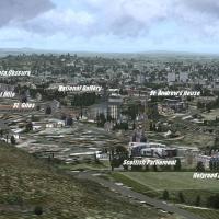
By Martin Reiffer, the enhancement gathers 14 landmarks for Edinburgh, including Holyrood House, the Royal Mile, and Waverley Station, with each object drawn from a public 3D model repository and a…
United Kingdom
An environment rebuild for Rarotonga International blends original objects with newer assets and includes a separate landclass file that markedly reduces the over-forested appearance. It runs with …
 Cook Islands
A patch resolves ground layout red spots and corrects minor tree placements on the airport surface for improved alignment. Requires Lebor Simulations OLBAX V1.0 and installs OLBAX_Layout.bgl and OL…
 Lebanon
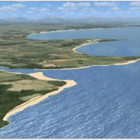
Hannes Steyn and Johan van Wyk of Aeroworx lead a version 2 freeware enhancement spanning South Africa, Mozambique, Namibia, Botswana, Zimbabwe, Swaziland, adding refined road networks, power lines…
 Global (World)
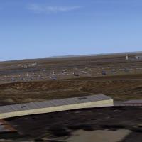
KMHV Mojave area gains a photo-based enhancement built on MegaScenery Earth California data for KHMV Mojave, while preserving the default airport and using only objects from the default folders. It…
United States of America