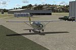
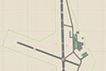
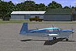
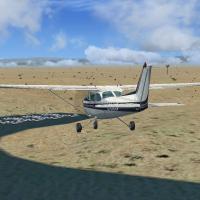
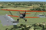
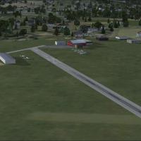
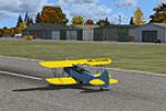
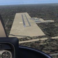
United States of America

Page 53

Sort
Reset
Preview screenshot

Crosswind Runways For CCC

This FSX add-on refines the California Central Coast package by injecting Jim Vile–style crosswind logic into updated AFCADs for SBA, SBP, SMX, PRB, C80 and ancillary strips, enabling AI to select every runway in variable winds; optimized for MegaSceneryEarth terrain and built with ADEX for seamless U.S. regional flying.

File Size
194.95 KB
Total Downloads
88
Screenshots
1
Preview screenshot

Painted Post Airport

Painted Post Airport (7N1) for FSX refreshes this up-state New York strip with accurate asphalt, relocated 03/21 runway, full-width taxiways, edge lighting, centerline markings, a GA apron, hangars, static Cessnas and service vehicles, plus selective tree clearing—an unobtrusive upgrade built solely with stock assets for seamless integration.

File Size
15.53 KB
Total Downloads
88
Preview screenshot

Oneonta Municipal Airport

Upstate New York’s Oneonta Municipal Airport (N66) lands in FSX via this freeware add-on from Jim Cook, replacing stock assets with custom BGL buildings, GA ramp markings, static aircraft and service vehicles, runway 6/24 ground polys and corrected parking nodes built through AFX and Instant Scenery; fully compatible with default Microsoft Flight Simulator X libraries, no third-party mesh required.

File Size
5.16 KB
Total Downloads
88
Star Rating
1/5
Preview screenshot

Weed Airport

Covering Weed Airport (O46) in Siskiyou County, this FSX scenery adds RWY12-based hangars, updated taxiway markings, photoreal ground polys and corrected field elevation, aligning with default mesh for Northern California VFR and IFR circuit practice while remaining compatible with Acceleration, SP2 and AI traffic flows.

File Size
1.08 MB
Total Downloads
87
Star Rating
1/5
Preview screenshot

Blue Canyon Wind Farm

In Microsoft Flight Simulator X, Blue Canyon Wind Farm Phase 1 slots just north of Lawton, Oklahoma, placing fully animated turbine arrays atop the Wichita foothills while refreshing Jennings Ranch strip (OL09) with updated ADE ground polys; compiled BGLs align with Ultimate Terrain X for seamless night lighting and accurate elevation.

File Size
335.66 KB
Total Downloads
87
Screenshots
2
No image available.

AFX File For KPSP

United States scenery entry refines Palm Springs International Airport (KPSP) for FSX, supplying an updated ADE-built BGL with revised aprons, extra parking stands for AI traffic, corrected service-road routing, added fuel units, and a realistic tower viewpoint, bringing the desert gateway’s ground layout in line with current charts.

File Size
11.09 KB
Total Downloads
84
Preview screenshot

CCFSXMS Missing Texture

This United States scenery entry details the CCFSXMS Missing Texture add-on, a focused fix that reinstates accurate grass rendering at Hearst Castle within the California Central Coast Megascenery Earth environment for FSX; the included GRASS10 bitmap replaces the black turf artifact left after the 2009 release.

File Size
43.54 KB
Total Downloads
84
Preview screenshot

Cherokee County Regional Airport

FSX pilots receive a concise scenery add-on for Cherokee County Regional Airport (KCKP) in Cherokee, Iowa, delivering corrected grass-strip geometry, hangar offsets aligned with Ultimate Terrain X roads, static people and objects, a functional ATIS, improved pads and balanced night textures—suited to VFR general-aviation circuits across the American Midwest.

File Size
444.19 KB
Total Downloads
83
Star Rating
2/5
Screenshots
2
Preview screenshot

Hamilton Municipal Airport

Refines Hamilton Municipal Airport (KVGC, formerly H30) in upstate New York with fresh AFCAD parking for light aircraft, a swapped-out terminal, extra aprons, taxiway adjustments and discreet static aircraft / vehicles, all drawn from default FSX libraries for broad compatibility; built using Flight1 AFX and Instant Scenery, aligned to AirNav data and Google Earth for accurate coordinates near Colgate University.

File Size
6.63 KB
Total Downloads
83
No image available.

Hidden Lake/Table Rock

Covering Hidden Lake (2HDL) on Montana’s glacial foothills and the historic Table Rock plateau strip (KTBL) above Medford, this FSX scenery add-on adds custom AFCADs, corrected ARP data, shoreline vectors and accurately placed windsock objects, suiting bush pilots, STOL practice and WWII carrier-pattern touch-and-go sessions across rugged United States terrain.

File Size
8.22 KB
Total Downloads
83
No image available.

Independence Municipal Airport

Independence Municipal Airport KIIB Iowa scenery for FSX updates the Midwest airfield with a 5,500-ft × 100-ft asphalt runway, new terminal hangar, full-length parallel taxiway, refreshed parking ramp, and corrected navaid data, giving general-aviation flyers photoreal grounds and precise AFCAD geometry for circuit training.

File Size
8.84 KB
Total Downloads
82
Preview screenshot

Floyd Bennett Memorial Airport

FSX rendition of Floyd Bennett Memorial Airport (KGFL) in Glens Falls, New York refines the US regional airfield with revised aprons, realistic taxiway geometry, updated parking stands, corrected runway striping, added land-side details such as a flagpole, static GA aircraft and service vehicles, employing default Microsoft Flight Simulator X library objects.

File Size
7.05 KB
Total Downloads
82
Preview screenshot

Songlo Vista (3AK3)

Songlo Vista (3AK3) freeware scenery gives Microsoft Flight Simulator X SP2 pilots a remote Alaskan private strip featuring updated gravel runway textures, corrected elevations, refined terrain mesh, six GA spawn pads, and custom approach data capturing the tall ridges, short-field operations, and changeable weather patterns bush flyers expect in the Kenai backcountry.

File Size
7.97 MB
Total Downloads
80
Screenshots
23
Preview screenshot

Pueblo Reservoir

Covering southern Colorado’s Pueblo Reservoir in FSX, this United States scenery add-on supplies hand-placed autogen and bespoke models for the north/south marinas, Juniper Breaks, Arkansas Point campgrounds, the concrete dam with plume splash-back, ranger huts, fish hatchery, cottonwood clusters and the roadside water tower, enriching VFR navigation around Pueblo West.

File Size
821.69 KB
Total Downloads
80
Star Rating
1/5
Screenshots
3
Preview screenshot

Canandaigua Airport

Reworked D38 Canandaigua Airport for FSX refreshes the upstate New York GA field with corrected taxiway geometry, resized aprons, swapped stock autogen for custom-picked default structures, operational PAPI on 16/34, plus static GA aircraft and support vehicles—built with Flight 1 AFX and Instant Scenery for a tidy, frame-friendly upgrade.

File Size
17.27 KB
Total Downloads
80
Preview screenshot

Mohawk Valley Airport

Revamps FSX’s Mohawk Valley Airport (K13) in Scotia, New York with corrected runway geo-referencing for Ultimate Terrain X, refined gravel access roads, parking stands, custom fuel point, static GA aircraft and vehicles, plus accurate hangar footprint. Uses only stock BGL assets, assembled via Flight1 AFX and Instant Scenery using AirNav and Google Earth references.

File Size
7.87 MB
Total Downloads
80
Star Rating
4/5
Screenshots
23
No image available.

Pemberton Airport

FSX rendition of Pemberton Airport (3N7 / 3NJ1) in New Jersey sets a small 14-acre private strip one mile northwest of town onto MegaScenery Earth photoreal ground, supplying a correctly aligned 22-04 runway, seasonal vegetation, static GA tie-downs under 50 ft span, wind sock, no fuel, unlit VFR pattern, plus ADE-based layout employing EZ Scenery, RWY12 and OZx assets for authentic taxi-edge objects.

File Size
1.12 MB
Total Downloads
79
Star Rating
5/5
Preview screenshot

Watts-Woodland Airport

Reworked Watts-Woodland Airport (O41) for FSX aligns runway geometry, adds the western taxiway and adjacent hangar-home zone using Google Earth footprints, delivering refreshed AFCAD/BGL data built with Airport Design Editor and referencing default library assets; aimed at sim pilots wanting accurate California general-aviation scenery without additional dependencies.

File Size
308.01 KB
Total Downloads
79
Screenshots
1
Preview screenshot

Oak Springs Farm

This FSX freeware scenery adds Oak Springs Farm (private identifier ME-PRV) near Newburg, Maine, featuring hand-drawn four-season texture sheets by Jim Boynton, refined landclass blending, custom autogen tree lines and a short turf runway suited to STOL and light GA circuits—ideal for relaxed VFR hops out of Bangor International.

File Size
3.01 MB
Total Downloads
79
Screenshots
3
Preview screenshot

Kutztown Airport

This FSX add-on reopens the decommissioned Kutztown Airport N31 in Pennsylvania, United States, supplying hand-placed runway markings, rebuilt hangars, the historic fly-in diner, updated AFD files, functional night lighting and blended farmland autogen, suiting VFR general-aviation circuits throughout the Lehigh Valley and wider southeast-PA GA corridor.

File Size
114.62 KB
Total Downloads
78
Star Rating
2/5
Screenshots
1