Clement Roy provides RNAV approaches for Ottawa/MacDonald-Cartier International Airport, Ontario, in a file named AFX_CYOW.bgl, intended as a supplement for flight simulation use and not intended f…
 Canada
Ray Smith reshapes gate layouts by resizing and reorganizing positions and adds parking for larger aircraft, with refined cargo areas. Ray Smith rebuilds ground support roads to keep maintenance tr…
 United States of America
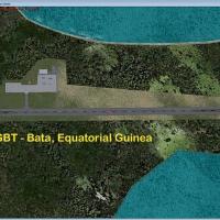
Two variants cover Bata Int'l with different mesh setups, including a default version and a second for a terrain mesh addon that lowers the airport elevation and nearby terrain. Runway numbering sh…
 Equatorial Guinea
S.A. Walton provides AFX files for Manchester International Airport (EGCC) and offers alternate configurations for the UK aerodrome and its surrounding airspace. A Manchester Airport logo appears, …
 United Kingdom
An ADE improvement modernizes Perranporth Airport with a WWII-era control tower, two hangars, and expanded apron spaces for added AI, plus static aircraft around the field. The package comprises tw…
United Kingdom
An AFX file by Michael Meier for Basel-Mulhouse Airport (LFSB) adds ILS to Runway 34 and updates runway layout and lighting. It adds a displaced threshold on RWY34 of 882 meters and places a PAPI a…
 France
Adelaide International Airport, Australia, gains a revised parking arrangement aligned with Airservices Australia charts and Google Earth, authored by Alexander Czarnecki. ADE v.1.47.07 enables its…
 Australia
Dunedin Airport in New Zealand is documented by Kai P. Kamjunke and stands as the final entry in a seven-airport series. A complete collection of airports is set to become available at the end of N…
 New Zealand
At New Bedford Regional Airport, a KEWB adjustment replaces the default hangars with realistic structures and adds a fuel truck and static aircraft. Six Cape Air (KAP) parking spaces sit on the ram…
United States of America
Dusty Bizub identifies KELP in Texas as his 15th project, emphasizing corrections to numbering and AI codes. The note ties to the airport's geographic position and aims to refine identifiers used b…
United States of America
Jonathan K. Hougaard delivers a precise adjustment for Stauning Airfield in Denmark, aligning stand locations and airfield geometry with real coordinates using Google Earth data and Danish AIP sour…
 Denmark
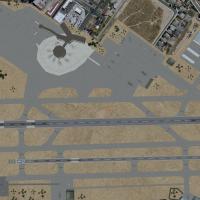
This modification updates Palm Springs International Airport with revised gate allocations and new ramp positions, including two jetway-equipped gates, plus refined runway markings and a flashing r…
United States of America
Mfuwe International Airport in Zambia marks version 1, credited to Bashir Ismail. It includes FLMF.bgl and FLMF_cvx.BGL along with Airport_Buildings_AP.bgl for integration, and notes the upgrade to…
 Zambia
Paraparaumu (NZPP) in New Zealand bears the code NZPP and adds parking, terminals and hangars to the area’s aviation layout, by Nicholas Cole.
New ZealandUnalakleet, Alaska, PAUN (UNK) layout crafted by David Wooddell uses Google Earth imagery, aerial photos, and firsthand viewing to place twenty parking spots for Pen Air, Bering Air, Hagland Air an…
United States of AmericaLeverkusen, Germany, sits on the eastern bank of the Rhine, halfway between Cologne and Düsseldorf, anchoring this item’s geographic scope. Ralf Maylin provides the location context, while Jon Mast…
 Germany
Two BGL configurations exist for the KORF layout, standard KORF_ADE_RS.BGL and crosswind KORF_ADE_CW_RS.BGL, with the latter enabling parallel and crosswind runways for departures and arrivals. Ray…
United States of AmericaKRNO, a Nevada airport, gains a single .bgl file that adds all gates at the facility, with gate assignments derived from aerial photos and a 2003 Reno site image, by K. Troutman. The file uses a .b…
United States of AmericaColin Dietrich adds airline codes to parking areas in the Domestic and International terminals and lengthens the GA runway 8-26C, while a new two-way taxiway provides an extra exit from the south r…
Canada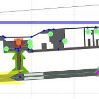
Jonathan K. Hougaard delivers a Sindal Airfield (EKSN) adjustment that realigns aprons, taxiways, and runways using high-resolution imagery and official Danish references for accurate ground layout…
Denmark