Page 95
Searches the whole library — filter by sim & category on the results page
At KSTS in Santa Rosa, California, two BGL files named KSTS_ADE.BGL and KSTS_ADE_CVX.BGL are prepared using Airport Design Editor to depict taxiways, runways, and access routes to CDF Fire Tankers.…
 United States of America
Monte Alto in Sao Paulo state, Brazil, receives a freely available photoreal representation authored by Gilson Cirino. Two images show aerial views of the town, while freeware tools such as Sbuilde…
 Brazil
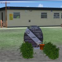
Old Buckenham airfield in Norfolk, UK, preserves a US Wartime bomber base heritage, with a monument to the US 453 Bomber Group in front of the tower, and now serves as a flying school with parachut…
 United Kingdom
Located around Davenport, Bettendorf, Moline, and Rock Island, it replaces default with a new passenger terminal modeled after the real facility and adds the John Deere, Elliott Aviation, and U. S.…
United States of America
Canouan Island's airfield features a single runway 13/31 and remains tower controlled, with an NDB available by runway 31, and the apron supports various types from single and twin engines to up to…
 Saint Vincent and the Grenadines
An enhanced KNIP layout adds parking, a fire station with trucks, an extra hangar, and more static vehicles while revising taxiways and aprons. Two base files, AFX_KNIP_JC.bgl and KNIP_JC.bgl, impl…
United States of America
Uwe Schweitzer presents a Telgte airport layout for VFR Germany 1, with an option to select Munster-Telgte or EDLT after installation. The project relies on Abacus FS-Design, Adobe PhotoShop, and S…
 Germany
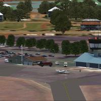
Uwe Schweitzer presents a Carnarvon Airport image-based rendition for west Australia, including photo imagery and an AFX component with night lighting. Autogen relies on libraries from OzX and ORBX…
 Australia
Scotty Berge presents a WWII airfield rendition centered on RAF Molesworth, designated as USAAF Station 107, later HQ for the 41st Combat Bombardment Wing from 1943 to 1945. Two BGL files bear the …
United KingdomHarlingen, Texas airport gains a new main terminal with jetways, plus corrected airline parking for Sun Country, Southwest, and Continental, and two cargo areas for FedEx and UPS; two BGL files sup…
United States of America
Creators Lets Fly Association and Shigeru Tomino present Aeroflex-Andover Airport (12N) in New Jersey, United States. The listing specifies the location by code and credits two contributors, establ…
United States of America
Thorney Island RAF (EGYT) appears in Volume 1, preserving the airfield and domestic buildings as they stood when the airfield closed in 1974. Optional files add West Thorney village, autogen trees,…
United Kingdom
In Idaho’s Orofino area, the S68 airport is represented with photoreal terrain and ground polygons that adjust with the seasons. Many objects incorporate bump mapping, and Kobbe Farwick of Real Sce…
United States of America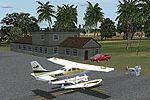
Version 2, by Mike Lanza, updates Duncan Town MYXY with a 500 ft extension and 25 ft widening, adds six ramps, a fuel pump, a helipad, and lights, plus a terminal with tower and customs; Nurse Cay …
 Bahamas
Version 4.0 places a naval layout about 60 nautical miles west of Miramar MCAS, featuring carriers, cruisers, and destroyers with arrestor cables and deck choppers. LOC/DME marks Carrier1 CAT II 10…
United States of AmericaEight dirt-strip airfields across Western Australia carry the codes YA01, YA04, YA05, YA06, YA10, YA15, YA17 and YMUL, including Mylup Fly in Estate near Esperance and Abrolhos Islands west of Gera…
AustraliaAt OIMM in Iran, the v3 update upgrades hangars and nearby structures and introduces a heli site there. The update, credited to Usof Kalantari, changes runway numbers to new figures, and enhances t…
 Iran (Islamic Republic of)
Westkapelle's EBKW heliport, located in West Flanders, Belgium, is offered for helicopter-centric flights. Weygantt Kurt crafts the EBKW site for rotorcraft operations, expanding regional coverage …
 Belgium
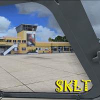
Andres Ramirez creates a focused representation of Vasquez Cobo Airport, identified as SKLT, serving Leticia in Amazonas, Colombia. Two accompanying visuals exist, including a primary image and a m…
 Colombia
IATA TRE and ICAO EGPU identify Tiree Airport, located 2.5 nautical miles north-northeast of Balemartine on the Inner Hebrides off Scotland, owned and maintained by Highlands and Islands Airports L…
United Kingdom