Page 110
Searches the whole library — filter by sim & category on the results page
A GMAX model presents a 100-foot illuminated star atop Mill Mountain, overlooking Roanoke, Virginia and the KROA airport, at lat 37 15.0685 lon -79 55.9602, dating from 1949. Three concentric stars…
 United States of America
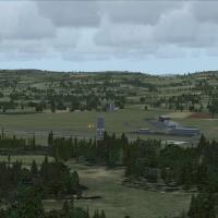
Perth/Scone in the United Kingdom gains a fictional airfield expansion, extending Runway 03/21 to 4500 feet with 1500-foot TDZ markings. A new small terminal at the 03 threshold serves BAe146-size …
 United Kingdom
KMRY, the airport in California, receives a v2 revision tied to MONTEREYAIRPORTKMRYVERSION2.ZIP, addressing two missing hangars and windsock animation issues. The fix responds to reports that the w…
United States of America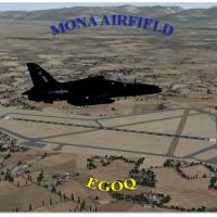
Mona Field, ICAO EGOQ, sits on Anglesey in Wales and serves as a relief landing ground for RAF Valley. Its history traces to 1915 as a Royal Naval Air Service airship base, and today a civilian fly…
United Kingdom
Sunay Kilic provides an ILS beam heading fix for Samsun Carsamba, designated as LTFH, in Turkey, packaged as LTFH09X.ZIP. The correction targets the Samsun Carsamba (LTFH) runway approach and align…
 Turkey
Chicoutimi's CYRC depicts a delta-pattern three-runway layout and an NDB approach, with an enhanced apron and parking area housing multiple buildings and nearby wildlife serving as a visual landmar…
 Canada
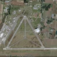
The project reworks Abbotsford International Airport (CYXX), British Columbia, using ADE v1.39 with satellite imagery; runways 01/19 rise to 5328 ft and 07/25 to 9600 ft, with corrected thresholds …
Canada
By Pierre Mogenet, these additions extend a Madagascar bush airfields network with 150 sites across three installments, and include AF2 files to support general aviation traffic with two parking pl…
 Madagascar
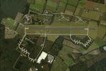
EHDP De Peel airfield, credited to The Netherlands 2000 Scenery Design Team, sits in the southeastern Netherlands and integrates with the NL2000 v4.0.20 environment. It adds hangars, flight-line sh…
 Netherlands
An enhanced version of Williamsport Regional Airport (KIPT) in Pennsylvania tightens aprons and taxiways, replaces the terminal and most buildings, and adds parking lots, static vehicles, lightpole…
United States of America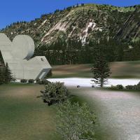
In the Haute Savoie region of France, a WWII-era site sits at 1440 m elevation and lies about 11 miles from Annecy-Meythet (LFLP) airport, with a course of 77 degrees from runway 04. An optimized v…
 France
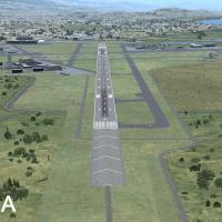
Revision 3 updates SBA and SBP airports to reflect runway and taxiway improvements, with Al Wheeler as the author. The archive lists eight BGL files including KSBAAPLC.BGL and KSBPAPLC.BGL, plus AF…
United States of America
An airfield addon near Preston includes six BGL files plus support materials, designed to blend with Horizon GenX Photo Mesh, and an optional AI control file. The list includes Samlesbury X4PS.bgl,…
United Kingdom
Blackbushe Airport EGLK receives a fictional UK expansion featuring a 6500-foot Runway 08/26 with a 500-foot displaced threshold and ILS approaches to both ends. A south-side taxiway serves a new a…
United Kingdom
Stephane Gouzon authored LFBS, v1.0, and crafted it with ADE, SbuilderX, and Whisplacer. The LFBS - Biscarrosse folder anchors the Biscarrosse airfield location 65 km southwest of Bordeaux in Aquit…
France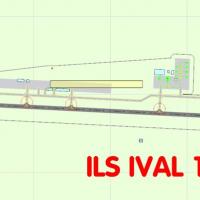
By Alexander Garzon, a single bgl file adds a new ILS to the default SVVA Valencia airport in Carabobo, Venezuela. The file targets the SVVA layout, introducing instrument guidance for the runway a…
 Venezuela (Bolivarian Republic of)
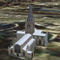
Chesterfield Parish Church, created by Chris Brown, stands 228 feet to the tip of the Crooked Spire. Its tilt is attributed to green wood by inexperienced craftsmen, and coordinates appear at N53 1…
United Kingdom
Two BGL files create displays across Island, San Juan, Skagit, Snohomish, and Whatcom counties, with sites such as Oak Harbor, Friday Harbor, Bellingham, and Anacortes marked for July 3 or 4; some …
United States of AmericaAn enhancement for Northern Maine Regional Airport at Presque Isle, ME, known as KPQI, adds detailed elements to the airfield and relies on artistic license, with Curtis Weeman credited as the auth…
United States of America
Dick Kittredge creates a Westover AFB rendition, adding hangar placements and large cargo ramps around the field, with runways aligned to real coordinates and enhanced vegetation near flight lines.…
United States of America