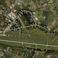
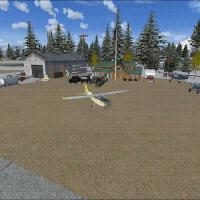
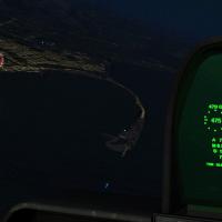
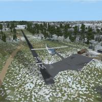
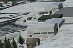
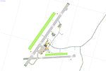
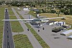
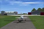
FSX Scenery

Page 139

Sort
Reset
Preview screenshot

Anahim Lake

By Arnaud de Saint Hilaire, the CAJ4 variant centers on Anahim Lake in British Columbia as a fictitious airstrip. The CAJ4 folder serves as the key container for this locale, tying the location to its CAJ4 code.

Country
Canada
File Size
8.18 KB
Total Downloads
111
Star Rating
1/5
Preview screenshot

4 Seasons Photo Texture

North Branch, Antrim, New Hampshire hosts a photorealistic depiction of Hawthorne College’s former campus landscape. The northbranch.bgl file provides a space in the trees and a subtle 3D effect at higher altitudes, by Jim Boynton.

Country
United States of America
File Size
6.78 MB
Total Downloads
111
Screenshots
1
Preview screenshot

Lane Airpark T54

Rosenberg, Texas hosts Lane T54 airpark, growing from a lone runway into an airpark, adds end turning points, a grass taxiway, a repositioned runway, field edge lighting, fuel tanks, hangars, trees, and static vehicles, with a fence placed at the appropriate location and no taxiways on the apron.

Country
United States of America
File Size
1.17 MB
Total Downloads
110
Star Rating
1/5
Screenshots
1
Preview screenshot

J-B Golf

Six shipping containers accompany the J-B Golf, repackaged with no changes to the files. bgL and txt go to the addon area, bmp goes to the addon image area, Farmington, California, marks the geographic scope; Originals by Heath Wells.

Country
United States of America
File Size
2.49 MB
Total Downloads
110
Star Rating
1/5
Screenshots
6
Preview screenshot

Penn Valley Airport

KSEG sits in Selinsgrove, Pennsylvania, along the Susquehanna River in the Susquehanna Valley. Local pilots offer flight instructions and daily rides to surrounding towns, while the airfield emerges under new ownership after budget constraints, by Alan D. Griswold.

Country
United States of America
File Size
1.14 MB
Total Downloads
110
Screenshots
1
No image available.

Daniel Field

Located near Augusta, Georgia, Daniel Field (KDNL) lies roughly nine miles north of Augusta Regional (KAGS). Two .bgl files accompany the project, and the field remains active with around 70 general aviation aircraft daily, serving as the base for the local Civil Air Patrol squadron.

Country
United States of America
File Size
15.41 KB
Total Downloads
110
Preview screenshot

Auburn Municipal Airport

Phillip Coyle crafts an add-on for the KAUN field in Northern California's Gold Country region that aligns the airfield with real-world data using Google Earth imagery. He shapes two BGL files, KAUN_ADE.BGL and KAUN_ADE_CVX.BGL, with Airport Design Editor to adjust runways, aprons, and taxiways for improved navigation.

Country
United States of America
File Size
270.82 KB
Total Downloads
110
Screenshots
1
Preview screenshot

Qalat Airstrip

Qalat Airstrip in Zabul Province, Afghanistan (OAQA) is created from scratch using an Afghan airfield diagram, featuring a landing strip and a hammerhead parking with three spots. Location and orientation are accurate, and it stands as the first airstrip in the province, serving aid flights to Kabul and ISAF personnel.

Country
Afghanistan
File Size
11.88 KB
Total Downloads
110
Star Rating
1/5
Preview screenshot

Tumbler Ridge

By Bob Caparoula, CBX7 identifies a Tumbler Ridge location in British Columbia, Canada, and the work is freeware. A single .bgl file handles geometry, the asset remains frame-rate friendly, and CBX7 can be selected as a starting point for quick access.

Country
Canada
File Size
899.52 KB
Total Downloads
110
Screenshots
1
Preview screenshot

Charallave Airport

Charallave in Venezuela, near Caracas, centers on the Oscar Machado Zuloaga Airport and Charallave-Internacional del Centro. It adds a genuine approach ILS ITUY SVCS with an audible and light middle marker, and adjusts the runway 10 airfield pattern to favor the right-hand configuration.

Country
Venezuela (Bolivarian Republic of)
File Size
684.98 KB
Total Downloads
109
Screenshots
1
No image available.

Flying W Airport

The N14 airfield near Lumberton, New Jersey spans 170 acres. It serves small to medium GA aircraft and helicopters, offers 100LL and Jet-A, and carries a Runway 1 caution about 89 ft trees 262 ft from the runway and 169 ft right of center, with hclib1.zip among external object files.

Country
United States of America
File Size
805.26 KB
Total Downloads
109
No image available.

YPJT

YPJT at Jandakot, Perth Airport, in Western Australia, features added parking and more realistic buildings, by Frank Salter. It requires Rwy12 object libraries. Two ADE files exist, one without and one with fuel trucks, with the non-truck version preferred when busy.

Country
Australia
File Size
22.62 KB
Total Downloads
109
Preview screenshot

NL2000 V4 EHTW Active

Within the NL2000 v4 framework, the EHTW Active module, by The Netherlands 2000 Scenery Design Team, re-creates Enschede Airport Twente as a military air base with a functioning layout. Depicts high-detail ground overlays, terminal facilities, and hardened shelters, and requires the NL2000 v4.0.20 installer for setup.

Country
Netherlands
File Size
59.21 MB
Total Downloads
108
No image available.

NL2000 V4.0 Photoscenery Object Excludes

NL2000 V4.0 fotoscenery excludes files that remove default objects in the Netherlands when used with the NL2000 v4 installer. The Netherlands 2000 v4 layout is modular and free, covering the Netherlands, with attribution to contributors.

Country
Netherlands
File Size
45.2 KB
Total Downloads
108
Preview screenshot

Hideaways - Blake Island

By Jim Beall, the Blake Island site in Washington fixes invisible trees at the end of runway 15 and adds extra visual cues to ease the pucker factor after landing. A BGL file named HideAways Blake Island BGL is included.

Country
United States of America
File Size
239.26 KB
Total Downloads
108
Screenshots
2
Preview screenshot

Sumter Municipal Airport

IATA SMS and ICAO KSMS identify a Sumter-area airfield in South Carolina, serving Sumter and Sumter County with multiple runways; the longest paved strip extends 5500 feet and the field sits at 183 feet elevation about four miles from the city.

Country
United States of America
File Size
439.65 KB
Total Downloads
107
Screenshots
5
Preview screenshot

Anson County Airport

In Wadesboro, North Carolina, JD Sceneries models the local airfield (KAFP) with the Triangle Brick factory across the railroad. A 2005 upgrade replaces a 3,466 by 50 ft runway (17-35) with a 5,500 by 100 ft facility (16-34); by 2008 crews demolish the old strip and construct a parallel taxiway plus a 2,400 sq ft terminal.

Country
United States of America
File Size
9.52 MB
Total Downloads
107
Star Rating
2/5
Screenshots
6
Preview screenshot

Saratoga County Airport

At the airfield 5B2 near Saratoga Springs, New York, by Jim Cook, the revision adds aprons, parking, and buildings alongside static planes and vehicles. The rework corrects runway markings, includes a flagpole, and relies on standard objects with no extra libraries required.

Country
United States of America
File Size
7.48 KB
Total Downloads
107
Star Rating
2/5
Preview screenshot

Madison Municiple Airport

Madison Municipal Airport (KMDS) in South Dakota gains lighting enhancements for the grass runway, improved overall illumination of the buildings, and an ATIS, credited to Jimmy R. Martin. Background imagery relies on Paint Shop Pro, Real Environment Extreme, FS Genesis terrain mesh, and Ultimate Terrain X USA, with object libraries listed for download.

Country
United States of America
File Size
1.39 MB
Total Downloads
106
Screenshots
11
Preview screenshot

Modified Airports

Airports modified and created for a flight simulator include Aquatica (WET2), Eden Hollow (EDEN), Highasara (Ve44), and Gamal Abd El Nasser (HL67). Two extra airports receive additional ILS systems by Highas, while Airport Design Editor guides the builds under input from Fudge Panter and Airmedic-69, with testing by Hotzoner.

Country
Global (World)
File Size
660.36 KB
Total Downloads
106
Screenshots
3