Page 21
Searches the whole library — filter by sim & category on the results page
Using 3ds Max from scratch, it presents accurate buildings, hangars, and parking bays with night lighting. The model includes static aircraft and animations and uses photo-real terrain, and the air…
 Bangladesh
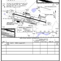
Fortaleza's SBFZ in Brazil depicts version 1.0 with changes to runway 13/31 and taxiways, including centerline lighting, illuminated touchdown zones, and PAPI for RW 31. Ground chart SBFZ and parki…
 Brazil
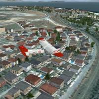
The LTBA area for VFR operations around Istanbul Ataturk adds realistic houses and trees, highway traffic, and landclass improvements near the airport. It requires ISTANBUL.ZIP and works with the d…
 Turkey
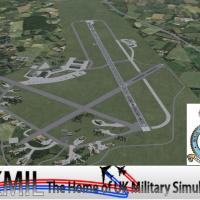
Hawk AI aircraft with custom flight plans and an AI Tornado ADV by Fernando Martinez operate around RAF Leeming in North Yorkshire. The layout maintains alignment of runways, taxiways, and aprons t…
 United Kingdom
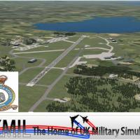
UKMIL presents Kinloss for FSX, a representative add-on that is not true to life in every respect, by UKMIL. It adds a new multi-LOD Nimrod AI aircraft with flight plans, designed to improve the fe…
United Kingdom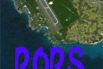
Kenichi Ochiai presents a Japan-based Shimojishima-focused project under the RORS label, with a visual element linked in the accompanying media. The work concentrates on the locale and carries a si…
 Japan
Japan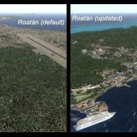
Overhauls Roatan (MHRO) and Guanaja (GJAJ/MHNJ) airfields, adds AI-enabled Utila (MHUT), Fort Cay (MHFC), and Cochino Pequeno (MHCP), and modifies La Ceiba (MHLC) and Puerto Lempira (MHPL) to accep…
 Honduras
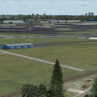
KDAL airport in Texas introduces v1.5, with Southwest gates 1–15, Continental at 26–27, and American functions at 30–32 including AAL, AALX, and EGP, plus extensive GA parking and a Business Jet Ce…
 United States of America
Tempelhof in Berlin, Germany, identified as EDDI, stands as a 2.0 iteration authored by Alexander Helmbold, reflecting the ongoing development of the project. It remains a test version bearing know…
 Germany
Two versions of the EFHK upgrade support crosswind runway activation and a default configuration, coded EFHK_ADE_CW_RS.BGL and EFHK_ADE_RS.BGL. Ray Smith designs the BGL files using ADE Home Editio…
 Finland
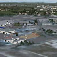
Zimbabwe’s Harare airport, Africa, shows a complete custom layout with terminals, hangars, and admin buildings surrounding a photoreal base that shifts with the seasons. Harare_FVHA folder and the …
 Zimbabwe
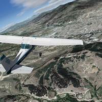
Extensive 1m/pixel coverage spans the country, delivering depth across its varied terrain from plains to highlands and valleys. The package adds 25 GB of changes across 25,713 km^2, detailing farml…
 North Macedonia
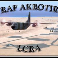
Royal Air Force Station Akrotiri on the Mediterranean island of Cyprus uses IATA AKT and ICAO LCRA identifiers and sits 10 km south-southwest of Limassol within the UK sovereign base area of Akroti…
 Cyprus
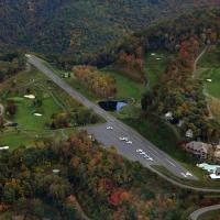
Registration 2NC0 designates Mountain Air as a private airstrip, signaling its identity to pilots and collectors. It sits at 4400 feet in elevation, tucked amid Appalachian Mountains and noted for …
United States of America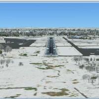
Teterboro in New Jersey sits across the Hudson from midtown Manhattan, functioning as a general aviation reliever with no scheduled airline service or aircraft over 100,000 pounds. Version 2.0, cre…
United States of America
Eight named bases form a Bahamas-focused seaplane collection by Chris Carel, including Bahamas_West, Conch_Bay, Cutlass_Bay, Deadmans_Cay, Exuma_Intl, Marsh_Harbor, Nassau, and Treasure_Cay. The pr…
 Bahamas
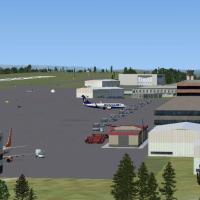
The airport near Bristol, code EGGD, receives a revised layout with a new cargo terminal and expanded overflow parking, and an increased presence of fuel trucks. Created with ADE and credited to MG…
United Kingdom
Pittsburgh's KPIT receives gate and parking updates, with all jetways visible and operable while WoAI traffic is supported. Jetways can be summoned by pressing CNTRL-J, and Rob Touchtone creates th…
United States of America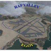
By Gordon Barnes, the RAF Valley layout (EGOV) on Anglesey, North Wales, appears as it did in 2010. It covers Hawk T1 jet training for 19 Squadron and 208 Squadron, while taxiways and building posi…
United Kingdom
Deline, Tulita, Norman Wells and Fort Good Hope airports are included, and the project is completely redesigned from scratch with custom models and visuals by Frits Beyer and Jacques Botha. It work…
 Canada