Page 22
Searches the whole library — filter by sim & category on the results page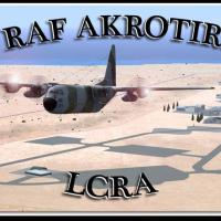
Royal Air Force Station Akrotiri on the Mediterranean island of Cyprus uses IATA AKT and ICAO LCRA identifiers and sits 10 km south-southwest of Limassol within the UK sovereign base area of Akroti…
 Cyprus
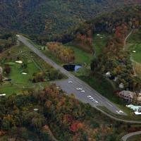
Registration 2NC0 designates Mountain Air as a private airstrip, signaling its identity to pilots and collectors. It sits at 4400 feet in elevation, tucked amid Appalachian Mountains and noted for …
 United States of America
Teterboro in New Jersey sits across the Hudson from midtown Manhattan, functioning as a general aviation reliever with no scheduled airline service or aircraft over 100,000 pounds. Version 2.0, cre…
United States of America
Eight named bases form a Bahamas-focused seaplane collection by Chris Carel, including Bahamas_West, Conch_Bay, Cutlass_Bay, Deadmans_Cay, Exuma_Intl, Marsh_Harbor, Nassau, and Treasure_Cay. The pr…
 Bahamas
The airport near Bristol, code EGGD, receives a revised layout with a new cargo terminal and expanded overflow parking, and an increased presence of fuel trucks. Created with ADE and credited to MG…
 United Kingdom
Pittsburgh's KPIT receives gate and parking updates, with all jetways visible and operable while WoAI traffic is supported. Jetways can be summoned by pressing CNTRL-J, and Rob Touchtone creates th…
United States of America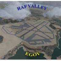
By Gordon Barnes, the RAF Valley layout (EGOV) on Anglesey, North Wales, appears as it did in 2010. It covers Hawk T1 jet training for 19 Squadron and 208 Squadron, while taxiways and building posi…
United Kingdom
Deline, Tulita, Norman Wells and Fort Good Hope airports are included, and the project is completely redesigned from scratch with custom models and visuals by Frits Beyer and Jacques Botha. It work…
 Canada
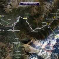
A mountain hut sits in the French Alps near Mont Blanc and offers two variants: the original structure and a second version with a helipad. Created by Manolo Dobrazil, the hut remains in an alpine …
 France
An add-on expands Namibia with 207 airfields and landmarks across diverse regions, and uses ADE X v1.5 for precise runway placement. A companion NAMIBIA_AIRPORTS_UPDATE_1.ZIP provides refinements, …
 Namibia
Two runway configuration variants for the Pittsburgh-area airport use KPIT_ADE_CW_RS.BGL to enable crosswind operations with all four runways active, or KPIT_ADE_RS.BGL to retain the default scheme…
United States of America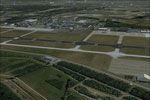
Designed for NL2000 v4 by NL2000 contributors, the Eindhoven Airport (EHEH) module emphasizes accurate taxiways, aprons, and gate positions, with refined terminal facilities. It also updates ground…
 Netherlands
Ray Smith develops a KBWI layout with two BGL variants, KBWI_ADE_RS.BGL and KBWI_ADE_CW_RS.BGL, preserving default runway use or enabling crosswind operations via Jim Vile’s method. ADE by Jon Mast…
United States of America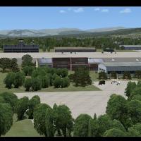
Petropavlovsk-Kamchatsky Airport in Kamchatsky, Russia, is created by Jacques Botha, relies on default library resources, and includes a layout file derived from Google Earth. The layout file is de…
 Russian Federation
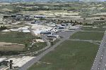
Two-airport pair includes Zweibrucken (EDRZ) and Pirmasens (EDRP); it uses stock and freeware objects and is optimized for VFR Germany. The design relies on Airport Design Editor 9_147, with freewa…
 Germany
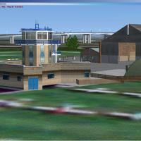
At Barton City Airport in the UK, the site marks Manchester’s first airfield, dating to 1930, and houses flying clubs, helicopter and fixed-wing operations, including Europe’s oldest control tower.…
United Kingdom
Four Carrier arrangement v5.0, by T. Marson, includes Miramar, Oceana, Pensacola U.S., and Yokosuka, Japan, with localizer, DME, arrestor cables, and an NDB on deck for headwind approaches. Updated…
 Global (World)
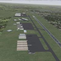
By Lee Marrow, this UK airfield project for code EGNX uses stock FSX objects and adds cargo on the ramp. Parking slots expand and ground activity increases, while compatibility with stock FSX objec…
United Kingdom
FRPX v1 spans France, highlighting monuments across more than 100 cities and remaining compatible with SP1, by Olivier Bochu. Acknowledgments extend to Guy Rosello Culliere, Rafaël Garcia Sanchez f…
France
Decimomannu LIED on Sardinia has two asphalt runways: 17R/35L at 8565 feet (2611 m) and 17L/36R at 9810 feet (2990 m), elevation 100 feet. It uses VORDME DEM 108.25, TACAN DEC 108.00, NDB 331 kHz, …
 Italy
Italy