Page 25
Searches the whole library — filter by sim & category on the results page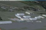
Two Pacific Northwest airports, Fridar Harbor and Lopez Island, are developed with ADE9x, replacing default Friday Harbor structures with more accurate ones and adding missing taxiways on the Lopez…
 United States of America
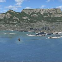
Freeware add-on expands detailed harbors and landmarks across Southern Africa, including the Darling windfarm, Bloukransbridge, Stormsriverbridge, Ruacana in Namibia, and the Bloemfontein Waterfron…
 Global (World)
By Shanard Letang, SVVA in Valencia, Venezuela serves as a hub for Aserca Airlines, Aeropostal and Avior Airlines, with domestic and international flights across the Caribbean, Colombia, Europe and…
 Venezuela (Bolivarian Republic of)
Le Touquet airport, LFAT, in France, receives an ADE v1.37 file by Er-Jin Jang that replaces the stock layout, delivering precisely placed aprons, accurate runways, and realistic autogen, with a fo…
 France
Near Sliač in central Slovakia, the LZSL_Sliac.zip add-on enhances the airfield with hardened shelters by Jiri Masnik, plus drive-through shelters and improved apron layouts around the base. RWY12 …
 Slovakia
EDTG Bremgarten AB V.1.0 centers on the former AG 51 Immelmann at Bremgarten (EDTG) in southern Germany. Designers Malte Deja and Wolfgang Schroeder build the project, and it uses the VFR Germany 3…
 Germany
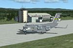
Developed by Jim Cook, this freeware add-on refines Eielson AFB near Fairbanks, Alaska, with an updated ICAO layout for PAEI and new Military_Cargo and Military_Combat parking. Two BGL files, AFX_P…
United States of America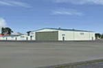
A photo-based terrain depiction relies on USGS 2005 Arizona aerial data, spans 968 square miles from Jerome to Skull Valley, including autogen, night lighting, water, while Ernest A Love Field (KPR…
United States of America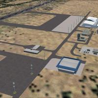
Gustavo Luna creates a freeware add-on for SBPJ in Brazil, Palmas in Tocantins, with faithful taxiway signage and static and dynamic elements. A bitmap named SBRF_patioLuz.bmp integrates into the v…
 Brazil
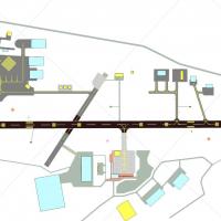
John Ball delivers improvements around Coventry’s EGBE airfield, adding custom buildings. The main runway 05/23 measures 6,600 feet with 600-foot and 700-foot displaced thresholds, while runway 17/…
 United Kingdom
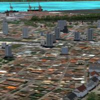
Gilson Cirino develops a landclass project that covers Paranaguá town, its port, Ilha do Mel, and rural areas along Paraná’s southern coast, with a file set including cvx_XXX.bgl, Ilhadomel.bgl, Pa…
Brazil
Two EKAT editions exist for Anholt Island: EKAT for Default & Ultimate Terrain Europa X, and EKAT for DAN-VFR Danish Photo coverage, in EKATX.ZIP, with Jens Peter Bruun-Hansen credited as the freew…
 Denmark
At Moffett Federal Airfield in California, this update replaces the historic structure and two blimp hangars at Tusstin MCAS with more accurate models, a modification by Jim Dhaenens. Files named h…
United States of America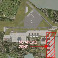
The KNIP facility in Florida enters a third rendition, adding two new hangars—one helicopter hangar on the seawall and one P-3 hangar by the VP-30 complex. The build relies on a mix of native libra…
United States of America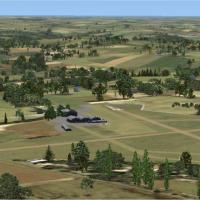
Alf Denham expands three UK airfields, Bodmin EGLA, Goodwood/Chichester EGHR, and Truro EGHY, with refined hangar outlines, improved runway environs, and more developed taxiways and ramps. The proj…
United Kingdom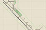
Jim Cook delivers a Davis-Monthan AFB upgrade in Tucson, Arizona, as a detailed reinterpretation that updates taxiway and apron geometry, adds designated military parking and helipads, and replaces…
United States of America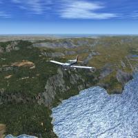
Raimondo Taburet creates a 19-meter mesh covering the Balearic archipelago, delivering considerably finer detail than SRTM data for flight simulation contexts. The work remains free to distribute a…
 Spain
Spain
By Alf Denham, Volume 18 updates several small UK airfields including Baxterley X3BX, Fowlmere EGMA, and Wolverhampton/Halfpenny Green EGBO. Based on external mapping data and airport guides, it us…
United Kingdom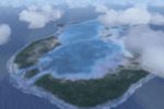
An east-side portion comprises 52 of the 78 Tuamotu islands, enabling the broader archipelago when used with Tuamotu-X_A (fpta-xa.zip). Tuamotu-X_B comprises bgl files and bmp images, plus Tuamotu-…
 French Polynesia
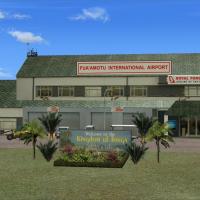
NFTF in Tonga is depicted with detailed international and domestic terminal areas, while exterior areas remain simple. By Lawrie Roache, the work credits him for object placement, with Godfrey Tier…
 Tonga
Tonga