United Kingdom

Page 3

Sort
Reset
No image available.

UK ANO Objects

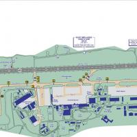
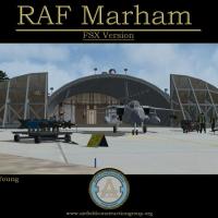
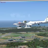
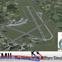
Covering 307 charted sites across England, Wales, Scotland and Northern Ireland, this Microsoft Flight Simulator X scenery add-on positions the CAA-listed En-Route Air Navigation Obstacles—radio masts, broadcast towers, chimneys, pylons and stacks—at georeferenced coordinates, supplying UK VFR pilots with faithful landmark beacons, accurate obstruction-clearance cues and sharper low-level situational awareness.

File Size
336.59 KB
Total Downloads
953
Star Rating
5/5
No image available.

UK Refineries

FSX UK Refineries scenery inserts accurately placed oil refineries and petro-chemical complexes across England and Wales, giving VFR flyers distinctive industrial silhouettes and cooling-tower smoke stacks for visual fixes. Built with Ted Andrews’ FSX-native objects via RWY12, it aligns with Horizon photoscenery and VFR Terrain mesh.

File Size
2.15 MB
Total Downloads
696
Preview screenshot

Alfs UK Airfields Update 1

Old Warden EGTH, home to the Shuttleworth Collection, gains a revised FSX layout with photoreal building models captured on-site, corrected ICAO data, hand-tuned landclass plus optional BGL packages for static aircraft, ground clutter, hedgerows and vehicles, letting UK VFR pilots optimise frame-rate against detail at the Bedfordshire grass strip.

File Size
19.78 MB
Total Downloads
695
Screenshots
5
No image available.

EGNT

This AFCAD upgrade for EGNT Newcastle Airport, North-East England, restructures gate numbering, reallocates stands, refines taxiway links, and inserts a fuel storage zone plus on-airport fire station, delivering correct parking codes and smoother AI traffic behaviour for Microsoft Flight Simulator X users curating detailed UK airport scenery.

File Size
9.09 KB
Total Downloads
662
Preview screenshot

Alf's UK Airfields Volume 11

Focused on the United Kingdom’s smaller strips, Alf’s UK Airfields Volume 11 for FSX refreshes Sheffield City (EGSY), Sutton Bank glider field (XSUT) and Welshpool (EGCW) with custom buildings, accurate runway geometry, revised AFCADs and native library objects crafted from Google Earth and Pooleys data, compatible with SP2 default terrain.

File Size
11.67 MB
Total Downloads
651
Screenshots
11
Preview screenshot

Newquay Airport

Updated with current ADEX geometry, this FSX scenery converts ex-RAF St Mawgan (EGDG) into present-day Newquay Airport EGHQ, deactivating obsolete taxiways, preserving four real-world runway exits, injecting stand-aligned passenger and GA parking, default structure footprints, and corrected menu naming for authentic Cornwall regional operations.

File Size
115.63 KB
Total Downloads
600
Screenshots
1
Preview screenshot

Northern England Power Stations

This FSX scenery package plants the cooling stacks of Drax, Ferrybridge, Eggborough and Runcorn into Northern England, supplying reliable VFR landmarks for Microsoft Flight Simulator X flyers navigating the Trent-Ouse valley and Mersey corridor. Discrete steam FX are included, buildings excluded, ensuring minimal performance drag while enriching UK airspace realism.

File Size
46.05 KB
Total Downloads
559
Preview screenshot

EGNH Blackpool Squiresgate

Detailing EGNH Blackpool Squiresgate on the Lancashire coast, this FSX scenery package integrates with Horizon GenX photo-mesh, delivering terrain flattens, precise three-runway data, apron floodlights, NAV2-activated hangar doors and bespoke clutter objects; included library calls render Vickers factory bays, Pontins holiday units and adjacent warehouse estates for an authentic mixed civil-military airfield environment.

File Size
1.12 MB
Total Downloads
555
No image available.

Liverpool Scenery Patch

Designed for the UK regional index, this FSX addon patch refines Gareth Davies’ original Liverpool cityscape and EGGP approaches by correcting floating roof models, realigning polygon footprints, and tidying minor mesh anomalies, delivering cleaner autogen placement and smoother VFR transitions across Merseyside’s urban coastline.

File Size
86.31 KB
Total Downloads
543
Preview screenshot

Alf's UK Airfields Volume 15

This freeware scenery pack, Alf’s UK Airfields Vol 15, refreshes Eggesford X2EG, Eshott EG18 and Swansea EGFH for Microsoft Flight Simulator X SP2, inserting accurate runway geometry, revised landclass polygons and stock-library structures generated with ADE and the FSX SDK, giving GA pilots cleaner taxi flows and more lifelike circuit references.

File Size
8.57 MB
Total Downloads
538
Star Rating
5/5
Screenshots
11
Preview screenshot

Morecambe Bay Gas Rigs

FSX Morecambe Bay Gas Rigs adds the cluster of offshore production platforms west of Blackpool, recreating flares, obstruction beacons and heli-deck markings for realistic VFR navigation over the Irish Sea; accurate coordinates, custom night lighting and low-impact performance suit coastal approaches into Northwest England airports.

File Size
94.58 KB
Total Downloads
419
Star Rating
2/5
Preview screenshot

Benbecula Airport

Benbecula Airport (EGPL/BEB) scenery addon for Microsoft Flight Simulator X refreshes the Outer Hebrides hub with a revised AFCAD, accurate runway markings, updated PAPIs, custom terminal geometry and coastline adjustment, mirroring Highlands and Islands Airports data for GA shuttles, Loganair Saab 340 schedules, SAR sorties and IFR training.

File Size
588.45 KB
Total Downloads
391
Star Rating
2/5
Screenshots
1
Preview screenshot

RAF Fylingdales

FSX freeware add-on places the tri-faceted RAF Fylingdales radar station on Lockton High Moor, North Yorkshire, giving UK VFR fliers an accurate ballistic-missile early-warning landmark that aligns with Ordnance Survey data and Horizon Gen-X photo terrain; authored by Geoff Smith, compiled for default and custom scenery libraries.

File Size
211.5 KB
Total Downloads
378
No image available.

Telecom Tower

Telecommunications and utility structures for Flight Simulator X refresh the West Yorkshire–Lancashire airspace: BT Tower southeast of EGNM, Menwith Hill radomes, Ilkley Moor and Cop Hill transmitters, Huddersfield chimneys and scattered microwave sites yield reliable VFR waypoints, realistic obstacle lighting and improved radio-navigation context throughout the Pennine sector of northern England.

File Size
2.59 MB
Total Downloads
372
Preview screenshot

EGKR Redhill

Serving the United Kingdom index, this FSX add-on refreshes Redhill Aerodrome EGKR with five turf runways, several helipads, corrected landclass polygons and refined airfield objects, presenting an authentic VFR landmark in Surrey just north of Gatwick while maintaining negligible FPS impact.

File Size
404.96 KB
Total Downloads
337
Star Rating
1/5
Screenshots
3
Preview screenshot

Sywell Aerodrome

Covering Northamptonshire’s Sywell Aerodrome (EGBK/ORM) for Microsoft Flight Simulator X, this UK scenery pack reproduces the asphalt 03/21 runway, intersecting grass strips, Art Deco terminal hotel, flying club ramp and GA hangars, adding ADE-optimised AFCAD, realistic taxiway lighting and precise ground polys so VFR circuit work and local training sorties tie in with current AIP data.

File Size
661.79 KB
Total Downloads
303
Screenshots
2
Preview screenshot

ADE File For EGLL

This ADE upgrade for London Heathrow Airport EGLL refreshes the stock Microsoft Flight Simulator X layout by inserting Terminal 5 footprints, reallocating gates for British Airways at T1 and T5, and correcting Terminal 4 usage, yielding truer-to-life stand positions and extra parking for smoother virtual ground handling within UK airspace.

File Size
28.62 KB
Total Downloads
272
Preview screenshot

EGRA Cardington NAS Update

Microsoft Flight Simulator X scenery EGRA Cardington NAS Update revises the historic Bedfordshire airship base with corrected R101 day- and night-textures, overhauled AFCAD layout, a new taxiway spur leading into Hangar 2 for gas replenishment, improved roof hazard beacons, interior luminaires and cleaned-up BGL packages—valuable for UK VFR or lighter-than-air operations.

File Size
300.2 KB
Total Downloads
262
Star Rating
4/5
Screenshots
2
Preview screenshot

Wallington House, Northumbria

Wallington House adds the 17th-century National Trust estate near Alnwick to FSX and legacy FS2004, aligning with Horizon VFR Generation X Vol 3 photoreal coverage (2.4 m textures, 5 m mesh) at N55°09.12′ W1°57.38′, providing a reliable VFR landmark for light-aircraft training and scenic GA hops across rural Northumberland.

File Size
1.23 MB
Total Downloads
246
Screenshots
1
Preview screenshot

Chesterfield Parish Curch

Chesterfield Parish Church scenery brings the crooked 228-foot spire of Derbyshire’s landmark into Microsoft Flight Simulator X and FS2004, offering a reliable VFR reference near Sheffield City Airport at N53°14.16 W1°25.49; the add-on integrates custom textures, night lighting and accurate scale to aid UK Midlands navigation.

File Size
1.18 MB
Total Downloads
232
Screenshots
1

16 pages with 309 downloads.

previous12345678910111213141516next