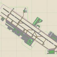
United States of America

Page 28

Sort
Reset
Preview screenshot

Landclass For Santa Barbara

FSX Landclass for Santa Barbara replaces default Flight Simulator X terrain with refined land-class data and autogen, positioning UCSB, Goleta, Montecito and KSBA structures per sectional charts; hundreds of coastal hotels, campus buildings and city blocks assist VFR pilots, compatible with CCCFSX or stock scenery.

File Size
5.22 MB
Total Downloads
373
Screenshots
7
Preview screenshot

Hana Airport

For FSX pilots charting the United States Hawaii region, this freeware rework of Hana Airport PHHN refines runway/taxiway footprints to FAA data, injects geo-referenced default objects, adjusts CVX terrain and coastline, and preserves AI traffic paths; compiled in Airport Design Editor for seamless general aviation and island shuttle operations.

File Size
327.69 KB
Total Downloads
373
Star Rating
1/5
Screenshots
1
Preview screenshot

Tweed New Haven

A deliberate FSX refresh for Tweed New Haven Regional (KHVN), Connecticut, introduces a custom .bgl AFCAD with true-to-chart gate layout (1-3, 2a/5, Part 135 stand), revised terminal geometry, functional jetway, re-profiled control tower, added fire station, apron detail, and an extended Taxiway B reflecting current FAA data.

File Size
9.22 MB
Total Downloads
372
Star Rating
4/5
Screenshots
20
No image available.

3 GPS Oil Platforms

Covering the Gulf of Mexico off Louisiana and Texas, this FSX update positions three GPS-coded offshore rigs—KLFO Lafayette, KGLO Galveston and KNGO Corpus Christi—complete with helipads, nearby carrier groups, Very-Dense ship traffic, custom VOR/NDB stations and tidy ADE layouts, useful for rotorcraft shuttles, radio-navigation practice and maritime approach training.

File Size
4.97 MB
Total Downloads
371
Preview screenshot

Rochester New York

Covering Rochester, New York’s Lake Ontario shoreline, downtown skyline and KROC approach corridors, this FSX add-on inserts custom autogen, updated landclass and accurately placed POIs such as the Eastman Kodak complex and Genesee River bridges, helping regional IFR/VFR training flights align with real-world sectional charts and current FAA procedures.

File Size
4.18 MB
Total Downloads
371
Star Rating
1/5
Preview screenshot

KSNA

KSNA AFCAD v1.1 refines John Wayne Airport, Orange County for FSX, incorporating 2010 terminal allocations, corrected taxiway geometry, TUSTI LDA transition on 19R, refreshed SID/STAR nav-data, cargo stands for UPS and FedEx, plus accurate AI parking codes and size limits. Runway 1R/19L arrivals are disabled to sidestep the heavy-aircraft bug, with optional apron lighting support.

File Size
1.17 MB
Total Downloads
369
Screenshots
1
Preview screenshot

Scenery--Lawton Airport

Flight Simulator X users gain a precise visual refresh of Lawton–Fort Sill Regional Airport, ICAO KLAW, Oklahoma, through this freeware scenery add-on; Rwy12 and EZ-Scenery libraries introduce tailored aprons, terminal assets, landclass refinements and updated lighting, supporting regional jet, GA and Army trainer movements across the southern plains.

File Size
579.4 KB
Total Downloads
368
Star Rating
1/5
Screenshots
4
No image available.

Sheppard AFB/Wichita Falls

KSPS Sheppard AFB / Wichita Falls Municipal Airport for FSX updates taxiway layouts, ramp dimensions, parking codes, crosswind runway activation and tower placement while adding stock Acceleration objects, static military aircraft and support vehicles, supplying a chart-accurate North Texas dual-use field for regional or training sorties.

File Size
177.79 KB
Total Downloads
365
Preview screenshot

Wrangell Airport

Wrangell Airport PAWG Alaska for Microsoft Flight Simulator X refreshes the default airfield with revised aprons, realistic terminal buildings, ramp vehicles, people libraries and static aircraft, all compiled in ADE 9x. Updated navigation data covers the offset ILS on Runway 10, while accurate terrain polygons and landclass capture the narrow fjord, mountain and lake environment for bush pilots.

File Size
407.05 KB
Total Downloads
361
Star Rating
2/5
Screenshots
1
Preview screenshot

Copalis State Airport Scenery (FAA LID: S16)

Copalis State Airport S16 for FSX renders the United States’ only ocean-beach airfield, providing a 4,500-ft tidal sand runway on Washington’s Pacific shore from the Copalis River to basalt rocks northward; tailored for Orbx PNW, it blends photoreal beach textures, precise coastal landclass and supports bush flying, STOL and general aviation ops.

File Size
17.6 MB
Total Downloads
359
Star Rating
5/5
Screenshots
33
Preview screenshot

Gainesville Airport

KGNV Gainesville Regional for FSX refreshes Florida flying with custom terminal geometry, corrected AFCAD data, photoreal textures, revised landclass, and a local object library that integrates with Ultimate Terrain X-USA; compiled via ADE, this freeware gives precise runway, taxiway, and gate layouts for regional jet and GA operations.

File Size
1 MB
Total Downloads
359
Screenshots
45
Preview screenshot

KFAT

KFAT Fresno Yosemite International AFCAD for Microsoft Flight Simulator X updates the stock airport layout with accurately positioned cargo bays, extra general-aviation tie-downs, defined helicopter pads, and dedicated military stands tuned to MAIW traffic, improving AI pathing and parking logic at this Central California hub.

File Size
79.5 KB
Total Downloads
358
Screenshots
1
Preview screenshot

Mobile Downtown Airport

Mobile Downtown Airport KBFM for Microsoft Flight Simulator X modernises this United States Gulf Coast hub with revised AFCAD geometry, photoreal ground polys, balanced night lighting, custom terminal models from Woodward’s library, accurate apron markings, GA ramp parking and calibrated PAPI/ILS data, matching current FAA charts without taxing frame rates under DX10.

File Size
339.96 KB
Total Downloads
356
Screenshots
2
Preview screenshot

KFLL by J. D. Starseed

This FSX AFCAD update for Fort Lauderdale–Hollywood International Airport (KFLL) revises runway designations to current FAA magnetic headings, improving ILS capture, SID/STAR conformity, ATC phraseology and VATSIM or other multiplayer network consistency—handy for Florida hub operations within Microsoft Flight Simulator X and allied flight-planning tools.

File Size
134.72 KB
Total Downloads
355
Screenshots
1
Preview screenshot

Sacramento Executive Airport

KSAC Sacramento Executive Airport v2 refines the default FSX airfield with corrected taxiway geometry, accurate GA ramp spots, and removal of the stray beacon at the south fuel farm; compiled via Airport Design Editor and using default library assets for a lightweight, frame-friendly regional upgrade.

File Size
411.49 KB
Total Downloads
353
Screenshots
1
Preview screenshot

Essex County Airport

Serving the busy New York–New Jersey general-aviation corridor, Essex County Airport (KCDW/CDW) scenery for Microsoft Flight Simulator X deploys high-resolution orthoimagery, custom 3-D terminals, updated AFCAD data, dynamic night environment and precise taxiway signage across runways 4/22 and 10/28, blending seamlessly with wider USA northeast terrain for consistent VFR and IFR routing.

File Size
3.39 MB
Total Downloads
352
Star Rating
5/5
Screenshots
3
Preview screenshot

Wilson Lake And River Alaska

Realigns Wilson Lake, Big Goat Lake and the adjoining Wilson River to proper geo-coordinates in Flight Simulator X, widens the channel and applies legacy waterclass, giving floatplane pilots a practical water runway for bush VFR sorties, scenery tweaking and custom mission design across rugged Alaskan terrain.

File Size
919.86 KB
Total Downloads
352
Star Rating
5/5
Screenshots
2
No image available.

Updated Carrier Group Oceana

FSX “Updated Carrier Group Oceana v2” plants a double-carrier task force 12 nm northeast of NAS Oceana, Virginia, complete with functional arrestor wires, deck-parked SH-60s, dual LOC/DME beacons (108.95 IABA Cat II, 109.30 IABB Cat III) and a 401 kHz NDB, giving study-level pilots a tidy naval operations playground without spawn points on the decks.

File Size
12.92 MB
Total Downloads
352
Preview screenshot

Laurence G. Hanscom Field

KBED – Laurence G. Hanscom Field for Microsoft Flight Simulator X refines the Bedford, Massachusetts general-aviation hub with corrected aprons, realistic taxiway geometry, custom hangars, light poles, parking lot traffic and static AI aircraft; BGL scenery crafted via Flight1 AFX and Instant Scenery using AirNav and Google Earth data for accurate VFR and IFR navigation.

File Size
14.58 KB
Total Downloads
351
Star Rating
3/5
No image available.

Fly Delta Jets Hangar

Delta’s Fly Delta Jets maintenance hangar now populates the KATL ramp in FSX, adding custom night lighting, reflective materials and accurate LOD scaling to Hartsfield-Jackson Atlanta International. This lightweight United States scenery add-on enriches southeastern U.S. airport layouts for flight-simulation pilots operating dense AI traffic or VATSIM routes.

File Size
1.67 MB
Total Downloads
351