Page 31
Searches the whole library — filter by sim & category on the results page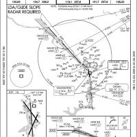
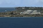
Ronald Reagan Washington National (KDCA) AFCAD upgrade for FSX revises the stock District-of-Columbia scenery with three active runways, Rosslyn LDA-R 19, complete RNAV/RNP approach set, calibrated…
FSX Wheeler Army Airfield (PHHI) scenery brings Hawaii’s historic Oahu rotary-wing hub into Microsoft Flight Simulator X with additional military hangars, static UH-60 pads, support vehicles, and r…
FSX rendition of Harrisburg International Airport KMDT, Pennsylvania, refreshes the stock field with revised aprons, accurate taxiway geometry, airline-coded gates, dedicated GA, cargo and National…

FSX pilots navigating U.S. domestic sectors into Arkansas will find this ADE-engineered AFCAD upgrade for Little Rock National Airport KLIT slots neatly into default scenery; the file activates the…
Covering Grand Forks International Airport KGFK in North Dakota, this FSX scenery update reinstates the new 17R/35L pavement, clarifies taxiway nomenclature, removes duplicate signs, refreshes ILS …

Covering the arid test corridors of Nevada and California, this FSX military set updates Pahute Mesa L23, Fort Irwin BYS, Terabone bone-yard 0CL8 and Tonopah Missile Test Range TNX, introducing cor…
This airfield scenery package for Marine Corps Air Station New River (KNCA) near Jacksonville, North Carolina overhauls the default FSX base with additional military-cargo and combat parking, adjus…

FSX pilots seeking accurate Hawaiian vector data will find this Lanai and Kahoolawe landclass addon useful; revised urban polygons for Lanai City, added roads, trails and the rarely charted Kahoola…
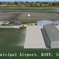
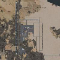
Low-traffic GA flying remains practical at KOXV Jim Bellamy Field, Knoxville, Iowa, in this FSX add-on, featuring the 4,000 × 75 ft grooved concrete strip, full parallel taxiway, 928-ft field eleva…
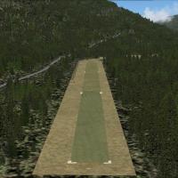
Fly with FSX into Idaho’s Johnson Creek (3U2) backcountry strip recreated in this scenery, featuring photoreal ground polygons for the turf runway, hand-placed trees, campsite objects, log cabin, s…

Bush pilots will spot this FSX scenery add-on updating PATA / Ralph M. Calhoun Memorial Airport with its 4,400-ft gravel 7/25 strip, stock NDB 212 BCC and VOR 116.6 TAL, plus a riverside Inuit vill…
Set along Seattle Bay, Sea Harbor WA installs two fictional water aerodromes—1RL and 7WA5—featuring floatplane ramps, marina-linked taxiways, custom ILS approaches and dock parking for amphibians. …
Covering Malibu, California, this FSX Acceleration add-on positions Aeroworks Flight Center 2 atop a 1,400-ft ridge with a 4,000-ft asphalt strip, multiple helipads and detailed hangars, plus the b…
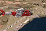
CGAS Elizabeth City (KECG) scenery enhancement for Microsoft Flight Simulator X portrays the U.S. Coast Guard air station on North Carolina’s Pasquotank River with revised aprons, realigned taxiway…
FSX Killeen / Fort Hood Airport (KGRK) scenery mod refines Robert Gray Army Airfield for Microsoft Flight Simulator X with a bespoke terminal model, extended civilian apron layouts, working jetways…
Enhances John F. Kennedy International Airport (KJFK) for FSX by adding accurate lead-in lighting to the Parkway Visual 13L/13R, often called the Canarsie approach, giving flight sim pilots authent…
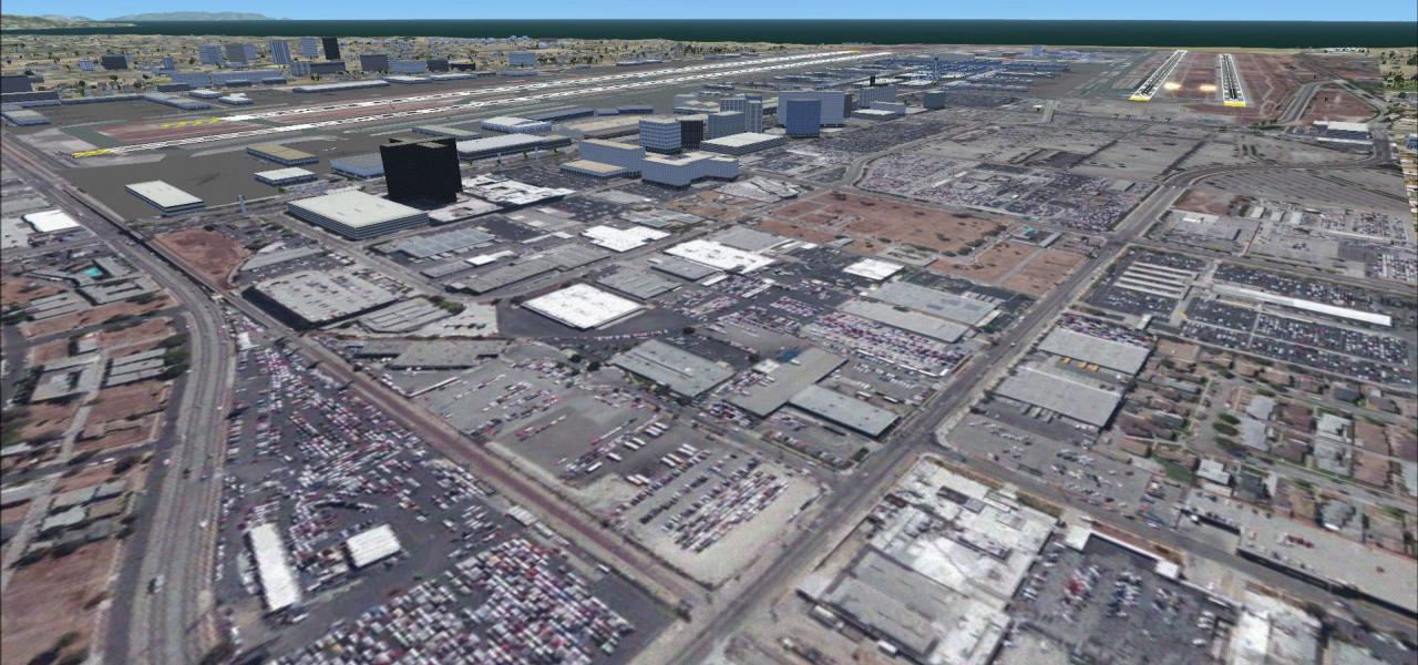
North Las Vegas ILS pack inserts a precise CAT I instrument landing system for runway 12L at KVGT, bringing correct localizer 110.70 MHz with DME 044X, 3.2-degree glidepath and 14°E variation, givi…

Refresh FSX coverage over Texas with this Abilene Regional Airport (KABI) overhaul, providing revised taxiway geometry, redrawn aprons, dedicated American Eagle gate assignments, new terminal and h…
KSLC Salt Lake City International scenery for FSX refines Utah’s primary hub with correctly coded gates, airline-specific parking, realistic terminal spacing and signage mapped from current charts,…
FSX scenery upgrade for MCAS Beaufort (KNBC) in South Carolina refines the stock Marine Corps air station with additional Military_Cargo and Military_Combat stands, re-profiled taxiways and aprons,…