United States of America

Page 34

Sort
Reset
Preview screenshot

Carbon County Regional/Buck Davis Field

Refines Carbon County Regional-Buck Davis Field KPUC in Utah for FSX default scenery, delivering a re-plotted runway profile, corrected taxiway geometry, accurate apron stands, GA tie-downs and vehicle parking based on current FAA charts and Google aerial data, compiled through Airport Design Editor 9X for seamless AFCAD integration.

File Size
3.22 MB
Total Downloads
258
Preview screenshot

Cape Girardeau Regional Airport

Cape Girardeau Regional Airport KCGI scenery enhancement for Flight Simulator X refreshes southeast Missouri’s general-aviation node with accurately georeferenced runways 10/28 and 02/20, revised AFCAD, calibrated ILS data, realistic control tower, EZ-Scenery hangars, custom ramp lamps, static Beech 1900D and C182R, harmonising with default mesh, autogen and regional photoreal layers.

File Size
5.85 MB
Total Downloads
258
Screenshots
2
Preview screenshot

California Central Coast (Revision 4)

Covering Paso Robles to Vandenberg, this freeware Microsoft Flight Simulator X add-on, California Central Coast Revision 4, updates KPRB, KSMX, KVBG, KSBA, KSBP and L52 with the Estrella Warbird Museum, animated ASR-9 surveillance radars, refined landclass, night lighting and revised AFD files, supplying VFR pilots and IFR planners sharper runway data, improved landmarks and a balanced coastal terrain profile.

File Size
1.02 MB
Total Downloads
258
Star Rating
5/5
Screenshots
3
Preview screenshot

Groton New London Airport

FSX rendition of Groton-New London Airport (KGON) refreshes the Connecticut coastal airfield with expanded GA stands, dual mobile fuel tenders, Rhode Island Air National Guard ramp, static rotary- and fixed-wing assets, corrected AFCAD taxiway geometry, signage tweaks, added hangars, fire station, plus proper helipad marking, yielding more accurate circuit training and IFR practice.

File Size
9.7 KB
Total Downloads
258
Preview screenshot

Lebanon Municipal Airport

Flight Simulator X pilots updating their U.S. Northeast hangar can slot this Lebanon Municipal Airport (KLEB) AFCAD into New Hampshire’s Upper Connecticut River Valley, adding corrected taxiway geometry, re-sited control tower, GA and Colgan gates, static vehicles, lighted car parks and stock-library buildings aligned to current FAA charts and satellite imagery.

File Size
9.5 KB
Total Downloads
258
Star Rating
2/5
Preview screenshot

Avon Park Executive Airport

FSX rendition of Avon Park Executive Airport (KAVO) positions a detailed central-Florida GA field within 80 mi of Tampa, Orlando and other hubs, featuring a scratch-built terminal modeled in SketchUp with photo-sourced windows, service hangars for maintenance traffic, and scenery cues linked to the nearby Sebring 12-Hour race and Lakeland Linder airshows.

File Size
4.78 MB
Total Downloads
257
Preview screenshot

Simmons Army Air Field

Simmons Army Air Field KFBG for FSX offers an overhauled AFCAD aligning aprons, taxiways and helipads to current AirNav charts, introduces military-combat parking, refined vehicle access roads, stock building swaps, light poles, static Humvee and support assets, and remains MAIW-friendly while running entirely on default object libraries.

File Size
15.74 KB
Total Downloads
257
Preview screenshot

Wilkes-Barre/Scranton International

KAVP Wilkes-Barre/Scranton International for FSX revamps the default Pennsylvania hub with re-drawn aprons, accurate taxiway geometry, an updated terminal fitted with active jetways, relocated ATC tower, plus detailed parking garage, hangars and ground vehicles, all built from default libraries for seamless compatibility with Ultimate Terrain, FSG landclass or stock scenery.

File Size
8.83 KB
Total Downloads
256
Star Rating
3/5
Preview screenshot

Pease AFB

FSX Pease AFB Scenery reverts KPSM to its Cold-War Air Force configuration, restoring original ramp geometry, military hardstands, transient alert spots and taxiway links for accurate AI traffic flow; ideal for sim pilots seeking period-correct New Hampshire operations in Microsoft Flight Simulator X or Prepar3D.

File Size
1.14 MB
Total Downloads
256
Preview screenshot

Northeast Philadelphia Airport

Adding accurate ramp floodlighting to KPNE Northeast Philadelphia Airport, this Flight Simulator X scenery add-on ports Amenab Slade’s 2004 package, integrating ESDG quad, dual, single and street luminaires through the Rwy12 library, sharpening apron visibility for GA night circuits and corporate jet turnarounds at the USA East Coast reliever field.

File Size
242.47 KB
Total Downloads
255
Star Rating
4/5
Screenshots
5
Preview screenshot

Middletown CT

Adding Middletown, Connecticut to an FSX library injects New England’s Connecticut River corridor with photoreal ground textures, precise shoreline vectors, hand-placed autogen, and custom objects aligned to Ultimate Terrain USA, allowing VFR pilots departing Hartford or Chester to recognize downtown blocks, campus spires, and the surrounding valley topography with correct geo-referencing.

File Size
19.84 MB
Total Downloads
253
Star Rating
1/5
Preview screenshot

Barbers Point

Spanning Barbers Point Harbor to the Electric Beach power station on Oahu’s leeward coast, this FSX autogen layer for MegaSceneryX Honolulu populates PHJR with static US Navy airframes, helicopters, seabirds and detailed shoreline assets. Performance-aware BGL grouping lets pilots tailor object density while retaining accurate Hawaiian coastal landmarks for VFR hops.

File Size
1.69 MB
Total Downloads
253
Preview screenshot

Ghost Airports Collection - Pennsylvania

Ghost Airports Collection – Pennsylvania for FSX revives 46 long-closed Keystone State airfields—among them the freshly modeled Clarion Rhea strip—with new fuel pads, corrected road vectors, and revised AFCAD data, giving VFR flyers an authentic reference when tracing 1940 sectional-chart runways now replaced by malls, factories, or housing tracts.

File Size
18.86 MB
Total Downloads
252
Screenshots
1
Preview screenshot

Craig Municipal Airport

Covering Jacksonville’s Craig Municipal Airport (KCRG), this FSX scenery refines the airfield layout, recreates the Craig Air Center FBO and service apron, aligns runways, taxiways and approach lighting to current FAA charts, and uses an included object library for dense static assets optimised for UTX-USA, Very Dense detail levels and ADE editing.

File Size
456.32 KB
Total Downloads
252
Screenshots
44
Preview screenshot

V2.2 
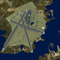
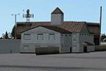
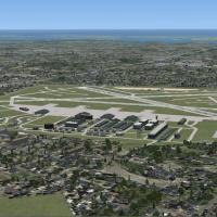
McAllen Miller Int'l Airport
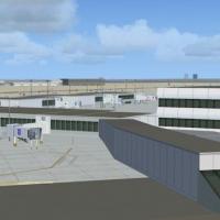
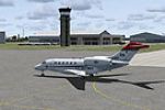
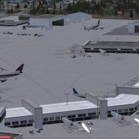
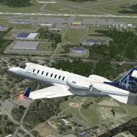
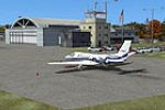
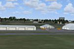
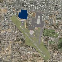
Version 2.2 refreshes McAllen Miller International Airport (KMFE) in south Texas for FSX and Acceleration, aligning taxiways, parking stands and aprons to current FAA charts with ADE-generated BGLs and HD satellite orthos; regional POIs—Convention Center, Border Patrol complex, Dodge Arena, retail mall, golf courses and nearby hotels—aid VFR navigation across the Rio Grande Valley and broaden United States airport scenery collections.

File Size
7.39 MB
Total Downloads
252
Screenshots
33
Preview screenshot

Kistler Ranch

FSX rendition of Kistler Ranch (08CL) places a 2,000-ft dirt strip and summer-camp outbuildings west of Jamestown, California, at 981 ft MSL, with custom ground polys, regional autogen and accurate UNICOM 122.9 MHz—ideal for short-field, back-country bush flying in the Sierra Nevada foothills.

File Size
25.58 MB
Total Downloads
250
Star Rating
1/5
Screenshots
10
Preview screenshot

Greater Binghamton Regional

FSX rendition of Greater Binghamton Regional Airport (KBGM, New York) refreshes the default field with revised aprons, realigned taxiways, updated service roads, a scratch-built terminal sporting animated jetways, and a scaled control tower; additional fire station, static GA and regional jets, plus realistic airline gate coding round out this stock-library build tuned via AirNav charts and Google Earth.

File Size
19.74 KB
Total Downloads
250
Preview screenshot

Sky Harbor Airport

Sky Harbor Airport KDYT scenery for Microsoft Flight Simulator X revises this Duluth, Minnesota shoreline strip with updated aprons, realistic taxiway routing, replacement stock structures, enlarged general-aviation and floatplane stands, added static vehicles, light masts and fencing, delivering dual land/water runway operations that track current AirNav and satellite data.

File Size
5.22 KB
Total Downloads
250
Preview screenshot

Aspen-Pitkin County/Sardy Field

This Microsoft Flight Simulator X scenery for Aspen–Pitkin County/Sardy Field KASE applies Google-Earth-matched geometry across runways 15/33, taxiways, and GA parking, injects stock library assets for local detail, and retains ADE-compiled, high-elevation performance suited to challenging Rocky Mountain approach profiles in Colorado freeware form.

File Size
287.84 KB
Total Downloads
247
Screenshots
1
Preview screenshot

Bremerton National Airport

FSX users focusing on U.S. Pacific Northwest hops will find this Bremerton National Airport (KPWT) scenery handy, adding custom GMAX structures, detailed hangars, updated AFCAD parking, accurate taxiway signage, night lighting and photoreal apron textures—ideal for regional GA, med-evac and light cargo circuit practice around Puget Sound.

File Size
3.06 MB
Total Downloads
247
Screenshots
27