United States of America

Page 37

Sort
Reset
Preview screenshot

Wheeler-Sack Army Air Field

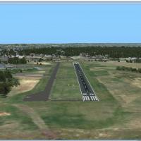
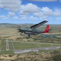
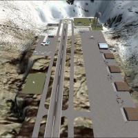
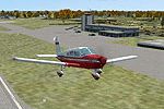
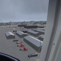
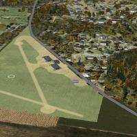
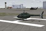
Covering Upstate New York, this Microsoft Flight Simulator X scenery refreshes Wheeler-Sack Army Airfield (KGTB) at Fort Drum with accurate aprons, re-drawn taxiways, added MIL_COMBAT and MIL_CARGO stands, replacement hangars, relocated tower, static rotary-wing assets and support vehicles, creating a current 10th Mountain Division hub suited to GA, helicopter or fast-jet circuit work.

File Size
13.62 KB
Total Downloads
232
Preview screenshot

New Mexico

High-altitude New Mexico scenery addon for FSX introduces a compact, mountain-side city with interconnected taxiway grid reaching every structure, dual asphalt runways, illuminated terminal and control tower photoreal textures, accurate day-night lighting transitions, and bundled custom AI traffic—useful for both VFR pattern work and IFR training in Microsoft Flight Simulator X.

File Size
7.63 MB
Total Downloads
232
Screenshots
1
Preview screenshot

Wings Field Airport

Covering suburban Philadelphia’s Wings Field (KLOM / N67), this FSX add-on supplies photoreal orthoimagery, season-adjusted winter textures, accurately aligned autogen, real-world taxiway geometry sourced via ADE, plus custom Gmax buildings and static GA traffic—handy for VFR circuit training, cross-country flight planning, or light IFR practice in Pennsylvania airspace.

File Size
11.63 MB
Total Downloads
230
Screenshots
4
No image available.

Northern Maine Regional

Covering KPQI—Northern Maine Regional Airport at Presque Isle—this FSX scenery add-on refines terminal facades, ramps, taxiway edge lighting, and surrounding VFR landmarks using optimized autogen and custom objects, yielding sharper apron textures, accurate gate positions, seasonal ground polys, and balanced night environment for regional GA and cargo ops.

File Size
2.94 KB
Total Downloads
230
Preview screenshot

Bemidji Regional Airport

KBJI Bemidji Regional Airport for FSX revamps the stock field with an ADE9X AFCAD aligned to current FAA data and satellite imagery, extended runways, corrected taxiway geometry, a Delta Connection gate, GA/FBO parking, Jim Dhaenens LED lighting, hangars, fuel truck and woodland parking-lot detail for realistic northern Minnesota operations.

File Size
13.44 MB
Total Downloads
229
Preview screenshot

Orlando International Airport

Updated AFCAD for Orlando International Airport (KMCO) aligns terminal stands, airline parking codes and heavy-jet clearances for FSX sim pilots seeking traffic flow closer to real-world operations. This freeware scenery by Dusty Bizub reshapes ramp geometry, revised gate numbering and wide-body spacing, enhancing approach, taxi and turnaround accuracy across central Florida’s primary hub.

File Size
30.13 KB
Total Downloads
227
No image available.

Cobb County McCollum

Cobb County McCollum Airport (KRYY) scenery for FSX delivers an updated AFCAD, high-resolution ground textures and photoreal surroundings, combining a lengthened runway, repositioned taxiways, five corporate jet hangars, road traffic, parking aprons and the on-field Elevation restaurant, offering general aviation flyers a chart-accurate slice of suburban Atlanta, Georgia airspace.

File Size
13.25 KB
Total Downloads
227
Preview screenshot

Napa County Airport

Napa County Airport (KAPC) for FSX refreshes California wine country’s gateway with satellite-aligned runway thresholds, corrected taxiway geometry, accurate tie-down spots and revised AFCAD BGLs compiled in Airport Design Editor, combining default library objects for low-overhead performance; GA pilots gain precise approaches for VFR hops around the Bay Area.

File Size
297.84 KB
Total Downloads
227
Screenshots
1
Preview screenshot

Elliott Field

Anchorage’s Elliott Field (01EF) drops a compact asphalt strip and a pumped-in water runway onto a mountain bench north of town, giving FSX bush pilots a short-field testing ground within a quick hop of Elmendorf AFB; custom ADE layout, animated hangars, backcountry terrain detail, campgrounds and hotel objects round out the small-operator vibe.

File Size
3.8 MB
Total Downloads
226
Screenshots
5
Preview screenshot

Jackson County Airport

Covering Jackson County–Reynolds Field (KJXN) in Michigan, this FSX-only enhancement adds a custom terminal with illuminated welcome sign, a purpose-built tower, refined taxiway geometry, updated signage and a fenced car park, while static GA aircraft and a legacy gate suited to a Convair 580 preserve the airport’s mixed-era character.

File Size
2.9 MB
Total Downloads
223
Screenshots
5
No image available.

Hartford

Hartford Scenery for FSX injects a focused Connecticut cityscape, supplying custom downtown assets, riverfront insurance towers and aligned roads that mesh with Ultimate Terrain USA landclass. VFR pilots will notice accurate object density for low-level passes into KBDL and nearby GA strips, adding authentic New England urban context to Microsoft Flight Simulator X flights.

File Size
2.15 KB
Total Downloads
223
Preview screenshot

Hideaway Ranger Creek

Hideaway Ranger Creek 21W scenery for Microsoft Flight Simulator X updates this Washington State back-country strip by removing invisible vegetation at the runway 15 threshold, adding subtle EZ-Scenery object detail and refined ground polys, creating a tighter short-field challenge suited to bush pilots, GA flyers and simulated VFR/IFR practice.

File Size
6.22 KB
Total Downloads
222
Star Rating
1/5
Preview screenshot

Ghost Airports - Youngstown Exec

Youngstown Executive Airport, a mid-century GA field southwest of Youngstown, Ohio, returns to Microsoft Flight Simulator X with this “ghost airport” scenery, restoring the decommissioned 3 799-ft asphalt strip (runways 11/29), original taxiway layout, torn hangars and Midwest foliage while reflecting historic magnetic headings and vintage freight-hauling ambience. Suitable for nostalgic freight runs and pattern work over the Rust Belt.

File Size
387.68 KB
Total Downloads
221
Screenshots
1
Preview screenshot

Phoenix Sky Harbor International Airport

Phoenix Sky Harbor International Airport (KPHX) scenery for Microsoft Flight Simulator X SP2 refines gate logic, dynamic CTRL+J jetways, and correctly sized cargo aprons, recreating current airline allocations at the busy Southwest Airlines hub; ADE-crafted stands integrate with WOAI or similar AI traffic, promoting smooth taxi flow across the Arizona desert airfield.

File Size
150.87 KB
Total Downloads
221
No image available.

Buffalo Niagara International

FSX pilots covering the Northeast USA will find this v3 AFCAD for Buffalo Niagara International Airport (KBUF) refreshes the layout with updated gate allocations, JetBlue overflow stands, wider aprons, and an extended 5/23 runway, eliminating prior duplicate objects and fence issues while mirroring present-day airfield geometry.

File Size
10.8 KB
Total Downloads
221
Preview screenshot

Gary Gale Seaplane Base Florida

Gary Gale Seaplane Base (0FL8) in Jacksonville, Florida gains an FSX hydrodrome upgrade that adds float docks, medium and small marinas, static floatplanes, and a 339 kHz NDB, all georeferenced with ADE to match satellite imagery and the Jacksonville sectional, supporting accurate VFR hops across north-east Florida.

File Size
4 MB
Total Downloads
218
Preview screenshot

Arlington Municipal Airport

Virtual pilots exploring the United States in Microsoft Flight Simulator X can slot in this Arlington Municipal Airport (KGKY) scenery, delivering a reprofiled taxiway layout, relocated GA stands, a redrawn road network, functional Fire Station 12, fresh FBO and hangar models, autogen vegetation, light-poled car parks and stock-library static aircraft for realistic regional traffic.

File Size
9.53 KB
Total Downloads
218
Preview screenshot

Update 6 for Ghost Airports - PA

Ghost Airport – Pennsylvania Update 6 introduces Rodgers Field plus small AFCAD tweaks across forty-six other vanished Keystone State strips, giving Microsoft Flight Simulator X pilots restored runway geometry, corrected navaids, and plausible traffic patterns for Pittsburgh, Erie, Scranton and rural GA points—handy reference for VFR charts, historical bush flying, or retro route planning.

File Size
19.53 MB
Total Downloads
216
Screenshots
1
No image available.

KBRD

Flight-sim pilots using FSX or P3D who need an updated AFCAD for Brainerd Lakes Regional Airport, Minnesota (KBRD) receive runway 16/34 with ILS 34 set to 109.70 on a 340-degree course, retired 12/30, repositioned taxiways, corrected hold-short markings, a revised ramp layout and AI traffic paths matching present FAA charts.

File Size
9.28 KB
Total Downloads
216
Preview screenshot

Merle K (Mudhole) Smith Airport

Cordova’s PACV in Alaska is rendered with revised aprons, accurate shoreline vectors, seasonal landclass and enhanced topography via FS Genesis mesh, complementing Ultimate Terrain Alaska. Tuned for FSX, the scenery updates taxiway lighting, static GA traffic and Prince William Sound references to support reliable IFR and VFR circuit training.

File Size
133.12 KB
Total Downloads
216
Star Rating
5/5
Screenshots
4