Official FAA digital chart — free GeoTIFF and PDF download
| Format | What you get | Size | |
|---|---|---|---|
| GeoTIFF | Georeferenced raster at 300 dpi, with world file and FGDC metadata | 16.9 MB | Download |
| Print-ready chart, no georeferencing | 34.6 MB | Download |
Not for navigation. For flight simulation and reference use only. Check the effective dates above, and obtain official charts from the FAA for real-world flight.

These are big files. This chart alone is 34.6 MB. Guest downloads are rate limited; PRO members get full-speed, unthrottled downloads across every chart and all 24,000+ add-ons in the library.
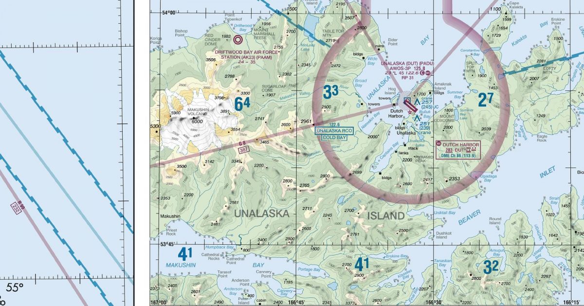
Go PROFrom Atka in the west to Unimak Island and the approaches to the Alaska Peninsula in the east, this sheet follows a long arc of the Aleutian chain. It includes the Unalaska and Dutch Harbor area, with the Bering Sea to the north and the North Pacific to the south. Flying here is defined by exposed ocean crossings, narrow island corridors and steep volcanic terrain rising abruptly from the coast.
The chart’s eastern side connects with both the Cold Bay and Kodiak sectionals. Cold Bay is the natural continuation for tracks following the island chain towards the Alaska Peninsula, while Kodiak supports routes heading farther east across the Gulf of Alaska. At roughly 400 nautical miles across, the Dutch Harbor sheet covers substantial distance, but longer journeys through southern Alaska will often require one of these adjoining charts.
| ID | Airport | City | Elev | Rwys | Longest |
|---|---|---|---|---|---|
| PAUT 7AK | Akutan | AKUTAN, AK | 129 ft | 1 | 4,500 ft |
| PAAK AKA | Atka | ATKA, AK | 55 ft | 1 | 4,500 ft |
| PADU DUT | Unalaska | UNALASKA, AK | 23 ft | 1 | 4,500 ft |
| PAKO IKO | Nikolski As | NIKOLSKI, AK | 76 ft | 1 | 3,512 ft |
| PAKF KFP | False Pass | FALSE PASS, AK | 18 ft | 1 | 2,150 ft |
5 public-use airports within this chart's coverage, ordered by runway length. A further 2 private and restricted landing facilities are not listed. Source: FAA NASR 28-day subscription.
Approach plates and airport diagrams for every airport in the states this sheet covers:
It spans 51.4°N to 56.3°N and 174.4°W to 163.1°W. Airports on the sheet fall within Alaska. The full list of public-use airports within its coverage is on this page.
Take the GeoTIFF if you are loading the chart into moving-map software or a flight planner — it is georeferenced, so the software can place it correctly on a map, and it ships with a world file and FGDC metadata at 300 dpi (16.9 MB). Take the PDF to print it or read it on a second screen (34.6 MB); it is the same chart without georeferencing.
This is the FAA edition effective 3 September 2026, which is superseded on 29 October 2026. Visual charts are reissued every 56 days and we publish each new edition on the day it takes effect. It is for flight simulation and reference only — not for real-world navigation.
Cold Bay to the east and Kodiak to the east. Each is linked from this page, so a route running off one edge can be continued on the next sheet.
Yes, with no account required. FAA charts are United States Government works and are not subject to copyright protection in the US under 17 U.S.C. § 105. Guest downloads are speed-capped, so a sheet this size takes a while; PRO members download at full line speed and can take the whole family as one archive.

FAA public-domain products, mirrored unmodified. Fly Away Simulation is not affiliated with or endorsed by the FAA. Chart licensing and terms.

