Page 5
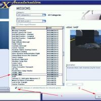
Searches the whole library — filter by sim & category on the results page
As Toshiyuki Watanabe, a JAL Express first officer, you fly JAL 1683 from Tokyo Haneda to Okayama aboard a Boeing 737-800. The flight plan is loaded, ATC directs you to proceed on your own course, …
Operates with the Acceleration expansion pack and requires installation of KC135T_NAVY_DROGUE.ZIP and USS_NIMITZ_IKE_VERSION2.ZIP plus SimVar.exe. The scenario places an F/A-18 Hornet aboard a carr…
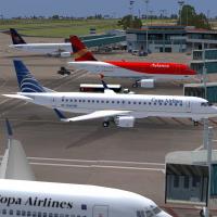
Passengers board a Copa service 559 bound for San Jose, Costa Rica; Tegucigalpa, Honduras; and Guatemala City through gate 59, preparing for a daytime connection among three Central American capita…
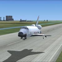
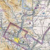
Approach activity culminates at NASA's Shuttle Landing Facility in Titusville, with the flight starting roughly fifty miles out and targeting a precise, controlled touchdown. It relies on SHUTXAJ.Z…
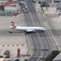
Two zip files accompany this Gibraltar scenario: mon321.zip, adding an Airbus A321 variant for Monarch Airlines operating to Gibraltar Airport, and gibraltar-1.zip, an add-on for effects. The airfi…
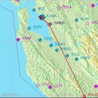
Carsten Wanzelius presents a real-world Airbus A320 scenario tracing JetBlue 241 from Oakland International to Long Beach, aided by a guiding copilot through procedures. It requires Wilco/FeelThere…
By Rob Opray, a two-exercise scenario places a USN carrier battle group alongside a USMC Expeditionary Strike Group in the Hawaiian Training Area to counter a rogue state. The mix features FA18, EA…
 Base Model
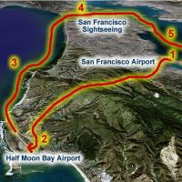
Chris Klein designs this scenario, pairing a Cessna 172 outing near San Francisco with an AI A380 model provided by Robert Versluys, aiming for a balanced intermediate experience. Concise voice cue…

Ten flights require an amphibian aircraft, traversing Alpine lakes from one to another and visiting well-known and lesser-known towns. Flight plans accompany the journey, and a briefing with notes …
An Embraer 120 by Premier Aircraft Design operates a Bordeaux to Lyon shuttle with stops in Lourdes, Andorra, Montpellier, Marseille, and Cannes. Two crew members, Lina and Juliett, accompany a ful…
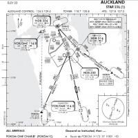
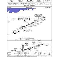
By Rob Sitter, this expert IFR training task places pilots at Auckland International Airport to execute a full STAR Arrival and ILS landing in challenging conditions. Approach charts are supplied, …
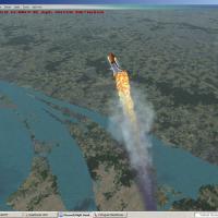
Space shuttle ascent scenario includes animations with timing effects and climbs to about 800,000 feet before the player may assume control, delivering a compact, self-contained high-altitude seque…
The IL-18, named Babaloo, leaves Dire Dawa International at 5:43 AM to begin a planned routing. The manifest specifies delicate cargo, including alligator skins and various small items, to be unloa…
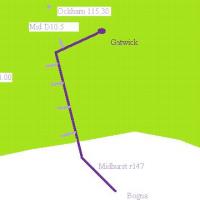
First Officer Phillip Breen of Thomas Cook Airlines flies a Boeing 737 toward Reus, guiding the flight with classic VOR navigation using Midhurst VOR (114.0) and Ockham, complying with altitude con…

A Cessna 172 flight leaves Dublin airport, flies to Malahyde Castle, then to the port and village of Howth, and returns to Dublin. The author is Pierre G. Shlimon, crediting the route through Dubli…
Drew Hosick presents a stranded passengers scenario, accompanied by the moosonee.gif image with dimensions 92 by 150 pixels. The piece centers on a compact, self-contained setup and relies on a sin…
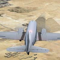
Lost Treasure, v1.1, situates the action in Cairo 1938 as you pilot a Douglas DC-3 Cargo. The setting relies on a Cairo 1938 backdrop and centers on piloting a Douglas DC-3 Cargo through a compact,…
A morning VFR run from Pangborn Memorial to a local airport unfolds under clear skies at 7:30 a.m. on Sunday. A Wizard folder is used for setup, with autogen set to zero and density at maximum.
Boeing 747 carries 248 passengers on a Kuala Lumpur to Perth leg just south of Jakarta, Indonesia, as it enters a volcanic ash cloud that causes lights outside the windows to fail and engines to fa…
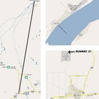
An almost midnight approach finds a Lockheed L-1011-200F descending toward JFK runway 31L from the southeast as a major thunderstorm pounds the New York area. By Angel Jared Vazquez, the setup reli…