Page 52
Searches the whole library — filter by sim & category on the results page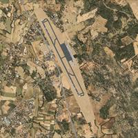
Granada-Jaen’s LEGR airport in Spain receives a redesign by Project JBG, updating taxiways, tarmac, buildings, fire station, car parks, people, vehicles, and vegetation to reflect a true airport la…
 Spain
Spain
At Kos Island’s Ippokratis Airport (LGKO) in Greece, the LGKO.BGL addon enhances the airfield with a runway, parking spots, taxiways, taxiway signs, turning bays, a windsock, and a fuel truck. The …
 Greece
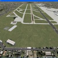
Seattle-Tacoma International (KSEA) gains v1.0 with a three-runway footprint, modifying the default airfield layout through added taxiways and a third runway. The configuration includes a new 16R/3…
 United States of America
Based at Bournemouth International (EGHH) in the UK, the project blends with default visuals and Just Flight's VFR layer, and adds extra GA parking plus FRA bays beside the north hangars. It employ…
 United Kingdom
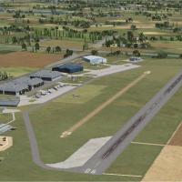
Three UK airfields—EGSU Duxford, EGSR Earls Colne, and EGFE Haverfordwest—receive improved layouts guided by Google Earth data and Pooleys UK Flight Guide, by Alf Denham. The work uses the default …
United Kingdom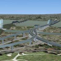
Version 2.00 adds the Olympic pyramid, the cross on Mont-Royal, the locks of St-Lambert, Champlain Bridge, and Honoré-Mercier Bridge, plus roads around the cross, by Sylvain Tremblay. The project r…
 Canada
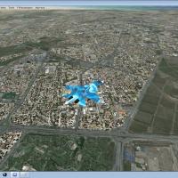
Version 2 of the Mashhad real-photo presentation delivers real elevation and all-season, night capability focused on the Mashhad area, anchored by the OIMM airport. Improvements include city traffi…
 Iran (Islamic Republic of)
Dynamic models by Terry Shields depict the HSS Stena Line car ferry on Belfast-Stranraer and Dun Laoghaire-Holyhead, plus the Norfolk Line car ferry Belfast-Liverpool, with timetables created using…
 Global (World)
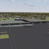
An add-on refines ground structures at Warsaw Chopin Airport (EPWA, formerly Okecie), with upgraded vehicle placements, extra cargo on the ramp, and taxiway routing tuned to mirror real-world opera…
 Poland
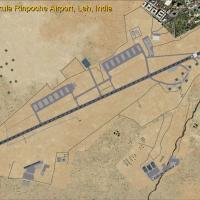
Version 1.3 of Leh Kushok Bakula Rinpoche Airport in Leh, India adds a GPS approach for runway 7 and expands the field with parking, taxiways, aprons, buildings, and roadways. Two helicopter bases …
 India
India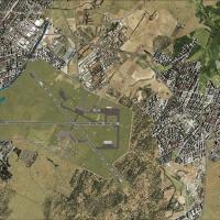
SVBC in Barcelona, Venezuela receives an enhanced airport environment that corrects taxiways and provides parking for GA and commercial aircraft, while adding more precise road networks and land cl…
 Venezuela (Bolivarian Republic of)
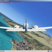
CanarFsX version 1 functions as a flight-simulation enhancement by Toni Agramont, emphasizing the physical details of the Canary Islands and supporting both VFR and IFR operations. This edition pre…
Spain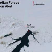
At CYLT near the North Pole, the airfield features a gravel runway 05-31 and a heliport. Designed with ADE 1.37, the layout adds an ice station along with tourist and military ships and icebergs, a…
Canada
By Francisco Urquia and Luis O. Bethencourt, CanarySim's Xporter handles PROJCA61.ZIP, PROJCA62.ZIP, and PROJCA63.ZIP, transferring their contents into CanarySim/Project Canarias 2006/Terrain - Dat…
Spain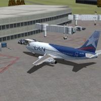
Version 7 of Chile revises SCEL with orientation tweaks and adjusted distances for taxiways, ramps, and gates, aligning with current layouts, and introduces Concepción Airport (SCIE). By J.N. Lucer…
 Chile
Chile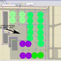
Two variants focus on the DHLComplex CVG and the DHL CArgo Annex at KCVG, offering a placeable option and night lighting for the facility near the Northern Kentucky/Greater Cincinnati International…
United States of America
An Eindhoven Airport depiction integrates with NL2000 coverage in the southern Netherlands, reconstructing hangars, terminals, and facilities around the apron and the main runway 03/21 with accurat…
 Netherlands
Alf B. Meier releases a targeted fix for Philip S. Goldson International Airport in Belize, using BGL files to remove autogen trees from the runway and taxiways. Generated with SBuilderX and Airpor…
 Belize
An airport enhancement for Belfast Aldergrove in Ireland adds updated parking, new objects including a fire station, and a repositioned control tower, paired with revised taxiways to reflect curren…
United Kingdom
Centered around KBLI in Washington, this depiction adds autogen and night lighting to the airport. Custom buildings replace airport structures, autogen and night lighting illuminate the scene, and …
United States of America