Page 9
Searches the whole library — filter by sim & category on the results page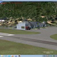
Valladier Jean-Louis provides a landclass overhaul for the Grenadines, requiring the MESHANTILLES.ZIP mesh and redesigning roads and coastlines across islands. It includes six St Vincent airports (…
 Global (World)
Unalakleet Airport (PAUN) in Alaska, version 3.0, stands as a completely custom build featuring animated smoke and a revised beacon system by Frits Beyer and Jacques Botha. Files include AFX_PAUN_A…
 United States of America
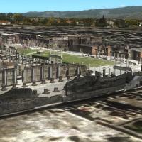
Sixteen 3D models depict the Pompeii ruins and Mount Vesuvius in a high-detail visual representation by Kevin R. Wynn. Pompeii ruin models are used with permission from Peter Olsen, tying the compo…
 Italy
Italy
A 2011 KDCA revision reassigns gates and redraws taxiways and aprons at Reagan National, eliminating intermittent concrete sections that produced frame-rate hits. It also encompasses the Anacostia …
United States of America
Ten Greek airfields are included, including LGKR Kerkyra, LGKF Kefallonia, LGZA Zakynthos, LGKC Kythira, LGIR Heraklion, LGST Sitia, LGIK Ikaria, LGLM Lemnos, LGPL Astypalaia, and LGKJ Kastelorizo.…
 Greece
By Lotar Tomczyk and Jakub Mista, this Krakow and Balice (EPKK) area enhancement presents the Old Town square and Wawel Cathedral among its landmarks, while including animated vessels on the Wisla …
 Poland
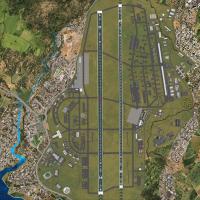
By Ian W, this freeware depiction covers Kadena AB (RODN) and five Okinawa airstrips, naming Yoron Island (RORY), Iejima (RORE), Aguni (RORA), Kumejima (ROKJ), and Kerama (ROKR). A flight plan runs…
 Japan
Japan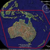
Thomas Trewin provides an SRTM terrain mesh covering Australia, New Zealand and PNG that updates the default landscape data with higher resolution. It uses the latest data available and fixes voids…
Global (World)Two RS variants exist for Arlanda's upgraded layout near Stockholm, Sweden, with ESSA_ADE_CW_RS.BGL enabling crosswind operations on runway 8/26 and ESSA_ADE_RS.BGL preserving default usage; both r…
 Sweden
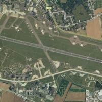
Located in the UK, RAF Mildenhall (EGUN) hosts the 100th Air Refueling Wing and stands as one of the largest overseas USAF installations, operating KC-135 Stratotankers and C-130s with transients c…
 United Kingdom
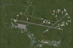
This depiction of RAF Mount Pleasant (EGYP) in the Falklands includes hangars, shelters, workshops, accommodation, and a night-lit magazine area. Layout based on Google Earth data from 2006; the ai…
 Falkland Islands (Malvinas)
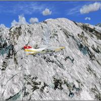
Global rock surfaces shift from 1 meter to 30 centimeter resolution, delivering finer detail across mountain regions worldwide and enhancing topographic cues for landscape comprehension. Only summe…
Global (World)
John Young of the Airfield Construction Group presents a RAF Marham airfield layout in the United Kingdom circa 1993, designed for use with Victor AI resources and Canberra AI resources, aligning w…
United KingdomTwo consolidated parts deliver an Everest massif revised by Frank Dainese, with the area encompassing Nepal’s high-altitude surroundings. The included .bgl files carry imagery for reliable loading,…
 Nepal
Nepal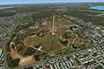
Three airfields in the Darwin region—Darwin International (YPDN), Royal Darwin Hospital helipad (YXDH), and Robertson Barracks (YRBK)—receive custom-built models and photoreal backdrops designed to…
 Australia
Renovation of MMMMX unfolds with a south side Terminal 2, assigned parking, and revised taxiways, implemented by Ray Smith using ADE v1.37 for the MMMMX project. A single BGL MMMMX.BGL controls the…
 Mexico
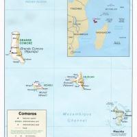
By Hely Heck Junior and Jose Lobo TerraBrasilis, Madagascar’s terrain data uses 90m SRTM2 data reprocessed with 3DEM to remove voids and spikes, yielding 76.4m horizontal resolution (LOD9). It cove…
 Madagascar
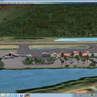
Valladier Jean Louis presents a Grande Case project that models the Grande Case (TFFG) airport and provides a more accurate Tintamare redesign, while remaining compatible with Caribbean mesh in LOD…
 Saint Martin (French part)
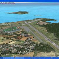
A redesigned layout focuses on more accurate coasts and updated landclass around V.C. Bird International Airport (TAPA) and the city of St. John's, with roads adjusting accordingly. By Valladier Je…
 Antigua and Barbuda
STRM terrain mesh for New Zealand removes voids across both islands. The nz-fsx-mesh folder holds the data, credited to J. Harris, and users may upload it to any web site or server without permissi…
 New Zealand