Page 15
Searches the whole library — filter by sim & category on the results page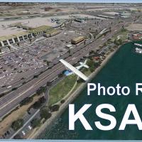
KSAN undergoes a complete rebuild using the latest ADE and SBuilderX tools, yielding the KSAN_PHOTO_REAL layout with a Terminal 2 expansion, new parking structures, and facilities along the runway …
 United States of America
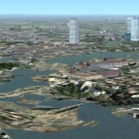
By Richard Ludowise and Luis Féliz-Tirado, modifications to terrain.cfg adjust water areas to avoid rocky appearances while keeping terrain heights intact. It colors the terrain rather than smoothi…
 Global (World)
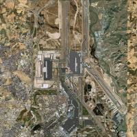
An understated addon enhances Barajas Airport in Spain by refining the LEMD visuals. It includes an AFX file and credits developer Miguel A. Perez Soria; the scope remains concise, focusing on the …
 Spain
Spain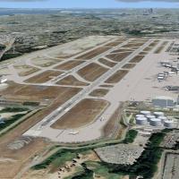
This revision updates SeaTac, Boeing Field (KBFI), Renton (KRNT), and Paine Field (KPAE) to align with MegaScenery Earth ground imagery, expanding the artificial plateau around SeaTac, adding a thi…
United States of America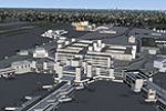
By Jake Benitez, KMIA receives a refinement that uses ADEX to alter the default KMIA facility in Miami, adding crosswind runways, revised taxiways, terminals and gates, extra taxiway signs, and fue…
United States of America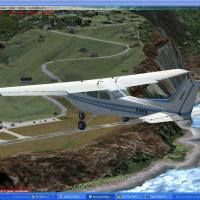
Coastal rework and land-class updates anchor the work on SABA airport and Fort Bay harbor, with roads and traffic recalibrated to land-class changes. Valladier Jean Louis credits the effort, notes …
 Bonaire, Sint Eustatius and Saba
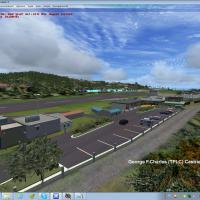
By Valladier Jean-Louis, coverage of Saint Lucia centers on two airports, George F. Charles (TLPC) and Hewanorra Int (TLPL), plus the Hess fuel storage area near Vieux Fort. It redefines coasts and…
 Saint Lucia
At Taoyuan Airport (ICAO RCTP, IATA TPE), Formosa X updates the layout with runways, taxiways, and aprons repositioned from satellite data, plus animated radars and people movers. Part 1 covers the…
 Taiwan, Province of China
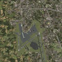
Two installation options exist, one for addon AI traffic and another for default AI, while the offering adds jetways on Pier B and C, hangars north of the field, and taxiways F-INN, F-OUT, Y, and M…
 Ireland
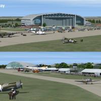
IWM Duxford in the UK shows detailed buildings on the airfield, with full customization from a quiet day to an optional air show. It features 20 representative AI aircraft and carries attribution b…
 United Kingdom
Frankfurt area facility in Germany gains a newly added runway 07L-25R, while an updated ILS, taxiways, and taxiway signage enhance navigation. Gates display numbers and parking positions receive gr…
 Germany
LFLJ airport enhancement adds custom buildings built in Gmax around the field and introduces a new runway angle, while AI aircraft follow flight plans crafted for this layout. Animation includes pe…
 France
At NAS Pensacola (KNPA) a project replaces every default building, adds Military_Cargo and Military_Combat parking spaces, relocates the control tower, and introduces a fire station with fire truck…
United States of America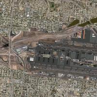
PHX airport gains a 2011 refresh featuring photoreal satellite imagery, moving jetways, and a Terminal 3 helipad beacon, while taxiways, ramps, and vehicle roadways are corrected and new vegetation…
United States of America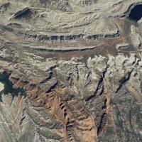
BlueSkyScenery crafts a Utah-wide photoreal terrain covering the entire state, including Canyonlands Airport and the Needles Outpost dirt strip. The coverage uses 1m/pixel imagery with a 10m high-r…
United States of America
An add-on for Frankfurt EDDF introduces Terminal A Plus and ILSZ/ILSY for runway 07L-25R, with up-to-date runway and taxiway signage as of January 2013. The v3 edition removes AI traffic from taxiw…
Germany
Photoreal rendition of New Orleans International Airport in Louisiana replaces the default KMSY layout using ADE, SBuilderX, and Google Sketchup. It adds the 2012 Concourse D expansion, a 2013 rent…
United States of America
CYUL_KA.bgl modifies CYUL on Island of Montreal to reflect Concourse A assignments and ramp parking, with added jetways and revised taxiway lighting. The modification defines all runways active, in…
 Canada
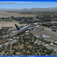
Kambiz Agazi reworks McCarran International (KLAS) by extending Terminal 1’s D gates to reflect Las Vegas operations. Two optional files, KLAS_ApproachLights07R.bgl and KLAS_ApproachLights19R.bgl, …
United States of America
Area 51 sits alone in the Nevada desert, operated since the Cold War by the U.S.A. and the CIA. The project, with Skara credited as the creator, starts from zero and now contains UFOs, custom objec…
United States of America