Page 26
Searches the whole library — filter by sim & category on the results page
TKPK gains new taxiways, a windsock, and the NDBDME Tower with revised aprons and paths, while airline gate numbers, locations, and assignments update per aerodrome observations and approaches incl…
 Saint Kitts and Nevis
In France, Le Castellet (LFMQ) stands as the Provence-Alpes-Côte d’Azur region’s largest private airfield, established in 1962 with a 1,000-metre runway later lengthened to 1,750 metres in 1972, en…
 France
Banff Airport (CYBA) sits in Alberta, Canada, and Daniel Louvet is the author. The listing also notes additional airfields such as CZBB Boundary Bay, CYCD Nanaimo, CYQQ Comox Valley, CYCZ Fairmont …
 Canada
By Shanard Letang, this addition for the airport at Camilo Daza in Cucuta, Colombia adds parking facilities north and south of the main terminal and introduces helicopter pads. Avianca's A320, regi…
 Colombia
An elevated airfield at Bangda in Qamdo, Tibet rises to 14,219 feet AMSL, marking it as the world's highest. By Anwar Gonzalez, it carries IATA BPX and ICAO ZUBD, features a 5,500 m asphalt runway …
 China
China
Landsberg Air Base in southern Germany hosts Lufttransportgeschwader 61 and sits as the focus of an updated stock layout crafted with ADE X 1.50, complemented by a fire station contributed by Malte…
 Germany
The project adds large oil refineries and chemical plants near England and Wales, making them visible navigation landmarks. A complete rewrite enables proper display, with Ted Andrews redesigning o…
 United Kingdom
Angel Falls sits in Canaima National Park, Venezuela, and stands as the world’s highest waterfall at 979 meters, a feature documented in 1933 by American pilot Jimmie Angel, with no mesh included b…
 Venezuela (Bolivarian Republic of)
Pablo Contouris presents a detailed depiction of Montevideo's coastal region along the Rio de la Plata, emphasizing harbor views and surrounding urban areas. The work relies on a freeware library f…
 Uruguay
Zell am See lies at a small GA-airfield near Salzburg, Austria, with AI traffic by Christopher Schenk; the author is Florian Berger. The layout features an asphalt runway of 660 meters and a smalle…
 Austria
At KOMA Eppley Field in Omaha, Nebraska, the project updates gates and parking, with jetways visible and operable and gate assignments aligned to current airlines and cargo ramps. Rob Touchtone cre…
 United States of America
Ardmore Aerodrome (NZAR) in New Zealand uses satellite data to position buildings and implements a precise layout for runways and taxiways, with the surrounding area extending beyond the aerodrome.…
 New Zealand
RJKI identifies Kikai Airport in Kagoshima, Japan, and anchors the entry with a geographic reference to the island city, along with an aerial view that accompanies it. Shigeru Tomino of Lets Fly As…
 Japan
Japan
Three locations update to Pensacola Carrier V2.0, including Oceana, Miramar, and Pensacola. NDB KNPC on deck serves both carriers at 245.0 kHz; LOC/DME KNPC 108.15 MHz; VOR PCGA 110.20 MHz, with 80…
United States of America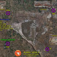
Armilla, Granada, Spain, hosts a base recreation for Ala 78 pilots with a low-detail layout including hangars, a control tower, and a fuel station; a higher-detail variant exists for Ala 78 Virtual…
 Spain
Spain
Two-part patch converts Shehryar Ansari’s FS2004 KLGA layout for New York’s La Guardia into FSX, packaged as klga_FSX with lga2004.zip and lga2004fix.zip. It removes two 2bgl files and adds three b…
United States of America
At MacDill AFB (KMCF) near Tampa, a revised layout adds parking spaces, a fire station with trucks, helipads, and static fork trucks, replacing the five main hangars with more realistic ones. It us…
United States of America
By Chris Carel, this freeware project marks the Southern Crossing, designating AP and SP locations across the southern United States, including KYUM Yuma International, KGEU Glendale, KLCH Lake Cha…
United States of America
Near Buffalo, New York, the main terminal gains expanded gates, jetways become visible, and a cargo-area section with trucks appears along the apron. A general aviation terminal includes many stati…
United States of America
Ellington Field (KEFD) in Houston, Texas, serves civil operations and hosts the Texas Air National Guard, the Texas Army National Guard, the US Coast Guard, NASA, and UPS. Two files, AFX_KEFD_JC.bg…
United States of America