Page 5
Searches the whole library — filter by sim & category on the results page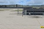
LSZH in Switzerland appears in the V2 edition with a frame rate friendly layout. Terminals A, B and E gain gate-number signs and ground-painted taxiway markers for clearer orientation, while the up…
 Switzerland
Conifer, seasonal, and tropical forest imagery are included, with global coverage and a shift from 1 meter to 30 centimeters in resolution. Only summer imagery is available, and the archive include…
 Global (World)
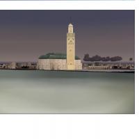
Version I by Toni Agramont adapts the Moroccan and Sahara region across Nouadhibou in Mauritania to Cebta in the north and Oujda in the east near Algery. It includes 36 airports that are totally re…
 Morocco
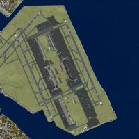
Ray Smith provides two RJTT variants, RJTT_ADE_CW_RS.BGL and RJTT_ADE_RS.BGL, enabling a crosswind activation approach or preserving two parallel runways for arrivals and departures. The crosswind …
 Japan
Japan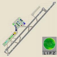
Venice Tessera airport at LIPZ in Italy aligns its layout with Jeppesen parking charts and the AIP Italy, based on real-world photos, and credits Claudio A. Dobre. The design converts RWY 4L/22R in…
 Italy
Italy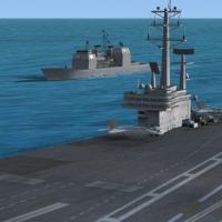
Moving naval ships circulate as AI traffic at locations worldwide, including Norfolk VA, Jacksonville FL, Napoli Italia, and Atsugi Japan. A carriers.kml file helps locate groups, most sit 10-40 nm…
Global (World)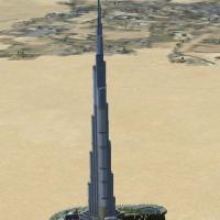
Burj Dubai sits just southeast of OMDB and stands as the world’s tallest building. Andy Johnston converts the data from Google Earth and produces a geographically accurate model of the structure fo…
 United Arab Emirates
Antonio Baeli presents Catania Fontanarossa Airport in Italy, identified by LICC, with its location and identifier noted and illustrated through an accompanying visual. The presentation anchors on …
Italy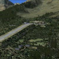
Version 2.0 presents four alpine altiports with sloped runways: LFHM Megeve, LFKX Meribel, LFHU Alpes d'Huez, and LFLJ Courchevel, all authored by Guy Nemoz. The project uses Alps LOD11 freeware me…
 France
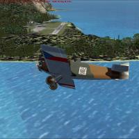
Colin Dietrich delivers a rework of Saba Island, producing three .bgl files for two locations: SABA_ADE_CD.bgl, SABA_ADE_CD_CVX.bgl, and saba_newheight.bgl, which raise the airport height to 18m/60…
 Bonaire, Sint Eustatius and Saba
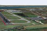
Five BGL files form this Liverpool EGGP grouping, including an airfield file and a flattening file. The 125-object file carries zero POIs, while the 27-object file covers additional static content,…
 United Kingdom
The airfield near Bristol in the UK, designated EGGD, is modeled with Gmax for buildings, ADE9X for taxiways and gates, and samm for static aircraft. Static aircraft and 2D passengers and ground st…
United Kingdom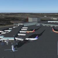
Bradley airport (KBDL) in Windsor Locks, CT gains a remapped gate layout with an extended A-Concourse and added jetways, plus a Marriott hotel, parking structure, and an old control tower nearby, w…
 United States of America
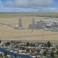
Two runway-operation options accompany three BGL files for KSLC: KSLC_RS.BGL, KSLC_CW_RS.BGL, and KSLC_CVX.bgl. The Crosswind version enables 14/32 with all four runways active, while the default f…
United States of America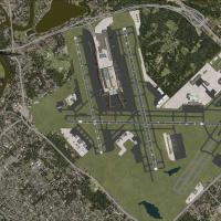
Focused on KMSP in Minnesota, the layout features ramp lights and moving ground traffic around airside areas, by Jimmy R. Martin. The emphasis centers on the airport's active zones and surrounding …
United States of America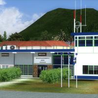
An authentic representation covers St. Eustatius with a photoreal terminal, control tower, and PIR for the F.D. Roosevelt (TNCE) in Oranjestad, created by JL Valladier and credited to Harald Sandvi…
Bonaire, Sint Eustatius and Saba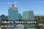
Volume 1 covers most skyscrapers along Jl. Jend Sudirman and Jl. HR Rasuna Said in Jakarta, Indonesia. By Budi Santoso, it converts SketchUp models created for Google Earth into a flight simulator,…
 Indonesia
Graham Michael presents 22 airfield enhancements for Papua New Guinea, featuring redesigned layouts, added parking, and updated aprons. Airfield objects are upgraded, including terminal buildings a…
 Papua New Guinea
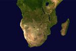
By Hannes Steyn, Johan van Wyk, Aeroworx, this trio of base-grid files spans Africa-area coverage south of the equator with Mauritius, Madagascar, Comoros, Reunion Island, and Tromelin included: fs…
Global (World)
A fixed update for Sofia International Airport in Bulgaria introduces new building coordinates and keeps all navaids functioning, drawing on a prior release for reference and carrying the airport c…
 Bulgaria