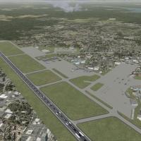
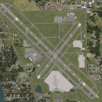
United States of America

Page 18

Sort
Reset
Preview screenshot

Telluride Regional Airport

Telluride Regional Airport (KTEX) scenery for FSX/Acceleration adds photoreal seasonal textures, high-resolution terrain mesh and ground-poly runways to north-western Colorado’s 9,078-ft MSL airfield, pairing custom 3-D structures, subdued lighting effects and corrected elevation data for smooth approaches, steady frame rates and realistic mountain-operations training.

File Size
31.59 MB
Total Downloads
2.1K
Star Rating
3/5
Screenshots
3
Preview screenshot

MCAS Miramar - Mitscher Field

Scoped rebuild of MCAS Miramar – Mitscher Field places the USMC’s San Diego aviation hub inside FSX and Prepar3D, layering refreshed aprons, Hangar 7, twin vertical landing pads, the southeast LHD deck mock-up, FA-18 hardstands, V-22 Osprey pads and early F-35 infrastructure, supported by native models, custom night lighting and an AFCAD optimised for AI traffic.

File Size
53.08 MB
Total Downloads
2.1K
Screenshots
3
Preview screenshot

FlightZone02 Portland Scenery Patch

This lightweight patch repurposes FlightZone02 Portland (FS2004) for Microsoft Flight Simulator X, supplying revised AFX airport geometry, fresh exclusion BGLs and FSX-native autogen tree calls across KPDX, KHIO, KTTD and KVUO, giving Oregon, USA flyers smooth compatibility with Orbx NA Blue PNW and other Pacific Northwest photoreal landclass sets, all offered as freeware.

File Size
506.56 KB
Total Downloads
2.1K
Star Rating
5/5
Screenshots
1
Preview screenshot

Texture Mod - Southwestern USA Desert Textures, V1.00

FSX Texture Mod – Southwestern USA Desert Textures V1.00 refreshes Region C landclass calls 003c2, 009c2 and 051c2 with greener xerophytic shrub layers, nuanced cactus patterns and denser woody scrub, giving Phoenix-north foothills, Sedona’s red outcrops and Grand Canyon benches a truer semi-arid palette while retaining default autogen fidelity.

File Size
283.77 KB
Total Downloads
2.1K
Star Rating
5/5
Screenshots
2
Preview screenshot

Lexington Photoreal

Covering roughly 245 sq mi of Kentucky’s Bluegrass Region, this 1 m/pixel daytime terrain add-on supplies high-resolution photoreal textures for Lexington’s city core, Bluegrass Airport, Keeneland, horse-farm belt and UK campus, blending georeferenced USGS imagery with stock FSX mesh and water polys for stutter-free VFR circuits in FSX or P3D.

File Size
648 MB
Total Downloads
2.1K
Star Rating
4/5
Screenshots
17
Preview screenshot

Charleston AFB

Updated Charleston Air Force Base / International Airport KCHS for FSX offers a reworked AFCAD layout with true-to-chart taxiway geometry, dedicated C-17 Globemaster III parking, visiting military and cargo bays, coded jetway gates, GA apron spots, LAHSO runway intersections, corrected signage and AI-compatible traffic flow for this South Carolina joint-use field.

File Size
709.45 KB
Total Downloads
2K
Star Rating
4/5
Screenshots
6
Preview screenshot

Southern California

Covering SoCal from Los Angeles through San Diego, Riverside, Palm Springs and up to Big Bear with spill-over into western Arizona, this FSX package deploys high-resolution photoreal textures, custom autogen, accurate elevation mesh and corrected coastlines, giving VFR and IFR flyers reliable geographic cues across dense urban and desert terrain.

File Size
1002.59 MB
Total Downloads
1.9K
Star Rating
4/5
Screenshots
1
Preview screenshot

Nashville International Airport

FSX-specific rendition of KBNA Nashville International updates terminal layouts, gate numbering, operational jetways and airline-accurate parking stands, compiled with ADE for SP2. Cargo aprons, signage and extra static details match current charts, and the package integrates cleanly with WoAI or other AI traffic without further libraries.

File Size
43.11 KB
Total Downloads
1.9K
No image available.

Southern California Scenery Enhancement

FSX Southern California Scenery Enhancement v2.0 groups KMHV Mojave, KTSP Tehachapi Municipal, KVBG Vandenberg AFB, Palm Springs turbine fields and updated offshore oil platforms into one regional package, adding photoreal ground polys, accurate AFCADs and integrated Rwy12 object textures for seamless compatibility across Microsoft Flight Simulator X airports.

File Size
39.71 MB
Total Downloads
1.9K
Preview screenshot

NAS Corpus Christi

Naval Air Station Corpus Christi for Microsoft Flight Simulator X SP2/Acceleration delivers a detailed Gulf Coast military flight line: VT-27/28 T-34 Mentor ramps, VT-31/35 T-44 Pegasus and UC-12 Huron aprons, Coast Guard seawall base, Army rotorcraft depot and Homeland Security surveillance outpost, with native GMax objects, photoreal ground masks and optional car/rotor BGLs for frame-rate control.

File Size
44.02 MB
Total Downloads
1.9K
Screenshots
4
Preview screenshot

Mt Washington And The Presidential Range Photo

Mount Washington & Presidential Range Photo Scenery for Microsoft Flight Simulator X adds 1 m/pixel photo-real textures and enhanced terrain mesh to northern New Hampshire’s White Mountains, covering the 6,288-ft summit, adjacent ravines, Crawford and Pinkham Notches, with an orientation map referencing nearby fields KHIE, KBML and alpine bush strips for accurate VFR navigation.

File Size
314.52 MB
Total Downloads
1.9K
Star Rating
5/5
Screenshots
6
Preview screenshot

V1.01 NAS North Island

Serving San Diego’s NAS North Island (KNZY) naval base, this Microsoft Flight Simulator X v1.01 scenery updates the original with 1 m photoreal orthoimagery, SP2-compliant vegetation, removable static aircraft and carrier deck, plus an AFCAD-tuned layout matching current charts. Delivers smooth frame rates for carrier traffic, helicopter circuits and SoCal VFR training.

File Size
26.99 MB
Total Downloads
1.9K
Star Rating
5/5
Screenshots
5
Preview screenshot

San Diego Buildings Part 1

Covering downtown San Diego, Balboa Park and Little Italy, this FSX scenery injects custom landmarks and accurate skyline models tuned for MegaScenery Southern California; optimized draw calls keep frame-rates steady on final into KSAN while providing reliable VFR reference points, night lighting and aligned autogen for both GA circuits and IFR approaches.

File Size
398.83 MB
Total Downloads
1.9K
Screenshots
3
Preview screenshot

USA 10 M Terrain Project

Covering the United States West Coast, this freeware FSX scenery mesh replaces the default 38 m digital elevation data with sharper 10 m terrain across six numbered segments; Version 1.1 merges the Palm Springs fix, compiled via MultiLOD from NED DEM for cleaner ridgelines, valleys, and VFR navigation.

File Size
1.98 GB
Total Downloads
1.8K
Star Rating
5/5
Screenshots
2
Preview screenshot

KSAN Photo Real

KSAN Photo Real Scenery for FSX refreshes San Diego International, delivering high-resolution ortho imagery, a revised AFCAD compiled with ADE v1.51, real-world runway 09 ILS 111.55 alignment, updated ground-service paths, refined stand allocations, and accurate coastal palm placement, provided as a compact BGL patch designed to layer over the base KSAN_RR_v1 scenery.

File Size
907.21 KB
Total Downloads
1.7K
Star Rating
5/5
Screenshots
2
Preview screenshot

Idaho Photoreal

Photorealistic Idaho package supplies 50 cm/px aerial textures for nearly the entire Gem State, matching FreeMeshX or default terrain while preserving autogen around Boise KBOI, Mountain Home AFB KMUO, Craters of the Moon lava fields, and rugged Sawtooth backcountry strips; a straightforward VFR scenery upgrade for flight-sim pilots on FSX, Steam Edition or P3D v4.

File Size
33.57 GB
Total Downloads
1.7K
Star Rating
4/5
Screenshots
47
Preview screenshot

Sheppard Air Force Base

KSPS Sheppard AFB / Wichita Falls International scenery for FSX depicts the high-tempo NATO training base with custom hangars, dual ILS runways, detailed taxiway geometry, civilian terminal integration, calibrated night lighting and static T-6A Texan II plus T-38C Talon models, matching North Texas traffic flows and surface markings.

File Size
13.63 MB
Total Downloads
1.7K
Star Rating
5/5
Screenshots
7
Preview screenshot

Portland Internatioal Airport

FSX iteration of Portland International Airport (KPDX) refreshes the Columbia River hub with a re-scaled terminal, precise gate coding for FedEx, UPS and mainline carriers, repositioned ATC tower, realistic parking structures and ADE-based taxiway geometry tuned for World of AI and UTX compatibility.

File Size
23.34 KB
Total Downloads
1.7K
Preview screenshot

Juneau International Airport

Juneau International Airport (PAJN) scenery for Microsoft Flight Simulator X upgrades the default field with a supplemental ILS on 08, re-drawn aprons, added GA stands, refreshed terminals and a landclass bridge off the upwind threshold; refined AFCAD, parking codes and lighting create a credible IFR gateway for Alaskan bush or regional jet operations.

File Size
239.67 KB
Total Downloads
1.6K
Screenshots
1
Preview screenshot

Minneapolis/St. Paul Airport Scenery Update

Adding runway 17/35, revised taxiway geometry, refreshed signage, calibrated ILS/LOC beacons, plus updated apron lighting and parking codes, this FSX Minneapolis–St Paul (KMSP) scenery refresh brings the Minnesota hub in line with current charts and feeds AI traffic with SID/STAR and coded approach procedures for steadier virtual airline flow.

File Size
629.9 KB
Total Downloads
1.6K
Star Rating
5/5
Screenshots
1

55 pages with 1097 downloads.

previous1234567891011121314151617181920212223...5455next