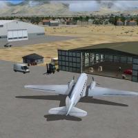
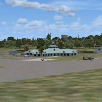
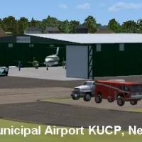
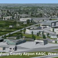
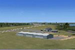
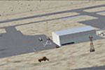
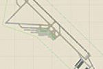
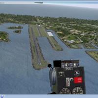
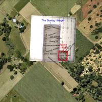
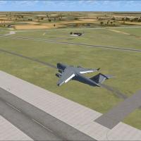
United States of America

Page 44

Sort
Reset
Preview screenshot

W91 And Smith Mountain Lake

Covering Smith Mountain Lake Airport W91 and the adjacent VA48 water runway, this United States flight simulator scenery download refines FSX SP2 with custom RWY12 objects, updated terrain mesh, marina textures, and photoreal reference points across the reservoir southeast of Roanoke—suited to GA circuits, floatplane touch-and-go practice, and VFR navigation.

File Size
4.07 MB
Total Downloads
149
Preview screenshot

New Castle Municipal Airport

Covering Union Township’s 320-acre KUCP field, this Microsoft Flight Simulator X SP2 scenery refreshes New Castle Municipal Airport with revised AFCAD, EZ-Scenery libraries, ramp lighting, GA parking and default AI schedules, aligning both asphalt runways, Haski Aviation FBO details and surrounding Pennsylvania landscape.

File Size
881.76 KB
Total Downloads
148
Star Rating
4/5
Screenshots
2
Preview screenshot

Ely Airport/Yelland Field

Targeting Microsoft Flight Simulator X flyers, this Nevada scenery overhauls Ely Airport–Yelland Field (KELY): an ADE 9X AFCAD that syncs runway headings, taxiway links and signage with current FAA data, introduces Ely Jet Center FBO, custom Jim Dhaenens ramp lighting, refined apron markings, correct gate numbering and GA stands for regional Great Lakes Airlines commuter traffic.

File Size
10.78 MB
Total Downloads
146
Preview screenshot

Allegheny County Airport

Covering West Mifflin’s Allegheny County Airport (KAGC), this FSX-native enhancement ports the original FS2004 package to Microsoft Flight Simulator X, adding updated AFCAD layout, photoreal ground polys, default-based AI schedules and night lighting—useful for regional GA pilots, corporate jet routes and Pittsburgh reliever ops.

File Size
616.43 KB
Total Downloads
146
Screenshots
2
Preview screenshot

Lowry AFB

FSX Lowry AFB Scenery resurrects the long-retired U.S. Air Force training field in Illinois with a revised AFCAD layout, accurate runway placement, custom hangar models, updated taxiway network, AI parking codes and night lighting—ideal for VFR circuits or instrument practice. The package enriches Midwest military airport coverage for Microsoft Flight Simulator X users.

File Size
321.25 KB
Total Downloads
146
Screenshots
1
Preview screenshot

Mustang Beach Airport

Mustang Beach Airport KRAS for Microsoft Flight Simulator X supplies an updated coastal Texas general-aviation hub at Port Aransas, translating and expanding the earlier FS9 build via ADEX: corrected 3,497-ft runway 12/30 data, tidied taxiway links, added transient parking, and stock-library scenery objects tuned for Ultimate Terrain X, Active Sky, and other environment plug-ins.

File Size
712.83 KB
Total Downloads
146
Screenshots
4
Preview screenshot

Finger Lakes Regional Airport

Covering the upstate New York airfield 0G7, this FSX scenery sets correct taxiway geometry, revised aprons, custom hangars and small GA terminals, layering static GA traffic, service vehicles and ground clutter that align with current AirNav plates and Google Earth imagery; designed around default libraries, integrates neatly with Ultimate Terrain X or comparable landclass products.

File Size
15.88 KB
Total Downloads
145
Star Rating
2/5
No image available.

O'Hare International Airport Update

Chicago O’Hare Airport scenery upgrade (KORD) for FSX realigns runway 27L/9R to 28/10 and revises Terminal 2, mirroring current gate allocations for United, United Express and partner airlines; an AFCAD-style refresh that refines taxiway links, parking stands and gate coding for a more accurate Illinois hub layout.

File Size
38.36 KB
Total Downloads
144
Preview screenshot

Fulton County Airport

Covering Fulton County Airport (NY0) in Johnstown, New York, this FSX scenery add-on replaces default assets with accurate aprons, corrected boundary fencing, GA parking and real-world runway paint, while AFX and Instant Scenery inject hangars, a riverside restaurant, flagpole, new water tower and RWY12 static aircraft for plausibly busy ramp operations.

File Size
6.61 KB
Total Downloads
144
Star Rating
1/5
Preview screenshot

Hopedale Industrial Park

Covering Hopedale Industrial Park Airport (1B6) in Massachusetts, this FSX scenery enhancement supplies the 3 173-ft runway, revised taxiways, four GA stands, functional fuel point, plus stock-object renditions of Rosenfeld Concrete, Draper Mill and surrounding industrial estate, adding VFR waypoints and secondary roads toward Milford—built in ADE, no extra libraries, meshes or terrain packs needed.

File Size
4.66 MB
Total Downloads
143
Star Rating
1/5
Screenshots
3
Preview screenshot

Henrys Lake Airport

Henry’s Lake Airport U53 for Microsoft Flight Simulator X updates this Idaho, USA bush strip with improved terrain mesh, photoreal textures and 486-plus stock objects, featuring paved RWY 6, ILS and ATIS, plus shoreline camps, drift boats and trout-fishing spots across 25 square miles bordering Yellowstone for GA and float operations.

File Size
1.55 MB
Total Downloads
143
Star Rating
1/5
Screenshots
35
Preview screenshot

Harris Hill Gliderport

Harris Hill Gliderport (4NY8) scenery for Microsoft Flight Simulator X and FSX-SE refreshes Elmira, New York’s renowned soaring hub with twin grass runways, AirNav-aligned coordinate data, custom hangars, static Schleicher sailplanes, service vehicles and a corrected taxiway schema, tuned for Ultimate Terrain X and default mesh.

File Size
14.23 KB
Total Downloads
143
Star Rating
1/5
Preview screenshot

Amherst Massachusetts

Covering Amherst, Massachusetts—including the UMass campus—this FSX-native .bgl by Dick Kittredge drops accurately geo-referenced buildings onto the Ultimate Terrain USA mesh, created with Flight1 Instant Scenery for seamless autogen blending, seasonal ground textures and precise road alignments, giving VFR pilots a reliable visual reference north of KBAF.

File Size
3.07 MB
Total Downloads
143
Preview screenshot

Jack Brown's Seaplane Base

Wetland flying around Central Florida gets a detailed update with this FSX-only scenery of Jack Brown's Seaplane Base (F57) in Winter Haven, delivering a photo-aligned water runway, custom hangar and FBO, static Piper J-3 Cubs, C185 floatplane, and docked craft for authentic US float operations.

File Size
1.24 MB
Total Downloads
143
Preview screenshot

AFX File For KRME

Covering the 2006 shift from Oneida County’s KUCA to Griffiss Air Park (KRME) in Rome, New York, this AFX update for FSX/Prepar3D supplies precise ramp geometry, AI parking stands keyed to AFCAD protocol, and representative static B-52–era aircraft support hardware, integrating the enlarged former SAC base smoothly into contemporary Northeastern U.S. traffic patterns.

File Size
10.56 KB
Total Downloads
142
No image available.

Metro Oakland Int'l Airport

Metro Oakland International Airport (KOAK) in Northern California receives updated FSX default scenery AFCADs featuring optional crosswind runway logic, animated jet bridges, enlarged GA helipad, rebuilt vehicle service roads, extra fuel trucks, accurate coded parking, and a south-tower rooftop camera position, fully aligned with Ultimate Traffic, WOAI and other AI schedules.

File Size
40.24 KB
Total Downloads
142
Preview screenshot

Steven F. Udvar-Hazy Center

Anchored on the Smithsonian annex at Washington-Dulles (KIAD), this FSX scenery places the Steven F. Udvar-Hazy Center’s Boeing and Space hangars, populates them with static Concorde, SR-71, 747 stand-in, and other museum aircraft, and aligns the structures with airport taxiways, realistic tarmac markings, and northern Virginia photoreal ground.

File Size
4.1 MB
Total Downloads
142
Star Rating
1/5
Screenshots
1
Preview screenshot

St. Marys Municipal Airport

KOYM St. Marys Municipal Airport for FSX brings Elk County’s 283-acre GA field into sharper focus with a rebuilt 4,300 × 75 ft asphalt 10/28, corrected drainage, custom hangars, ramp lighting, landclass tweaks, static and optional AI traffic, AFCAD refinements, and accurate nav-aid placement for Pennsylvania hops.

File Size
1.06 MB
Total Downloads
141
Star Rating
4/5
Screenshots
2
Preview screenshot

Nenana Municipal

Winterized Nenana Municipal Airport (PANN) for Microsoft Flight Simulator X updates aprons, taxiways and the Tanana River water strip—now rendered as an ice runway—while snow textures cover former grass and dirt surfaces; satellite-matched layout, smoke-emitting structures and a static service truck round out this Alaska bush-flying enhancement.

File Size
1.19 MB
Total Downloads
140
Screenshots
4
Preview screenshot

Eastern Sierra Regional Airport

Covering Bishop’s Eastern Sierra Regional Airport (KBIH) in California, this FSX add-on realigns runway 12/30, taxiways, aprons and parking to geospatially correct positions, relocates hangars and GA facilities using Google Earth footprints, injects stock-library objects for ambience, and compiles via Airport Design Editor for dependable approaches amid Owens Valley’s high-desert Sierra Nevada setting.

File Size
323.27 KB
Total Downloads
140
Screenshots
1