Terminal Procedures

KDYS — Dyess AFB

ABILENE, TX · 12 FAA charts · cycle 6 Aug 2026

FAA DYSElevation 1,790 ft3 runwaysLongest 13,500 ftToweredFuel Jet A+Volume SC-2Not for navigation
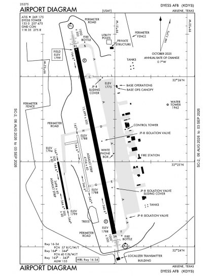
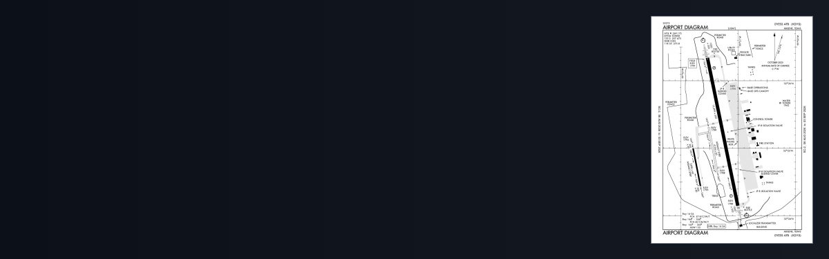
KDYS airport diagram — runways, taxiways and ramp layout
KDYS airport diagram The official FAA airport diagram — runways, taxiways, ramp layout and hold-short positions. Download PDF

10 published instrument approaches: 4 ILS approaches, 2 VOR, serving 2 runway ends.

All 12 KDYS charts in one download Every approach, departure, arrival and minimums page for this airport, sorted into folders, as a single ZIP. Taken one at a time on the free tier, 12 charts is roughly 1 min of downloading — they queue one behind another.
PRO members only

Instrument approach procedures

ChartAmendment
HI-ILS OR LOC X RWY 16 chart previewHI-ILS OR LOC X RWY 16PDF
HI-ILS OR LOC X RWY 34 chart previewHI-ILS OR LOC X RWY 34PDF
HI-TACAN X RWY 16 chart previewHI-TACAN X RWY 16PDF
HI-TACAN X RWY 34 chart previewHI-TACAN X RWY 34PDF
ILS OR LOC W RWY 16 chart previewILS OR LOC W RWY 16PDF
ILS OR LOC W RWY 34 chart previewILS OR LOC W RWY 34PDF
TACAN W RWY 16 chart previewTACAN W RWY 16PDF
TACAN W RWY 34 chart previewTACAN W RWY 34PDF
VOR/DME RWY 16 chart previewVOR/DME RWY 16PDF
VOR/DME RWY 34 chart previewVOR/DME RWY 34PDF

Takeoff and alternate minimums

ChartAmendment
RADAR MINIMUMS chart previewRADAR MINIMUMSPDF

Minimums pages cover a whole volume, so the same document is shared by every airport in it.

KDYS airport information

Control tower
Yes
ARTCC
Fort Worth Center
Flight service
Fort Worth
NOTAM facility
FTW (NOTAM-D available)
Magnetic variation
5E
Beacon
White-green (lighted land airport), sunset to sunrise
Wind indicator
Yes
Fuel
Jet A+
Airframe service
Major
Powerplant service
Major
Bottled oxygen
None
Ownership
Privately owned
Sectional
Dallas-Ft Worth

From the FAA NASR 28-day subscription, cycle 6 Aug 2026.

KDYS radio frequencies

ServiceFrequencyCall sign
Tower133.0Dyess
Ground118.35Dyess
Approach125.0East127.2WestDyess
Emergency121.5Dyess

Civil VHF frequencies from the FAA NASR 28-day subscription. Discrete sector and military frequencies are not listed.

Runways

13,500 × 300 ft16343,500 × 60 ft1633433,498 × 60 ft164344N2,000 ft
Runway layout at KDYS, drawn to scale from FAA published runway-end coordinates and true alignments. Runways served by an ILS are highlighted.
RunwayLengthWidth SurfaceLighting
16/3413,500 ft300 ftConcreteHigh intensity
  16ILS · PAPI (4-box) 2.6° · ALSF-1 approach lighting
  34ILS · PAPI (4-box) 2.5° · ALSF-1 approach lighting
163/3433,500 ft60 ftDirt
164/3443,498 ft60 ftAsphalt

Runway and approach-aid data from the FAA NASR 28-day subscription.

Where KDYS is

Latitude, longitude32.4184760, -99.8565450
Elevation1,790 ft
From Abilene5 nm SW

Paste the coordinates into a simulator’s world map to drop straight onto the field.

FAA remarks for KDYS

  • RSTD: INBD ACFT WITH DV CODE 6 OR ABV CTC AFLD OPS 20 MIN PRIOR ARR MON-FRI, CTC COMD POST ON UHF OR DSN 461-1921. 45 MIN PRIOR WKEND AND HOL.
  • TPA: 1210 FT AGL RECTANGULAR, 1710 FT AGL OVERHEAD.
  • RWY LNDG ZONE CLSD.
  • CAUTION: INTS TRNG AND FORMATION FLT OF HVY ACFT IN THE IMMED VCNTY.
  • MISC: ALL AMC ACFT CTC AMCC PRIOR TO ARR DSN 461-1984, C325-696-1984..
  • PPR CTC AFLD MGMT AT 7OSS.OSAA.AMOPS@US.AF.MIL FOR PPR REQ FORM DSN 461-2515/2258. MIN 24 HR NOTICE RQR AND REQ NO MORE THAN 7 DAYS PRIOR. PPR VALID +/- 30 MINUTES OF SKED LDG. ALL DIVERTS MUST CTC AFLD MGMT TO CONFIRM RAMP SPACE/TRAN SVC AVBL.
  • CSTMS/AG/IMG: CSTMS AVBL, CTC SECURITY FORCES DSN 461-2131/2132 24 HR IN ADVANCE.
  • CAUTION: ACFT LRGR THAN C130 ONLY ALLOWED 180 DEG TURNS ON CONC SFC AT N AND S ENDS OF RWY 16-34.
  • TFC PAT: DUR VMC DEP ACFT MUST REMAIN AT OR BLW 3000' TIL FLD BDRY TO ENSURE SEPARATION FR VFR OVERHEAD.
  • BEARING STRENGTH RWY 161-341: AUW 155.
  • TFC PAT: RSRS APPLIES TO ALL LOCAL ACFT. B1 8000', C130 5000' SEPARATION, B1 RQR MIN CEIL/VIS 1500'/3 SM AND RWY SFC DRY.
  • JASU: 1(MD-3) 1(A/M32A-60A) 1(A/M32A-86) 1(A/M32A-95).
  • FLUID: LPOX DE-ICE.
  • OIL: O-133-148-156.
  • CAUTION: EXTV VFR ASSAULT STRIP TFC W OF RWY 16-34.
  • CAUTION: AFLD SIGNS RQR B52 ACFT EXIT RWY 16-34 AT TWY F.
  • SERVICE: TRAN ALERT SVC AVBL MON-FRI 1400-0400Z++; CLSD WKEND AND HOL.
  • CAUTION: DURING BWC MODERATE AND SEVERE, AIRCREWS SHOULD COMPLY WITH OWNING MAJCOM/UNIT GUIDANCE; AIRCREWS CAN OBTAIN CURRENT BWC FR ATIS/PTD. BASH PHASE II IN EFFECT APR - JUN AND SEP - NOV.
  • CAUTION: COMSEC STORED AT COMMAND POST.
  • RSTD: NO ARR/DEP WHEN LIGHTNING WI 5 NM WO OG/CC APVL.
  • RSTD: QUIET HR POLICY 0400-1000Z++.
  • MISC: AFLD WX MNT BY AN/FMQ-19 ASOS, AUGMENTED BY HUMAN OBSN WHEN RQR. ATC WILL RELAY TWR PREV VIS, RCR/RSC AND VIRGA RMK TO ACFT. AUGMENTED SFC VIS RSTD 090-160 BY BLDG.
  • MISC: FOR CUSTOMS REFER TO FCG OR AP-1.
  • RSTD: PPR VALID +/- 30 MINUTES. PPR WILL NOT BE ISSUED FOR TRAN ACFT REQ RWY 163/343 AND RWY 164/344. LZ164/344 HAS A NON-STD LTG SYS. TRAN ACFT MUST OBTAIN BRIEFING FM 317 OSK PRIOR TO NGT OPNS. WITHOUT FORMAL NOTIFICATION FROM 317 OSK, TRAN ACFT USING RWY 163/343 OR 164/344 AT NGT WITHOUT LGT (OVERT OR COVERT) AND WITH RESPECTIVE MAJCOM/A3 APVL MUST NOTIFY AFLD MGMT AND REQ SEPARATE NOTAM FOR UNLGTD LZ OPNS.
  • PARK SPOTS A1 AND B1 USED FOR TAXI OPNS ONLY.
  • RSTD: PRK SPOTS A12, A13 AND A20 ARE DESIGNATED ACFT GRD EQPT (AGE) SPOTS.
  • RSTD: TYE RAMP CLSD.
  • RSTD: TWY G RSTD TO DAYLT OPS ONLY; EXC NVG OPS AND MAINT TOW.
  • SERVICE-FUEL: A+ IS NATO F-24 EQUIVALENT WITH EXTRA ADDITIVES (CI/LI AND SDA).
  • RSTD: PRK SPOTS A1 & B1 AVBL FOR TAXI ONLY.
  • COMMUNICATIONS-TWR: UHF EQUIPPED ACFT SHALL USE 257.675 TO MAX EXTENT POSSIBLE.
  • MISC: WX FCST SVC AVBL DUR AFLD OPR HRS; DSN 461-2524, C325-696-2524. ALL 175-1 WX REQ RQR 2 HR NOTICE.
  • TRAN ALERT: NO MIL FLEET SVC AVBL, LTD TRAN SVC AVBL.
  • CAUTION: NMRS UNMKD SPALLS THRU OUT RWY 16/34. CTC AFLD MGMT OPS DSN 461-2515 FOR FURTHER INFO.
  • RSTD: B-52 ACFT APCH/LDG DYESS AFB MUST PRVD AT LEAST 2-4 HRS NOTICE BFR ARR FOR AFLD PREP.
  • OPRG HRS: OPR 1300-0559Z++ MON-FRI FOR ALL ACFT, 1500-2300Z++ SAT-SUN FOR 7 BW AND 317 AW ONLY; CLSD HOL, HOL WKEND AND AFGSC FAM DAYS. IN CASE OF AFT HR EMERG NTFY 7 BW COMD POST AT 325-696-1921.
  • MISC: FIRE BOTTLES LCTD AT N AND S HAMMERHEADS.

Published verbatim from the FAA NASR subscription. Abbreviations are the FAA's own.

Approach and runway coverage

Dyess AFB’s ten approach procedures serve both ends of the principal runway, rather than concentrating instrument coverage on one direction. The mix of ILS, localiser and VOR procedures provides both precision and non-precision options. Runway 16/34 is 13,500 ft long, while the two secondary runways are about 3,500 ft; any aircraft requiring more than that distance therefore has only 16/34 available by runway length.

Regional chart context

Among nearby fields, Abilene Regional and Avenger Field have the broadest chart sets, though both remain smaller than Dyess AFB’s. Winters Municipal, Arledge Field and Albany Municipal have much thinner procedure coverage. The Dallas–Ft Worth Sectional adds the wider visual-navigation context around Abilene that the airport diagram and terminal procedures do not show.

Airports near KDYS

IDAirportCity DistanceCharts
KABIAbilene RgnlABILENE, TX9 nm E7
77FWinters MuniWINTERS, TX29 nm S3
F56Arledge FldSTAMFORD, TX30 nm N3
KSWWAvenger FldSWEETWATER, TX31 nm W6
T23Albany MuniALBANY, TX35 nm NE2
KCOMColeman MuniCOLEMAN, TX42 nm SE4
KGZNGregory M Simmons MemlCISCO, TX42 nm E4
E30Bruce FldBALLINGER, TX45 nm S3

VFR charts covering KDYS

Common questions about KDYS

What charts are available for KDYS?

12 current FAA charts for Dyess AFB, including 10 instrument approachs, 1 airport diagram. All are free to download as PDFs from this page, from the 6 August 2026 cycle.

What are the radio frequencies for KDYS?

Tower 133.0; Ground 118.35. Full civil VHF list, with sector notes, is in the frequencies table on this page — from the FAA NASR subscription.

How long is the runway at KDYS?

Dyess AFB has 3 runways. The longest is 16/34 at 13,500 ft by 300 ft, concrete. Full runway dimensions, lighting and approach aids are listed on this page.

Does KDYS have an ILS approach?

Yes — 4 ILS procedures are published. In total KDYS has 10 published instrument approaches.

Where can I download the KDYS airport diagram?

The official FAA airport diagram for Dyess AFB is free to download at the top of this page. It shows runways, taxiways, ramp layout and hold-short positions, and is reissued every 28 days.

Is KDYS a towered airport?

Yes. Dyess AFB has an operating control tower, within Fort Worth Center's airspace. Tower, ground and clearance frequencies are listed on this page.

Are these KDYS charts current?

They are from the FAA cycle effective 6 August 2026, which is superseded on 3 September 2026. We publish each new cycle on its effective date. They are for flight simulation and reference only — not for real-world navigation.

Wider chart sets

Bulk archives are a PRO benefit. Individual charts are free for everyone, always.

Flying into KDYS? PRO members take all 12 charts as one ZIP instead of 12 separate downloads, at full line speed with no cap — plus every chart family archive and all 24,000+ add-ons in the library.

Go PRO

Not for navigation. For flight simulation and reference use only. Procedures are superseded on a 28-day cycle — obtain current official charts from the FAA for real-world flight.

FAA public-domain products, mirrored unmodified. Fly Away Simulation is not affiliated with or endorsed by the FAA. Chart licensing and terms.