Every current FAA grand canyon chart, free to download in georeferenced GeoTIFF and print-ready PDF.

Working through several charts? Each one runs to tens or hundreds of megabytes. Guest downloads are rate limited; PRO members get full-speed, unthrottled downloads across every chart and all 24,000+ add-ons.
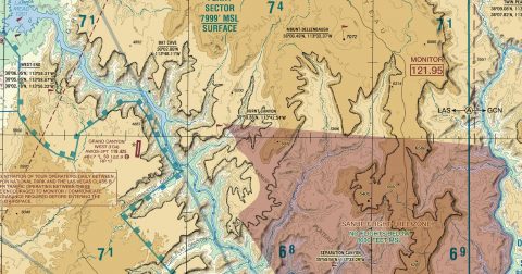
Go PROA single special-purpose sheet covering the Grand Canyon National Park Special Flight Rules Area, where flight is restricted to protect the canyon from noise. It shows the corridors, minimum altitudes and no-fly zones that apply, in far more detail than the surrounding sectional can carry.
It is the chart that makes a scenic flight through the canyon possible to fly correctly rather than approximately, which is exactly the sort of flight simulator pilots make.
Yes, all 1 of them, with no account required. FAA charts are United States Government works and are not subject to copyright protection in the US under 17 U.S.C. § 105. Guest downloads are speed-capped; PRO members download at full line speed.
Every 56 days. The current edition took effect on 10 October 2026 and is superseded on 10 October 2026. We fetch and publish each new edition on its effective date.
Every chart comes as both a georeferenced GeoTIFF — 300 dpi, with a world file and FGDC metadata, for loading into moving-map software — and a print-ready PDF with no georeferencing, for printing or reading on screen.
FAA public-domain products, mirrored unmodified. Fly Away Simulation is not affiliated with or endorsed by the FAA. Chart licensing and terms.