Page 2
Searches the whole library — filter by sim & category on the results page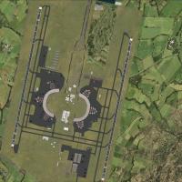
At the airport in Jakarta, Indonesia (WIII), Terminal 3 is included and airlines assigned to it use the new facilities, while assigned parking and updated taxiways accompany extra fuel trucks. Two …
 Indonesia
Three BGL files target SCEL in Santiago, Chile: SCEL_ADE_RS.BGL acts as the main airport file, SCEL_ADE_CVX.bgl removes trees and buildings for the new runway 17R/35L and parts of the cargo apron, …
 Chile
Chile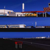
Gustavo Luna delivers an enhanced Aracaju SBAR layout that features precisely labeled taxiway signage, structures reflecting local architecture, and lighting tuned for evening operations. It center…
 Brazil
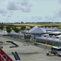
This project recreates Barbados' Grantley Adams International Airport (TBPB) with 3D terminal models in GMAX, photoreal ground polygons, and a 3D taxi lighting and approach lighting system for Runw…
 Barbados
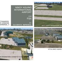
An accurate depiction of Ninoy Aquino International Airport (RPLL) relies on satellite imagery and aerial photos, while nearby rivers and roads are rendered with AI vehicular traffic and the lakes …
 Philippines
The airport at Muscat (OOMS) receives a coastline fix and a photoreal base, complemented by a new road network and Muscat-specific landclass, with all main buildings custom designed from available …
 Oman
Oman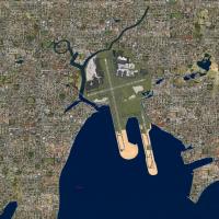
Two variants exist for Sydney's Kingsford Smith airport, named YSSY_ADE_RS.BGL and YSSY_ADE_CW_RS.BGL, produced with ADE Home Edition (Freeware) by Ray Smith. The CW_RS file activates the Xwind run…
 Australia
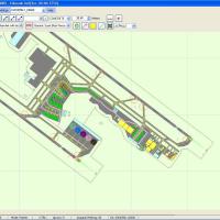
Located in Bogota, Colombia, Eldorado airport carries the code SKBO and serves Avianca as a main hub with many daily flights to Colombian cities, highlighting its importance in regional air travel.…
 Colombia
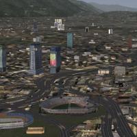
Caracas VFR project by David Maldonado adds skyscrapers over 100 meters and representative buildings to Caracas, while incorporating highways with vehicular traffic and avenues and streets; the SVF…
 Venezuela (Bolivarian Republic of)
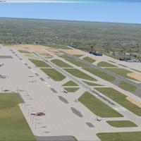
Matthew Brooks and Alpha India Group rework Hongqiao International Airport (ZSSS) with Airport Design Editor 1.47.07, adding runway 18R/36L, terminal 2 with integrated rail, and expanded aprons and…
 China
China
Located at LEAB, Spain, the project is v1.0 featuring AI traffic, photo-real imagery, buildings, and navigation charts, and supports two B-737s plus four light aircraft. The field serves the Air Fo…
 Spain
Spain
The image set arrives in eight parts, with Parts 1–2 dedicated to field imagery, Parts 3–7 to non-field areas, and Part 8 to town areas, spanning American and European regions. The author adjusts t…
 Global (World)
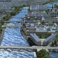
By Marc Guitteny, v1.2 for the Paris area spans about 140 km2 and includes La Defense along with western towns, and adds new autogen, buildings, and a photo-real mesh with bridges placed accurately…
 France
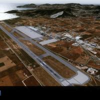
Sierra.Foxtrot-Design identifies LEIB_Ibiza_X as the SFD_LEIB_Ibiza_X directory, designed for integration within an Addon Scenery structure and containing the necessary components. Users place the …
Spain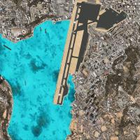
Navigational aids ILS and LOC are added for Kai Tak, Hong Kong, with Runway 13 featuring a 75-degree turn on final, and the update is credited to J. D. Starseed of Starseed Productions LLC, distrib…
 Hong Kong
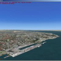
By Toni Agramont, this scenario adapts a prior Portuguese project for VFR flights and encompasses 30 airports and aerodromes across the country. Autogen density is Dense, water effects are None, an…
 Portugal
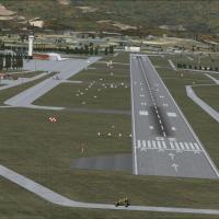
An ADE9X-based enhancement for Khatmandu Tribhuvan Airport (VNKT) in Nepal uses Google Maps satellite imagery and adds birds, while an ILS is included for landings despite VNKT lacking one in reali…
 Nepal
Nepal
An upgrade at WMKK adds A380 gates and the LCCT, while taxiways and taxi signs are updated and extra fuel trucks support ground operations. Three BGL files exist: WMKK_ADE_RS.BGL, WMKK_ADE_RS_CVX.B…
 Malaysia
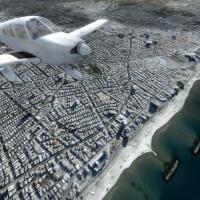
By FTXDes, the 22,072-square-kilometer add-on delivers 1m-per-pixel detail across Israel, Palestine, the Golan Heights, and the Gaza Strip, with major cities such as Tel Aviv and Jerusalem depicted…
 Israel
Oakland International Airport KOAK receives a complete rebuild that reworks terminal facilities, adds a FedEx Hub, and places new commercial structures near runway 11. It aligns runways and aprons …
 United States of America