Page 120
Searches the whole library — filter by sim & category on the results page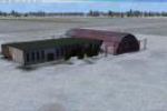
The Suwalki EPSU representation uses a 1m/pix photo imagery with seasonal and night variations, plus a 3D apron and custom buildings. It carries the ICAO code EPSU, places Suwalki, Poland, and prov…
 Poland
Kenichi Ochiai presents a version 2.2 depiction of Iseshima Nishiki Bay in Japan. The work credits the creator and marks the geographic scope, noting the explicit edition as a named variant for the…
 Japan
Japan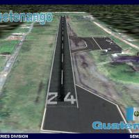
Huehuetenango hosts v1.0 of a Playa Grande facility in Guatemala, by Omar Eduardo Herrera Galindo, serving the Huehuetenango region. SEMARV design integrates Gmax objects, generic objects and landc…
 Guatemala
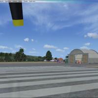
Two .bgl files add the runway reopening at Barking Sands PHBK and expand facilities at Port Allen PAK on Kauai, Hawaii. The package injects runway lights and adds aircraft and buildings, while pres…
 United States of America
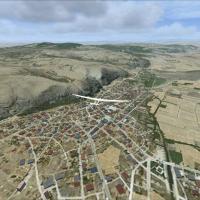
Sunay Kilic provides is-LTIN.bgl, a small fix that removes thermals over LTIN Inonu airfield and nearby Inonu city, reducing interference with autogen houses and smoothing glider landings. The modi…
 Turkey
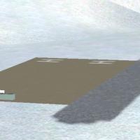
Located at Mount Rainier in Washington, the project centers on a fictional airport carved into the mountainside at elevations over 13,000 feet. By Andy Johnston, it foregrounds the distinctive moun…
United States of America
Located in the central North Island of New Zealand (NZCG), near Taupo, Centennial Park marks an airfield that serves the Taupo Gliding Club and sits beside the Taupo Horse Racing Track and Taupo Mo…
 New Zealand
NL2000 v4.03 EHMZ Zeeland Airport is a variant within the NL2000 v4 lineup and relies on the NL2000 v4.0.32 installer to merge into the modular Netherlands-wide framework. The NL2000 v4 framework c…
 Netherlands
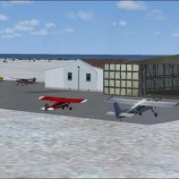
Located near Provincetown, Massachusetts, this add-on presents a revised terminal and aircraft hangar, three fuel trucks with a fuel station, taxiways of the correct length and width, static aircra…
United States of America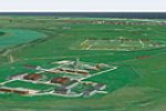
An add-on on Foulness Island, built after WWI by A&AEE and RAF, presents two variants for VFR Real terrain and default terrain. It includes three Leander-class frigates at sea, several custom model…
 United Kingdom
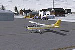
An improved KBVY upgrade adds aprons, roads and taxiways, replaces most default structures, and adds parking, static vehicles, aircraft and light poles, while relocating a radio tower to better ref…
United States of America
KERI, the airport in Pennsylvania, gains upgraded hangars including a new east-end unit and a replaced terminal, while three moving jetways interact with AI traffic. It also replaces the surroundin…
United States of AmericaJeki Airstrip (FLJK) lies in Zambia’s Lower Zambezi National Park and serves visitors, including game hunters, with commercial use by Proflight Zambia. A photoreal depiction presents the site, whil…
 Zambia
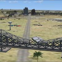
An add-on for Taji, Iraq by Steven Dean, adds military objects, buildings, and an emergency scene, and remains clearly fictional. It includes taji.bgl and taji2.bgl files to be placed in the addon …
 Iraq
Iraq
Alexandra Airport (NZLX) in Otago, New Zealand, gains a functionality-enhancing improvement and a revised airport layout file by Kade Bellaney, using ADE 1.45. A blg file is included in the archive…
New Zealand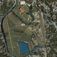
Located in southern Germany, Uwe Schweitzer presents Lichtenfels Airport (EDQL) as a photo depiction, a site about 15 nm WNW of Kulmbach serving a small aero club airfield in Franconia. It supports…
 Germany
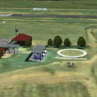
The work centers on Ficksburg Airport in the Free State, South Africa, at the foot of Mpharane Mountain on the Caledon River, featuring completely custom-designed objects and effects and a base tha…
 South Africa
Two BGL files, KCON_AFX_JC.bgl and KCON_JC.bgl, govern Concord Municipal Airport in New Hampshire, upgrading taxiways, aprons, and roads, replacing default buildings with new structures, and adding…
United States of America
A refined Lehigh Valley International (KABE) adds cargo and GA parking, a helipad, and a relocated control tower while adjusting aprons and taxiways and replacing several buildings with more accura…
United States of America
Secunda Airfield (FASC) in South Africa presents a detailed depiction, with the Sasol plant to the south. Its geographic reference centers the airfield against an industrial landmark and clarifies …
South Africa