Page 130
Searches the whole library — filter by sim & category on the results page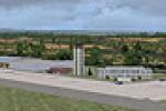
Jacques Botha codes the FABE depiction, recreating the primary runway with native tools and rendering nearby terrain and structures to resemble Bhisho in the Eastern Cape. The project is freeware, …
 South Africa
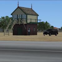
An add-on by Pedro Vendeira adds hangars, a fire station, a control tower, and static planes to Espinho, Portugal, with these elements forming the layout for the airfield environment. The kit uses …
 Portugal
Located in Dumfries and Galloway, Scotland, it sits near the Dumfries and District Gliding Club and uses files from all four volumes of Neil's Microlights, plus UKVFR and Acceleration, by Neil Birc…
 United Kingdom
MMZP elevation fix removes a hole at Zapopan Airport in Jalisco, Mexico, by Alex Dzeda. The note centers on the Zapopan site, while Alex Dzeda serves as the author for this adjustment, which target…
 Mexico
John B. Jensen creates Grenaa Flyveplads EKGR ver. 1.0, a Danish airfield at EKGR, with an animated windsock credited to jdberg, JonPatch, and arno. The build relies on Gmax, SbuilderX, Airport Des…
 Denmark
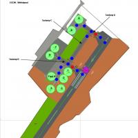
Three files accompany Welshpool Airport, including EGCW.bgl (airport AFD), EGCWtrees.bgl (optional trees), and EGCWbuildingsbgl (replaces buildings after exclusion) to better reflect topography wit…
United KingdomThe update adds the missing VOR/DME CLE (Calella) in Spain to the base navigation aids, enabling approaches to Barcelona LEBL. A BGL file named VOR cle.bgl creates this facility, and it is necessar…
 Spain
Spain
Norway hosts a freeware by Marius Risan, identified by the file name Jarlsberg. A glider remains visible in the air above Jarlsberg Airport, grounding the scene in Norway and noting the work's Norw…
 Norway
Chimoio Airport in west Mozambique gains a detailed layout including the main building, fire truck station, taxiways, runway approach lights, and a VOR, provided by Hassan Ezzeddine for a flight-si…
 Mozambique
Peace Airport (ZUSH) near Shigatse in Tibet serves mixed civilian and military operations, with elevation 9675 ft (2949 m) above mean sea level and coordinates N29 21 06, E89 21 41. The runway runs…
 China
China
A refined depiction of the regional airport near Seneca Falls, identified by 0G7 in New York, adds taxiways and aprons, replaces some buildings, and introduces static planes, vehicles, and other ob…
 United States of America
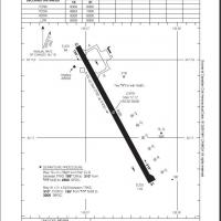
Prince Rupert Airport CYPR in British Columbia gains a refined layout with a revised runway alignment, newly positioned ramps, enhanced parking zones, and added static library objects that rely on …
 Canada
Namibia's Ruacana airport, registered FYRC, sits near the border with Angola and serves visitors heading to Ruacana Falls. The project uses default libraries and includes a folder named FYRC_Ruacan…
 Namibia
Version 2.0 presents the Thanlwin Bridge at Mawlamyine, designated VYMM, spanning 11,575 feet with a 28-foot-wide two-lane motorway two miles long, a 14-foot-wide railroad four miles, and two six-f…
 Myanmar
FLMF in Zambia receives runway, taxiway, and elevation refinements based on real AIP documents, and gains a photoreal ground surface that enhances the field’s layout. By Jens Weissflog, it builds o…
 Zambia
In Idaho's Henry’s Lake region (U53) near Yellowstone, the area spans roughly 25 square miles and uses 486+ library items from the default library plus external sources. Runway 6 presents a blackto…
United States of America
Europa FAV presents a modeled island with a main airfield FMXX equipped with ILS, a GA field FMXY offering lodging for pilots, and a water field FMXZ for seaplanes. Dominique M. L. Donzelot notes i…
 France
Author Gera Godoy Canova documents a western Africa focus, providing .BGL assets and .BMP textures alongside .PL, .FLT, .FSSAVE, and .WX files. The compilation organizes resources into two subdirec…
 Global (World)
Barrow/Walney Island Airport sits on Walney Island and carries IATA BWF and ICAO EGNL, owned by BAE Systems which operate private flights across the United Kingdom; a triangular runway layout marks…
United Kingdom
Elmira, New York’s Harris Hill Gliderport (registration 4NY8) receives a revised layout that adds a second parallel runway and multiple structures, static gliders, planes, and vehicles. Files named…
United States of America