FSX Scenery

Page 18

Sort
Reset
Preview screenshot

Kadena AB And Okinawa Islands

By Ian W, this freeware depiction covers Kadena AB (RODN) and five Okinawa airstrips, naming Yoron Island (RORY), Iejima (RORE), Aguni (RORA), Kumejima (ROKJ), and Kerama (ROKR). A flight plan runs from Yoron to Kadena and is provided in two formats, with the Kadena_&_Okinawa_Islands folder included.

Country
Japan
File Size
1.27 MB
Total Downloads
2.5K
Star Rating
4/5
Screenshots
4
Preview screenshot

Scenery--Berlin Landmarks

Edgar Knobloch fixes the location and size of several Berlin buildings in Germany, with the changes captured in berlfsfx.gif, a GIF file used to illustrate the adjustment, which targets the urban geometry for better alignment with the city's layout.

Country
Germany
File Size
4.43 KB
Total Downloads
2.4K
Preview screenshot

Caribbean Seaplane Tours Florida

An aircraft environment add-on covers a network of Florida and Caribbean aviation sites, spanning Key West, Miami, Havana, Marathon and beyond. By Chris Carel, it lists 19 navigation locations with VOR references and fuel availability, and includes several aircraft designs across docks such as Key West Docks and Mooney Harbor.

Country
Global (World)
File Size
68.47 MB
Total Downloads
2.4K
Star Rating
5/5
Screenshots
40
Preview screenshot

Gold Coast Airport

An accurate depiction of the Gold Coast region airport YBCG in Australia, this rendition notes a 2500-meter runway upgrade and a widened apron. Coastline changes extend beaches to Byron Bay and a canal network behind Surfers Paradise, while all models use Gmax or FSDS3.0 by John Ross.

Country
Australia
File Size
12.26 MB
Total Downloads
2.2K
Star Rating
2/5
Preview screenshot

Liverpool

By Gareth Davies, this Liverpool city-center depiction aligns with the Ultimate Terrain Europe addon and covers most major buildings, including the Bidston Hill Telescope on Wirral; it has not been tested with the default or VFR terrain.

Country
United Kingdom
File Size
9.1 MB
Total Downloads
2.2K
Star Rating
5/5
Screenshots
1
Preview screenshot

30cm Generic Project Textures Rocks Mountains

Global rock surfaces shift from 1 meter to 30 centimeter resolution, delivering finer detail across mountain regions worldwide and enhancing topographic cues for landscape comprehension. Only summer visuals are available, and the work bears the credit of Aime Leclercq.

Country
Global (World)
File Size
888.26 MB
Total Downloads
2.2K
Star Rating
5/5
Screenshots
8
Preview screenshot

Albuquerque International (KABQ)

At Albuquerque's KABQ, a higher-resolution terminal accompanies new tarmac lighting and jetways, while two large hangars at the end of runway 8 and the Wyndham Hotel remain visible. Files include 000_excl.bgl, KABQ.bgl, KABQ_Scn.bgl, and KABQ_LC.bgl; an LTS file is required for the lights, original by Kevin Troutman, revision by Grant G.

Country
United States of America
File Size
1.26 MB
Total Downloads
2.2K
Star Rating
5/5
Screenshots
1
Preview screenshot

Cardiff International Airport

Located at EGFF in South Wales, this project features 5m mesh terrain and numerous custom Gmax buildings modeled from photographs, with St. Athan RAF Base and TV masts at St. Hilary and Wenvoe included; Porthkerry Viaduct is provided for VFR photographic use only.

Country
United Kingdom
File Size
2.73 MB
Total Downloads
2.2K
Star Rating
3/5
Screenshots
2
Preview screenshot

Bristol International Airport (EGGD)

The airfield near Bristol in the UK, designated EGGD, is modeled with Gmax for buildings, ADE9X for taxiways and gates, and samm for static aircraft. Static aircraft and 2D passengers and ground staff accompany a terminal, plus photoreal runway surfaces; the BristolX folder is included, by Harry Patten.

Country
United Kingdom
File Size
29.13 MB
Total Downloads
2.2K
Preview screenshot

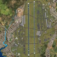
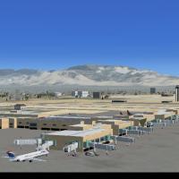
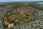
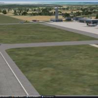
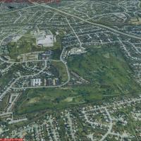
Bradley International Airport

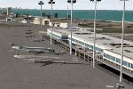
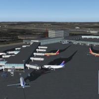
Bradley airport (KBDL) in Windsor Locks, CT gains a remapped gate layout with an extended A-Concourse and added jetways, plus a Marriott hotel, parking structure, and an old control tower nearby, while three BGL files: KBDL_NEW_J.bgl, IS_KBDL.bgl, and JonPatch_objects_2, provide the updated configuration, with JonPatch_objects_2 supplying light-pole library objects.

Country
United States of America
File Size
698.97 KB
Total Downloads
2.2K
Screenshots
3
Preview screenshot

Locher/Sarentino Airfield

Locher airfield sits on private grass near Sarentino in Trentino, presenting three start points: Runway 17, Parking 1, and Parking 2, with no defined runway or taxiways and a steep slope affecting takeoff. It carries the LILX ICAO code and features photoreal ground, a large custom mesh, and south-side landmarks.

Country
Italy
File Size
409.79 MB
Total Downloads
2.2K
Star Rating
5/5
Screenshots
60+
Has Video
1
No image available.

Mount Everest

Two consolidated parts deliver an Everest massif revised by Frank Dainese, with the area encompassing Nepal’s high-altitude surroundings. The included .bgl files carry imagery for reliable loading, and an optional Himalayas LOD10 mesh by Holger Sandmann and Jonathan de Ferranti (fs_him_01.zip) sharpens terrain near Lukla airport.

Country
Nepal
File Size
136.43 MB
Total Downloads
2.2K
Preview screenshot

KMHV, Mojave Airport, V2.0

Mojave Airport is a former World War II desert airfield now a center for civilian aviation R&D and a major aircraft storage and scrap yard, hosting the National Test Pilot School and Burt Rutan's Scaled Composites. Around 90 airplanes reside here, including several 747s.

Country
United States of America
File Size
378.29 KB
Total Downloads
2.2K
Screenshots
3
Preview screenshot

Ants Aussie Airports Vol. 4

Three airfields in the Darwin region—Darwin International (YPDN), Royal Darwin Hospital helipad (YXDH), and Robertson Barracks (YRBK)—receive custom-built models and photoreal backdrops designed to blend with ORBX FTX imagery. The Vol 4 set provides aaa4_DarwinHospital_Photo.bgl, aaa4_DarwinHospital_Scenery.bgl, aaa4_DarwinHospital_Windsock.bgl, and AFX_aaa4_YXDH Darwin Hospital.bgl.

Country
Australia
File Size
47.5 MB
Total Downloads
2.2K
Preview screenshot

RPMD - Francisco Bangoy International

By Matthew Brooks and Alpha India Group, RPMD v2 updates aprons and taxiways to align with imagery dated February 2010 and rewrites approaches per Jeppesen plates. It adds GA parking, a fire station, cargo terminal, and a rooftop tower view, and includes AIG_RPMD_ADEX_MB_Default.BGL, AIG_RPMD_ADEX_MB_CVX_Default.BGL, lightobj.bgl, almwht.dds, and lights1.dds.

Country
Philippines
File Size
1.69 MB
Total Downloads
2.1K
Screenshots
1
Preview screenshot

Lugano Airport

Lugano-Agno's airport LSZA gains depth as Project JBG and Joe Garcia rework taxiways and the tarmac to match real configuration, with most structures generated from Gmax, and the lugano_jbg_v1 folder containing added car parks, people, vehicles, and static aircraft from local airlines.

Country
Switzerland
File Size
2.22 MB
Total Downloads
2.1K
Star Rating
1/5
Screenshots
4
Preview screenshot

Air America In Laos - Vietnam War Project

The Laos-focused Vietnam War era project covers 29 airfields near Vientiane, Pakse and Long Tieng, along with 26 Lima Sites rendered onto photoreal ground layouts. By Xavier Carré, it requires VNW_V09.ZIP, VNW_AP1.ZIP, and SRTM West Asia meshes in five parts (SRT2WAS1–SRT2WAS5.ZIP).

Country
Lao People's Democratic Republic
File Size
122.49 MB
Total Downloads
2.1K
Star Rating
1/5
Screenshots
11
Preview screenshot

Lexington Photoreal

Jim Jones crafts ten sections of one-meter-per-pixel photoreal terrain data for Lexington, KY, totaling about 600 MB and spanning roughly 245 square miles, LexXP1Ma through LexXP1Mj. Daylight use applies; you do not need to add extra mesh.

Country
United States of America
File Size
648 MB
Total Downloads
2.1K
Star Rating
4/5
Screenshots
17
Preview screenshot

Montego Bay Airport

Montego Bay project covers Sangster International Airport (MKJS) and its surrounding area, applying landclass and runway-taxiway-parking changes guided by Google Earth imagery and diagrams by Anthony Scott. A new terminal building is added and the floating generic structures are replaced, by Art Poole.

Country
Jamaica
File Size
642.53 KB
Total Downloads
2K
Screenshots
2
Preview screenshot

Los Llanos Albacete

Located at LEAB, Spain, the project is v1.0 featuring AI traffic, photo-real imagery, buildings, and navigation charts, and supports two B-737s plus four light aircraft. The field serves the Air Force, civil, and Private Wings, while La Maestranza Aerea handles modifications and overhaul of Mirage F-1s and other Air Force aircraft.

Country
Spain
File Size
93.66 MB
Total Downloads
2K
Star Rating
5/5
Screenshots
1