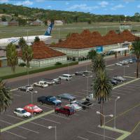
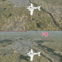
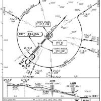
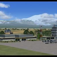
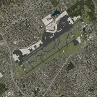
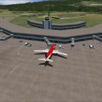
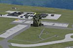
FSX Scenery

Page 20

Sort
Reset
Preview screenshot

Wyoming Photoreal

Wyoming-wide photoreal imagery provides 1 meter per pixel resolution, enabling clear delineation of terrain and urban layouts across the state. Jackson Hole airfield appears in the collection, offering a tangible reference for regional pilots and enabling smoother navigation.

Country
United States of America
File Size
25.1 GB
Total Downloads
1.5K
Star Rating
5/5
Screenshots
32
Preview screenshot

Campo Grande International Airport

Cristobal Laje creates the SBCG scenario for Campo Grande International Airport in Mato Grosso do Sul, Brazil. It uses default objects drawn from libraries, with a radar fixed to the SBCG folder, and it does not test with other versions.

Country
Brazil
File Size
5.72 MB
Total Downloads
1.5K
Star Rating
2/5
Screenshots
30
Preview screenshot

Catalina Island (KAVX)

Quality depiction centers on Catalina Island, identified by the KAVX code, delivering photorealistic rendering with a highly detailed airport and satellite imagery. Autogen stays off beyond the airport area, and daylight imagery remains the only visual style, with this contribution by Cassidy Byars.

Country
United States of America
File Size
17.12 MB
Total Downloads
1.5K
Star Rating
5/5
Screenshots
2
Preview screenshot

Chernobyl

An expansive layout centers on the Chernobyl NPP as it appears from 1997 to 2005, with a custom built reactor building and extensive landclass textures for the surrounding area. NPP6 uses default objects near the site, and the project includes river features such as Pripyat, Uzh, and Dneiper.

Country
Ukraine
File Size
4.43 MB
Total Downloads
1.5K
Star Rating
5/5
Screenshots
20
Preview screenshot

RAF Fairford 2009

Underpinning RAF Fairford 2009 (EGVA) in the UK are SBuilderX, ADE and Whisplacer, referencing airfield coordinates from Google Earth and Google Maps. A CVX directory includes EGVA_ADE_DEF_CVX and EGVA_ADE_VFR_CVX, while parking supports about 55 aircraft and one CVX option places borders 1–2 km from the airfield.

Country
United Kingdom
File Size
5.49 MB
Total Downloads
1.5K
Star Rating
1/5
Preview screenshot

Des Moines International Airport (KDSM)

An FSDS-built terminal area updates the facility at the KDSM region, adding a dedicated Iowa Air National Guard 132nd Fighter Wing area and ensuring gates are accurately portrayed. Gates are numbered and coded using Airport Design Editor 1.50.4402, and an option allows both runways to serve AI traffic.

Country
United States of America
File Size
2.35 MB
Total Downloads
1.5K
Star Rating
3/5
Screenshots
1
Preview screenshot

Scenery--France 38 m Terrain

France-wide terrain mesh reaches version three, providing coverage at 38-meter resolution across France. It replaces earlier releases 1 and 2 and fixes issues, with creation by Raimondo Taburet in collaboration with Emile De Mesmaeker and released into the public domain.

Country
France
File Size
49.68 MB
Total Downloads
1.5K
Screenshots
1
Preview screenshot

Jundiai

Version 2.0 covers Jundiai Airfield (SDJD) near Sao Paulo, Brazil, with altitude corrections, improved runway markings, and new parking positions and lights, Ren Scen earns credit. Brazilian locale details anchor the revision, with SDJD highlighted as the focal point and improvements extending to lighting and parking layouts.

Country
Brazil
File Size
114.17 KB
Total Downloads
1.5K
Star Rating
1/5
Screenshots
2
Preview screenshot

Mogadishu X

By Frits Beyer and Jacques Botha, Mogadishu X re-creates Mogadishu International Airport with a seasonally shifting base, plus a redesigned coastline, roads, and landclass. A custom AFX_HCMM_ALT.bgl anchors the HCMM area, two downed Blackhawks mark known crash sites near the harbor and Olympic Hotel, and military objects by Michael Carr enhance the layout.

Country
Somalia
File Size
40.39 MB
Total Downloads
1.4K
Screenshots
1
Preview screenshot

WWII Scenery Seaplane Aerodromes

The project encompasses thirteen Pacific Theater locations anchored by USS Bering Strait AVP-34 at Okinawa, with seven AI seaplane tenders at Kerama Retto and a water runway lit at night. Explorers can operate Martin PBM flying boats or PBY Catalina aircraft to add historical ambience.

Country
Global (World)
File Size
14.43 MB
Total Downloads
1.4K
Screenshots
9
Preview screenshot

Fort Myers FL Airports

A thorough overhaul of KRSW and KFMY reshapes the Fort Myers area, with landclass changes and a new terminal located on the opposite side of KRSW. KFMY gains redesigned taxiways, aprons, and hangars, and the package includes a library of new airport buildings and the Airport_Buildings_AP.bgl object library, authored by Art Poole.

Country
United States of America
File Size
1.41 MB
Total Downloads
1.3K
Star Rating
5/5
Screenshots
42
Preview screenshot

Chicago Midway Airport

Midway airport, designated KMDW, undergoes a remodel that emphasizes a highly detailed perimeter with runway and taxiway shoulders, overrun areas, and service roads. The overhaul includes three named KMDW files and requires no additional addons.

Country
United States of America
File Size
8.81 MB
Total Downloads
1.3K
Star Rating
5/5
Screenshots
21
Preview screenshot

Skara Scenery Aruba X

Queen Beatrix International Airport in Oranjestad, Aruba, serves as a hub with flights to the United States, the Caribbean, northern coastal countries of South America, Canada, and Europe, notably the Netherlands. Air Aruba formerly used it as a hub, and Aruba separated from the Netherlands Antilles in 1986, with Air ALM hubs; by Skara.

Country
Aruba
File Size
48.1 MB
Total Downloads
1.3K
Screenshots
11
Preview screenshot

Freedom Tower

Freedom Tower by Cliff Crane presents day, night and specular lighting through 1024x1024 DTX assets with mipmaps. The approach emphasizes surface detail and lighting fidelity, with mipmapped 1024x1024 assets that support smooth transitions across viewing angles.

Country
United States of America
File Size
452.22 KB
Total Downloads
1.3K
Screenshots
2
Preview screenshot

ISS Over KPAM

Bruce Fitzgerald presents an International Space Station pass over KPAM, positioned at 900,000 ft above Tyndall AFB, Florida, with autonomous reach to 600,000 ft and a brief de-orbit toward KSC. The ISS_KPAM folder and ISSX.BGL, along with BMP image files, support custom placement through the Object placement tool.

Country
United States of America
File Size
498.48 KB
Total Downloads
1.3K
Screenshots
1
Preview screenshot

Milford Sound Airport

Two available screenshots document Milford Sound airstrip (NZMF) in New Zealand, credited to Lets Fly Association and Shigeru Tomino. They originate from two image references that present the site and its geographic context, offering a concise visual record of the location.

Country
New Zealand
File Size
6.81 MB
Total Downloads
1.3K
Screenshots
3
Preview screenshot

Konya Airport (LTAN)

Sunay Kilic designs the LTAN Konya airfield add-on, crafted primarily with FSDS 3.5.1 and including an afd file. It features a photoreal 8km by 8km terrain area at 1m resolution with day and night coverage.

Country
Turkey
File Size
73.18 MB
Total Downloads
1.3K
Screenshots
8
Preview screenshot

Andorra Photoreal Scenery V2

Version two expansion adds about 650 square kilometers of photoreal coverage around LESU and LECD in Spain, and corrects both airfields. Authored by Andy Aundrias and requires ANDORRA-FSX.ZIP to operate on compatible hardware setups properly.

Country
Andorra
File Size
153.25 MB
Total Downloads
1.3K
Screenshots
1
Preview screenshot

openVFR The Netherlands Terrain

OpenVFR leads a Netherlands terrain enhancement that uses OpenStreetMap data to render land use, roads, rail lines, waterways, and points of interest across the Dutch landscape. The approach relies on vector-based mapping, minimizing conflicts with other visual elements, and the project is led by Markus Freyt, with free download available.

Country
Netherlands
File Size
21.46 MB
Total Downloads
1.3K
Star Rating
5/5
Preview screenshot

Update For Swiss Airports

Forty-one Swiss airfields and bases gain enhancements, including expanded parking, taxiways, night lighting, control towers, and tower frequencies. BR2_ICAO.bgl files are included and usable with or without MyTrafficX, while Airports.txt, Aircraft.txt, and Flightplans.txt accompany Traffic Tools generated flightplans.

Country
Switzerland
File Size
78.55 MB
Total Downloads
1.3K
Screenshots
1