Terminal Procedures

KVBG — Vandenberg Space Force Base

LOMPOC, CA · 12 FAA charts · cycle 6 Aug 2026

FAA VBGElevation 368 ft1 runwayLongest 15,000 ftToweredFuel A++Volume SW-3Not for navigation
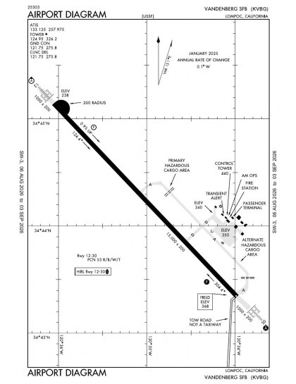
KVBG airport diagram — runways, taxiways and ramp layout
KVBG airport diagram The official FAA airport diagram — runways, taxiways, ramp layout and hold-short positions. Download PDF

8 published instrument approaches: 4 ILS approaches, serving 2 runway ends.

All 12 KVBG charts in one download Every approach, departure, arrival and minimums page for this airport, sorted into folders, as a single ZIP. Taken one at a time on the free tier, 12 charts is roughly 1 min of downloading — they queue one behind another.
PRO members only

Instrument approach procedures

ChartAmendment
HI-ILS OR LOC/DME RWY 12 chart previewHI-ILS OR LOC/DME RWY 12PDF
HI-ILS OR LOC/DME RWY 30 chart previewHI-ILS OR LOC/DME RWY 30PDF
HI-TACAN RWY 12 chart previewHI-TACAN RWY 12PDF
HI-TACAN RWY 30 chart previewHI-TACAN RWY 30PDF
ILS OR LOC/DME RWY 12 chart previewILS OR LOC/DME RWY 12PDF
ILS OR LOC/DME RWY 30 chart previewILS OR LOC/DME RWY 30PDF
TACAN RWY 12 chart previewTACAN RWY 12PDF
TACAN RWY 30 chart previewTACAN RWY 30PDF

Departure procedures

ChartAmendment
GAVIOTA THREE chart previewGAVIOTA THREEPDF
VANDENBERG THREE chart previewVANDENBERG THREEPDF

Takeoff and alternate minimums

ChartAmendment
TAKEOFF MINIMUMS chart previewTAKEOFF MINIMUMSPDF

Minimums pages cover a whole volume, so the same document is shared by every airport in it.

KVBG airport information

Control tower
Yes
Attendance
All all 1600-0100z++
ARTCC
Los Angeles Center
Flight service
Hawthorne
NOTAM facility
HHR (NOTAM-D available)
Magnetic variation
12E
Beacon
White-green (lighted land airport), sunset to sunrise
Wind indicator
Yes
Fuel
A++
Airframe service
Major
Powerplant service
Major
Bottled oxygen
None
Customs
Landing rights airport
Ownership
Privately owned
Sectional
Los Angeles

From the FAA NASR 28-day subscription, cycle 6 Aug 2026.

KVBG radio frequencies

ServiceFrequencyCall sign
CTAF124.95
Ground121.75Vandenberg
ATIS133.125Vandenberg
Approach124.15Vandenberg
Emergency121.5Vandenberg

Civil VHF frequencies from the FAA NASR 28-day subscription. Discrete sector and military frequencies are not listed.

Runways

15,000 × 200 ft1230N3,000 ft
Runway layout at KVBG, drawn to scale from FAA published runway-end coordinates and true alignments. Runways served by an ILS are highlighted.
RunwayLengthWidth SurfaceLighting
12/3015,000 ft200 ftConcrete GoodHigh intensity
  12 137°TILS · PAPI (4-box) 3° · ALSF-2 approach lighting
  30 317°TILS · PAPI (4-box) 3° · ALSF-2 approach lighting

Runway and approach-aid data from the FAA NASR 28-day subscription.

Where KVBG is

Latitude, longitude34.7373370, -120.5843130
Elevation368 ft
From Lompoc7 nm NW

Paste the coordinates into a simulator’s world map to drop straight onto the field.

FAA remarks for KVBG

  • AUTHORIZED FOR MILITARY USE ONLY. SAC/SPACE AND MISSILE TEST CENTER, AFSC.
  • BCN OTS.
  • WHEN ATCT CLSD ACTVT ALS RWY 30; PAPI RWY 30; HIRL RWY 12/30 - CTAF.
  • FSS-HAWTHORNE HHR-NOTAM KVBG
  • TFC PAT: OVERHEAD 2400, RECTANGULAR 1400 FT, LGT ACFT/COPTER 900 FT.
  • CLSD SAT, SUN AND HOL.
  • RWY 12 APCH LGT SYS IS NSTD ALSF2 CONFIGN.
  • RWY 30 APCH LGT SYS IS NSTD ALSF2 CONFIGN. THLD LGTS ARE 16 FT FROM THE USBL PAVEMENT SFC.
  • RWY 12 ILS AND PAPI GS NOT COINCIDENTAL.
  • RWY-LGTS: RWY 12 - SF.
  • RWY-LGTS: RWY 30 - SF.
  • JASU - 4(A/M32A-86) 2(AM32-95).
  • FLUID - SP PRESAIR LPOX LOX LHNIT.
  • OIL - O-148-156.
  • RSTD - ACTIVATION OF AN/APS 145 RADAR OR SIMILAR RADAR SYSTEMS IS PROH WHILE IN R2516, R2517, R2534A AND R2534B. CTC TWR ON GND PRIOR TO ENG START, ENG START OR AFLD OPR NOT AUTH TIL CTC WITH TWR IS MADE. NO INT DEP BTN OFFL SS-SR.
  • CAUTION - UNCTL CIV ARPT TFC 7 NM SE. WHEN ARPT IS VMC ACFT WILL NOT EXCEED 1900' TIL CROS DEP END OF RWY TO AVOID OVERHEAD TFC PAT. HVY AND LARGE ACFT ARE REQ TO USE MIN TAXI PWR AND SHUT DOWN OR IDLE OUTBOARD ENG TO AVOID BLOWING FOREIGN OBJECT ONTO PAVEMENT.
  • CAUTION - PRK RAMP IS NOT MRK FOR C-17 ACFT.
  • REMARKS - FOR BASH INFO, SEE FLIP AP/1 SUPPLEMENTARY ARPT RMK.
  • TRAN ALERT: LTD FLEET SVC AVBL, CTC AM OPS.
  • MISC: ALL ACFT REQ FULL STOP AT VBG OR SUPPORTING VBG VIP MOVEMENT, CTC PTD (OT COMD POST) 30 MIN PRIOR TO LDG. ALTN AFLD RQR. AM OPS DSN 276-6941/42, C805-606-6941/42 FAX EXTN 6664. RWY 12-30 GROOVED.
  • MISC: EARLY/LATE ACFT ARR/DEP BEFORE/AFTER PUBL OR SKED AFLD OPERATING HRS SHALL EXP HOLDING WITH APCH CTL OR ARTCC TIL AFLD IS OPEN OR RON IF DEP. ACFT SHALL CTC COMD POST AT DSN 276-9961 PRIOR TO DEP WITH UPDATED ARR TIME. ENSURE PILOTS CK NOTAMS PRIOR TO DEP AS NOTAM WILL REFLECT AFLD HRS BASED ON APPROVED AFTER HRS REQ. CTC COMD POST 30 MIN OUT OR EARLIER.
  • TRAN ALERT: POTABLE WATER SVC UNAVBL.
  • LTD TOW CPBLTY; CTC AIRFIELD MGMT FOR SPECIFICS.
  • CAUTION: MKGS ON PRKG APRON FADED AND NON-RETROREFLECTIVE.
  • RSTD: ALPHA ROW ENG RUN-UP AREA UNAVBL.
  • CSTMS/AG/IMG: CUSTOMS UNAVBL.
  • CAUTION: ALTN HAZ CARGO PAD DOES NOT HAVE TIE DOWNS.
  • MISC: ANY CHANGE TO ARR/DEP TIME MUST BE COORD THRU COMD POST, RE-APVL IS RQR IF NEW ETA/ETD IS OUTSIDE OF AFLD HRS OF OPR.
  • CAUTION: OBST LGT ON WATER TWR LCTD 1.3 SM SW OF RWY 30 THLD O/S.
  • CAUTION: ACFT TIE-DOWNS UNAVBL.
  • MISC: COMSEC MTRL MUST BE STORED AT SLD 30 COMD POST DSN 276-9961, C805-606-9961.
  • CAUTION - USE EXTREME CTN FOR EXTENSIVE UAS OPS IN VCNTY.
  • RSTD: PPR AT LEAST 24 HR IN ADVN, BUT NO EARLIER THAN 5 BUS DAYS IN ADVN. SEND EMAIL TO 30OSS.OSAA@US.AF.MIL FOR PPR REQ FORM. AM OPS DSN 276-6941 OR C805-606-6941/6942 FAX EXTN 6664. ACFT OPS OUTSIDE OF PUBL AFLD OPRG HRS MUST BE APV AT LEAST 48 HRS IN ADV THRU AFLD MGMT. GRD SUPPORT SVC UNAVBL FOR ARR/DEP OPS OUTSIDE OF PUBL OR SKED AFLD OPRG HRS.
  • MISC: AD WIND DRCTN INDCR OTS.
  • CAUTION: INADQT WIND INDICATORS (WINDCONES) FOR RWY 12/30.

Published verbatim from the FAA NASR subscription. Abbreviations are the FAA's own.

Instrument coverage

Vandenberg’s procedure set is strongly weighted towards arrivals, with eight approaches against two departures. Every published approach is either ILS or localiser, divided evenly between the two types. Both ends of Runway 12/30 are served, so instrument coverage is not confined to one landing direction. The sole runway extends for 15,000 ft, although its single 12/30 alignment provides no second runway axis.

Regional chart context

Santa Barbara has the broadest nearby chart set, while San Luis Obispo and Santa Maria have coverage close to Vandenberg’s. Santa Ynez and Lompoc have markedly thinner procedure collections. The Los Angeles Sectional adds the wider visual context around Lompoc that the airport diagram and procedure-specific charts do not provide.

Airports near KVBG

IDAirportCity DistanceCharts
KLPCLompocLOMPOC, CA7 nm SE4
KSMXSanta Maria Pub/Capt G Allan Hancock FldSANTA MARIA, CA12 nm NE10
KIZASanta Ynez/Kunkle FldSANTA YNEZ, CA26 nm E5
KSBPSan Luis Obispo County RgnlSAN LUIS OBISPO, CA30 nm N11
KSBASanta Barbara MuniSANTA BARBARA, CA41 nm SE15
KPRBPaso Robles MuniPASO ROBLES, CA56 nm N10

VFR charts covering KVBG

Common questions about KVBG

What charts are available for KVBG?

12 current FAA charts for Vandenberg Space Force Base, including 8 instrument approachs, 2 departure procedures, 1 airport diagram. All are free to download as PDFs from this page, from the 6 August 2026 cycle.

What are the radio frequencies for KVBG?

Ground 121.75; ATIS 133.125; CTAF 124.95. Full civil VHF list, with sector notes, is in the frequencies table on this page — from the FAA NASR subscription.

How long is the runway at KVBG?

Vandenberg Space Force Base has 1 runway. The longest is 12/30 at 15,000 ft by 200 ft, concrete. Full runway dimensions, lighting and approach aids are listed on this page.

Does KVBG have an ILS approach?

Yes — 4 ILS procedures are published. In total KVBG has 8 published instrument approaches.

Where can I download the KVBG airport diagram?

The official FAA airport diagram for Vandenberg Space Force Base is free to download at the top of this page. It shows runways, taxiways, ramp layout and hold-short positions, and is reissued every 28 days.

Is KVBG a towered airport?

Yes. Vandenberg Space Force Base has an operating control tower, within Los Angeles Center's airspace. Tower, ground and clearance frequencies are listed on this page.

Are these KVBG charts current?

They are from the FAA cycle effective 6 August 2026, which is superseded on 3 September 2026. We publish each new cycle on its effective date. They are for flight simulation and reference only — not for real-world navigation.

Wider chart sets

Bulk archives are a PRO benefit. Individual charts are free for everyone, always.

Flying into KVBG? PRO members take all 12 charts as one ZIP instead of 12 separate downloads, at full line speed with no cap — plus every chart family archive and all 24,000+ add-ons in the library.

Go PRO

Not for navigation. For flight simulation and reference use only. Procedures are superseded on a 28-day cycle — obtain current official charts from the FAA for real-world flight.

FAA public-domain products, mirrored unmodified. Fly Away Simulation is not affiliated with or endorsed by the FAA. Chart licensing and terms.